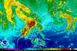
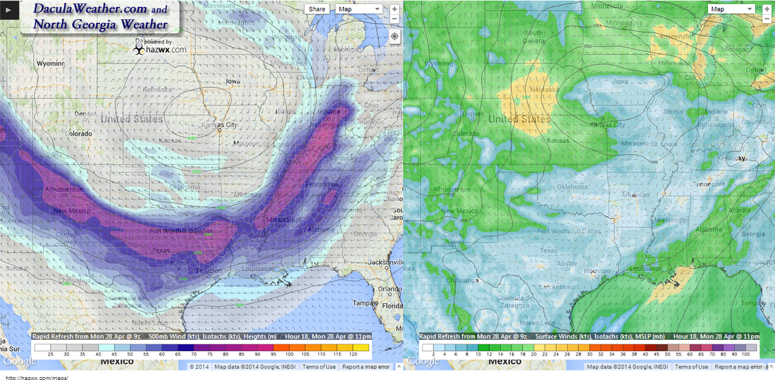
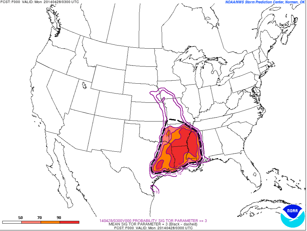
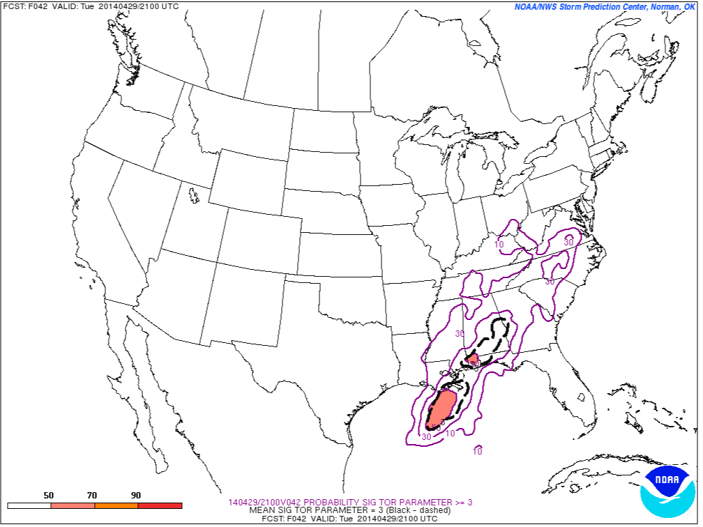
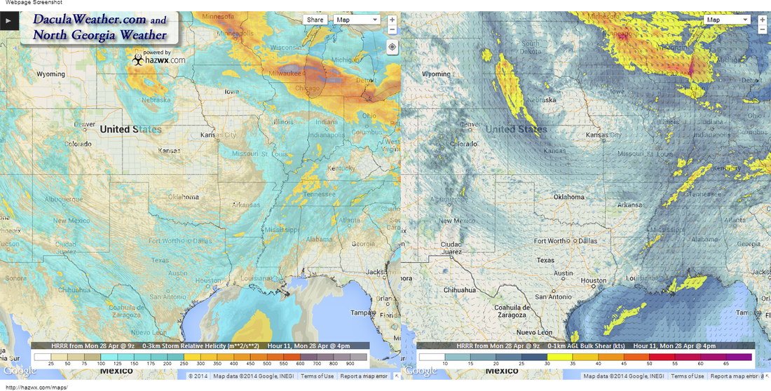
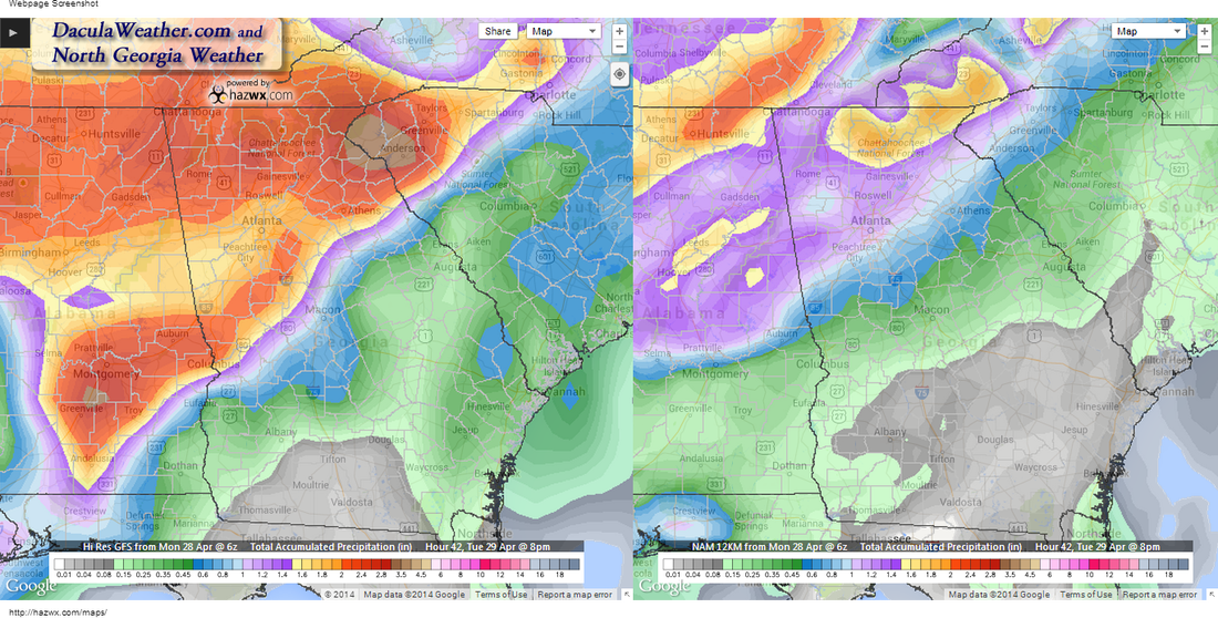
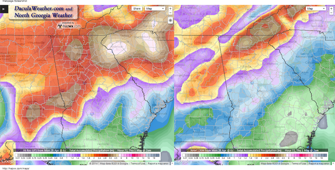
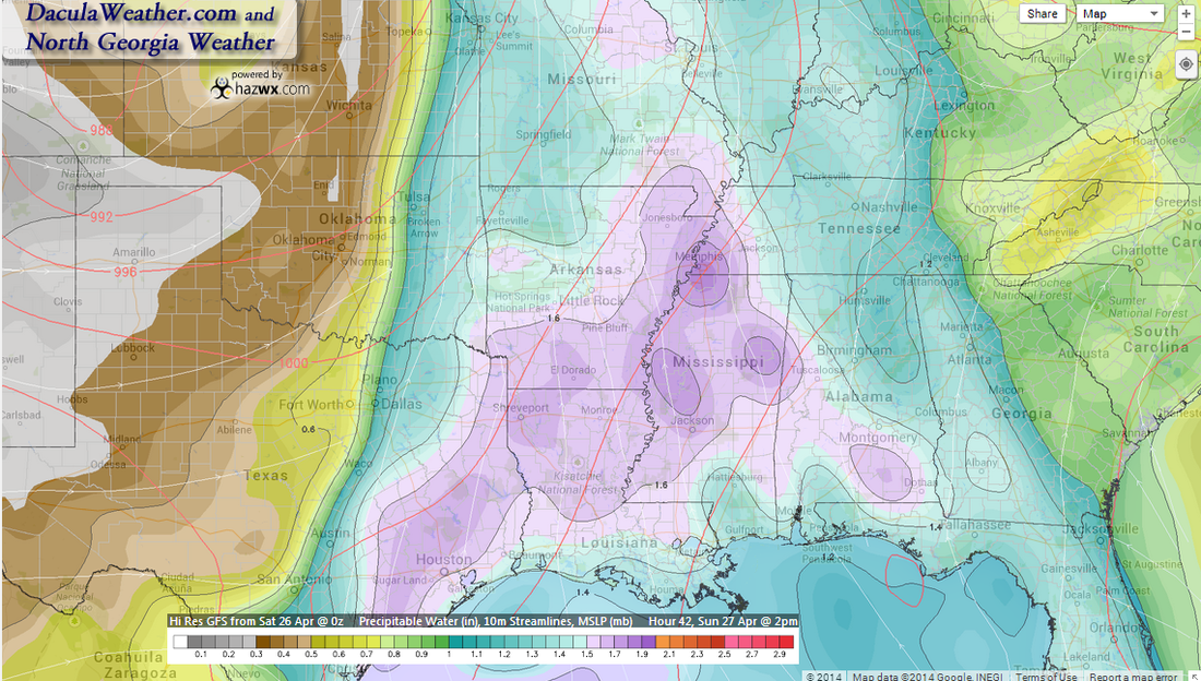
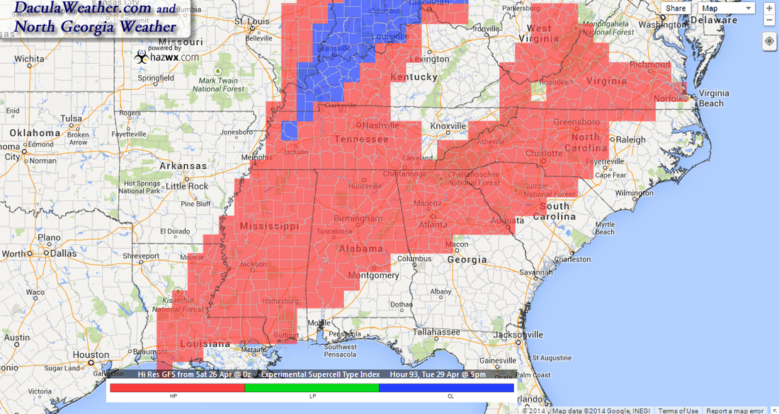
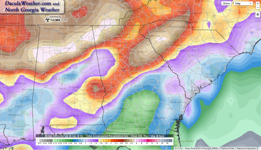
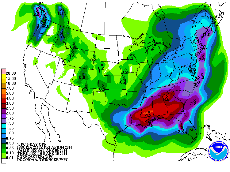
 NOAA Goes East - IR Channel 4 Rainbow loop NOAA Goes East - IR Channel 4 Rainbow loop By now I'm sure that most of you have heard about the severe weather in Arkansas and Oklahoma that killed at least 16 people overnight. It's even sadder to think that these 16 people woke up on a Saturday morning in April, and went about their daily plan, not knowing that their lives would be over later that evening. It's believed that one of those tornadoes may have been an EF5, as at least two homes were wiped clean of the concrete slab. If so, it would be the first EF5 in Arkansas since 1929. The image below depicts the winds and pressures at 11 pm tonight. The image on the left is at 500 mb or roughly 18,000 feet, and the image on the right is at the surface. A few things to note. The upper level low depicted on the left, is sitting right on the border of IA, NE, KS, and MO, whereas this morning it was sitting over the heart of Nebraska. This low is forecasted to very slowly drop east-southeast before pulling northeast. That southeast motion brings the highest upper level winds just to our west. With a warm moist flow at the lower levels, and a diverging jet stream overhead, significant lift can occur. bringing large thunderstorms and very heavy rain. The Significant Tornado Parameter's (STP) are quite high today over Mississippi, Tennessee, and parts of Kentucky and Alabama. This area shifts to the east as the day goes on, but the STP index drops lower as it progresses. The next two maps show the probability of the STP index being =>3. The first image is current, the next image is for Tuesday around 5 pm. What this means is that the likelihood of a widespread tornado outbreak over our area is not nearly as high as it is to our west today. By 4pm today, we're actually starting to get in on some of the shear and helicity that people to our west will be experiencing throughout the day. Helicity tells a meteorologist how much rotation may be present in the atmosphere. The stronger the shear, and the more the wind speeds increase with height, the higher the helicity. Rainfall amounts are going to push our stream and river levels into flood stage most likely. Be alert to ponding on the roadways as you travel and don't drive into standing water unless you know it's safe. The NAM and the GFS differ on how much rain will fall between today and tomorrow at 8pm, this is the GFs on the left and the NAM on the right. The 2nd image is at 2am Thursday after most of the precip is over. Who is going to win? 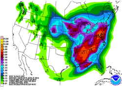 WPC 5 Day Accumulated Precip Forecast WPC 5 Day Accumulated Precip Forecast The WPC has much more information on the rainfall potential in the morning QPF discussion, but here is a excerpt from it: "OROGRAPHIC EFFECTS ARE EXPECTED TO FURTHER ENHANCE THE EXCESSIVE THREAT ACROSS PORTIONS OF NORTHERN GA..UPSTATE SC AND WESTERN NC -- WHERE 3-5 INCH TOTALS CAN BE EXPECTED BEFORE THE EVENT ENDS." The entire discussion can be read here. So for now, be aware and stay alert and make sure you have a working weather radio and multiple ways of receiving weather alerts. Also, if you don't have helmets for you and your family, please get one, they are one of the most effective means of protecting your head in case of a tornado. I will be posting from both Twitter and Facebook as things get going, I'll keep you updated every step of the way. Below is a video taken right after the tornado struck Mayflower Arkansas yesterday. 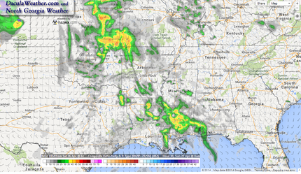 NAM 4km Simulated Radar 8am Sunday NAM 4km Simulated Radar 8am Sunday Beginning Sunday, we are going to be in for a prolonged rainy wet period, possibly all week long, interspersed with severe weather along the way. After a chilly start, today will be beautiful day with sunny skies and temperatures hitting 80 degrees. Sunday will be a repeat for the most part, but moisture will be on the increase starting Sunday morning, and showers and thunderstorms will already be breaking out over portions of the southeast. By 2pm, precipitable water values of more than 1" will creep into our area and the showers will begin to creep into portions of western Georgia as the late afternoon and evening progresses. Monday won't be too bad of a day with temperatures skyrocketing to the low to mid 80's on a flow of warm moist air from the Gulf of Mexico, with only a slight chance for showers during the day. By Tuesday, the possibility of severe weather will be in the forecast, and this severe potential will last through late Wednesday. And as it is now, the Euro is now showing a return of deeper moisture on Thursday and Friday, so don't put up the umbrella yet. To quote Jimmy Buffet: "Where I go, I hope there's rum! Not to worry, Monsoon come..." SevereBeginning Monday night, the dynamics begin to change a little, and the National Weather Service office here in Atlanta had this to say: ANOTHER CONCERN WILL BE SEVERE THUNDERSTORM POTENTIAL AHEAD OF THE FRONT AS LOW LEVEL SHEAR INCREASES STARTING AS EARLY AS MONDAY EVENING OVER N GA AND EVENTUALLY MOVING TO CENTRAL GA TUESDAY NIGHT INTO WEDNESDAY NIGHT. PLENTY OF MLCAPE...VARYING WITH THE HEATING OF THE DAY AND HOW IT ALL PLAYS OUT WILL NEED TO BE MONITORED. We're still in the 4-8 Day outlook range for the Storm Prediction Center, so we'll have better details as we get a little closer, but here is what they had to say this morning. Severe weather potential begins for us around mid-day on Tuesday, and the metro area is in an area that has the potential for High Precipitation (HP) Supercells, according to the HazWx experimental Supercell Type index model. This potential will last through late Wednesday afternoon before the threat lessens. The timing of impulses rotating around the big upper level trough with the heating of the day, will help to determine what precipitation falls where, and trying to pinpoint those is rather difficult to impossible this far out. We'll have to wait to see how those details play out. Right now it looks like Tuesday through Tuesday night will be the most likely time for severe weather here. PrecipitationThis will be a very slow moving system, and with that comes the potential for large amounts of rainfall over a wide area, and the Atlanta NWS is calling for a widespread 3" over north and most of central Georgia. The NWS Weather Prediction Center describes the system like this in their QPF Discussion: A SIGNIFICANT LARGE SCALE PRECIPITATION EVENT IS EXPECTED TO DEVELOP ACROSS THE CENTRAL U.S. SUN-TUE, AS A VIGOROUS SHORTWAVE MOVING INTO SOUTHERN CA THIS MORNING ASSUMES A NEGATIVE TILT AND LIFTS OUT INTO THE CENTRAL PLAINS BY SUN AFTERNOON, WITH A STRONG SURFACE LOW DEEPENING IN THE LEE OF THE COLORADO ROCKIES THAT GRADUALLY LIFTS NORTHEASTWARD INTO THE CENTRAL PLAINS. THE ENTIRE STORM SYSTEM WILL SLOW...HALTED BY DOWNSTREAM RIDGE WITH A HIGH BUILDING SOUTH OF HUDSON BAY. THE GULF OF MEXICO WILL BE COMPLETELY OPEN WITH ANOMALOUS PWS SURGING NORTHWARD THROUGH THE MS VALLEY BEFORE SHIFTING EAST INTO THE OH AND TN VALLEYS. With all of the expected rainfall, we have to be mindful of flash flooding. The NWS issues flash Flood Guidance maps that depicts how much rainfall has to fall over a given period of time in order to create Flash Flood conditions. I have a new Flash Flood guidance page, and one page was just modified. The NWS didn't call me up to tell me they were changing images :-) so the old page wasn't working correctly. The new page is an interactive Flash Flood Guidance page.
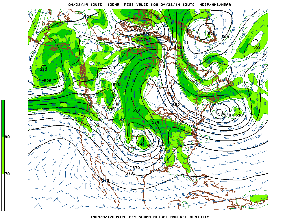
As always, these pages look and work best using Google Chrome, Safari, or Firefox. and hope everyone likes the new maps that I'm able to bring you from HazWx! Have a GREAT weekend and enjoy the beautiful weather while you can! 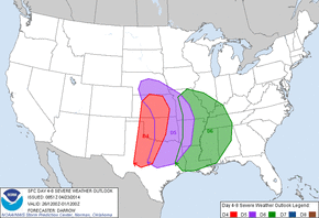 The likelihood of severe weather has been on the increase for this weekend and early next week, and it's something we are going to start watching and getting you prepared for. The Storm Prediction Center has started issuing some strongly worded discussions about the severe weather potential for this weekend into early next week, and especially this far in advance. It appears that much of the really severe weather may stay a little further west and north of our area, but there is still plenty of time for things to change. From this mornings 4-8 day forecast discussion from the SPC: DAY 4-8 CONVECTIVE OUTLOOK Quite a few experienced meteorologists are expressing their concern about the severe potential, this Tweet is from Reed Timmer, probably the most well known storm chaser in the United States. 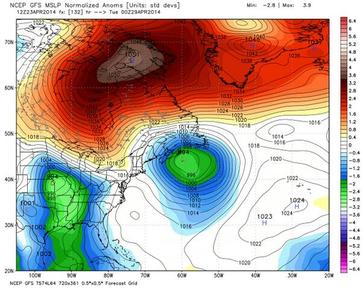 NAO Block in Orange NAO Block in Orange It appears that beginning Sunday, the pattern across the entire country will be changing, placing us in the cool wet area that may last for a little while. Things are looking very similar to the way it did this winter with a ridge over Alaska, but one big change. We are getting ready to experience what we wished we had, but never really saw over the winter... a negative NAO. The NAO is the North Atlantic Oscillation, a large scale atmospheric blocking regime that occurs when a ridge of high pressure sets up near Greenland. In the winter time, this block helps to keep the cold air bottled up over the continental US, versus pushing off to the Atlantic ocean. We really haven't had a significant NAO- since last October. Dr. Ryan Maue said this about his image from Weatherbell.com: "GFS 12z huge surface High over NE Canada in 5 days blocking everything. 1051 mb". What that means, is that whatever cold air pushes south, gets locked in place for a while. Welcome summer... 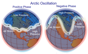 On top of that, the AO or Arctic Oscillation, is also going negative.... having both negative at the same time is a double bonus... and absolutely what we wanted over the winter. So we finally get double blocking and it's almost summer time. Go figure. Here's an image of the AO and how the different phases imply different weather conditions for us here in the southeast. Again, this double block means a slow to leave, wet, and cool period across the southeast for while. When the AO index is negative, there tends to be high pressure in the polar region, weaker zonal winds, and greater movement of frigid polar air into middle latitudes. In the positive phase, higher pressure at mid-latitudes drives ocean storms farther north, and changes in the circulation pattern bring wetter weather to Alaska, Scotland and Scandinavia, as well as drier conditions to the western United States and the Mediterranean. 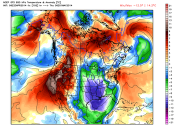 After the severe weather on Monday/Tuesday, temperatures will drop behind the front with very cool temps for this time of year, with the start of May much like last year with very cool anomalies. You'll notice from looking at this map, that high pressure keeps the cooler air bottled up to the south and east parts of the county. 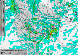 This is map of the vertical velocities on Tuesday. This gives you an idea of the lift in the atmosphere, and as you can see, there is fairly significant lift in association with the upper low. It appears that other severe weather parameters also indicate a severe weather event for us here. Please stay tuned for more updates on this upcoming event, and make sure that you and your family has a severe weather plan in place BEFORE severe weather strikes. 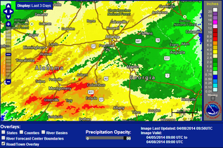 Well, I hope everyone enjoyed the rain yesterday. OK... so Sunday was dry, the weatherman got it wrong. But they sure got it right yesterday with many areas still under Flash Flood Warnings. As of this morning, there was still one gauge in Moderate flooding, 23 in Minor, and 53 near flood stage across the southeast. Close to us, Suwanee Creek, Big Creek near Alpharetta, and the Middle Oconee River near Arcade are still in Flood Stage. I ended up with a total of 3.08" from this system. My 7 year average for April is 3.80", so I got pretty close to my monthly total in about 24 hours. Some areas in Alabama got crushed by heavy rain with some areas receiving 6-8". If you compare the actual rainfall map to the left, to the predicted map to the bottom, you can see the forecasted placement was spot on. 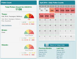 Brought to you by the Atlanta Allergy and Asthma Clinic Brought to you by the Atlanta Allergy and Asthma Clinic The pollen count today is 1156... Brought to you by the Atlanta Allergy and Asthma Clinic It's looking nice from Thursday through the weekend, and starting Thursday, temps will rebound back into the 70's and remain that way all the way through Sunday.
Enjoy the weather... |
Archives
March 2019
Categories
All
|
OLD NORTH GA WX BLOG
 RSS Feed
