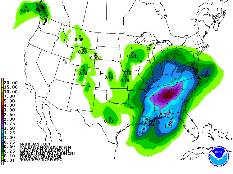
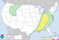
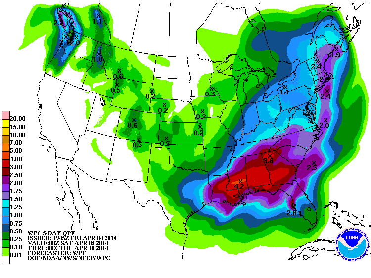
 Click for full size image (Mon-Tue precip) Click for full size image (Mon-Tue precip) Today was most certainly a dud, but again, it was anticipated that the upper air dynamics would be moving off to the northeast and taking the rain along with it. But the next system in line is going to be a very different story. A very substantial rainfall is in the cards for the southeast as you can see from these couple of images. Rain will begin on Sunday but Monday will most likely have the heaviest rainfall. The Atlanta NWS says 2-3" may fall and the Storm Prediction Center had this to say this morning in the 4-8 day outlook discussion:
The Atlanta National Weather Service office said this about it in their afternoon discussion. There is still a chance for severe weather as you can see from the discussion below. .LONG TERM /SUNDAY THROUGH FRIDAY/... So keep the umbrella handy beginning Sunday, and then maybe a rainsuit for Monday. :-)
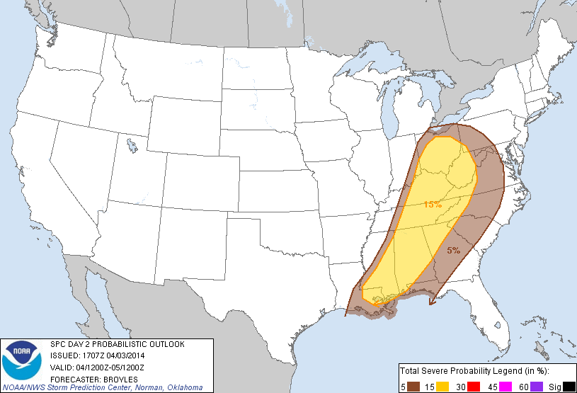
 Some very rough weather over Missouri today, with some very large hail as well as several tornadoes. This area continues to push east and will be arriving here tomorrow, but in a much weaker state. The Storm Prediction Center has placed us in a Slight Risk area for tomorrow, and I believe that for us, that will be later in the afternoon. In their 12 noon Day 2 Outlook Discussion, they outline how they believe this will play out over the southeast as the day goes on tomorrow. Our biggest threat will be strom damaging winds, but a tornado can't be ruled out.
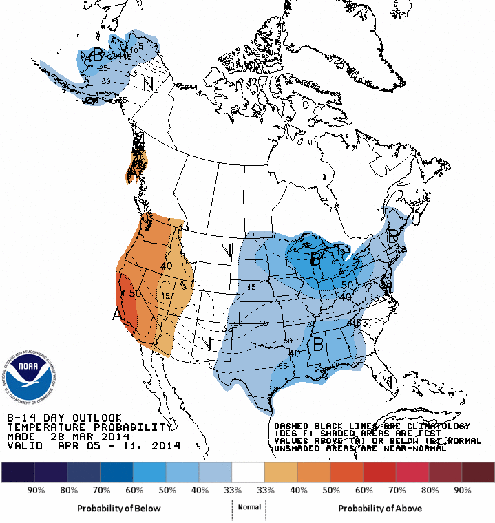
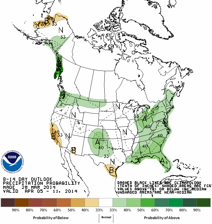
As I alluded to in my morning post, signs are pointing toward a cool down about the 2nd week of April, after the nice warm up this week. Over the winter the MJO had little influence due to the overwhelming signals from the warm north Pacific, but now that winter is over (of course) its influence begins to emerge. This Tweet from Joe Bastardi tells that story. This morning, Don Sutherland has this to say about the potential upcoming pattern. The first sentence is in reference to the big storm that brushed the NE coast the other day: That energy-transfer process is forecast to continue over the next 6-12 hours by the GFS with the system being fully absorbed afterward. In response to the developments that will be occurring south of Greenland, weak ridging over Greenland could be enhanced, helping increase the prospects for a period during which the NAO goes neutral or negative in coming days, especially as the AO will also likely be going neutral or negative. Don is talking about the potential blocking that is forecast to occur in the wake of the departing storm system. Robert at WXSouth.com also pointed out that April is THE month for cut-off lows to develop and next weekend maybe one of those situations, time will tell. 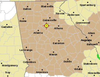 While I'm talking weather, our area is under a Wind Advisory until tomorrow evening. All of our alerts, watches and warnings can be found here. URGENT - WEATHER MESSAGE 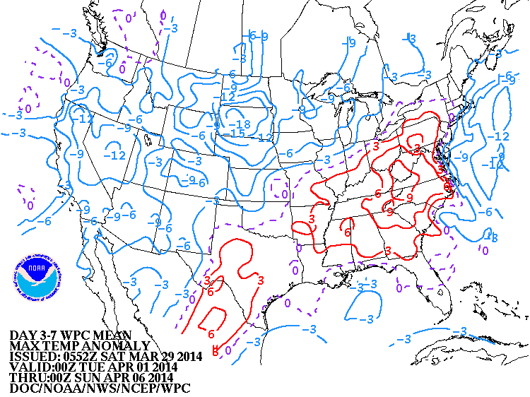 Other than a few showers today, our weather for the next 5-6 days should be routinely tranquil. The rain that we were to get today is fizzling out as it approaches the metro area, so I don't think we'll see too much at all. That's twice now that the convection in the Gulf has cut off the moisture flow to our area. Temperatures start off cool for Sunday, and we will have some pretty brisk winds to go along with the mid 60's temps, but beginning Monday, temps rebound nicely into the mid 70s where they should stay for most of the work week. The end of the week brings a chance for severe weather with diverging solutions on the exact scenario that will play out. But as it looks now, I would be on alert toward Friday and Saturday for that severe potential. When we're this far out, I like to read the Weather Prediction Center's (WPC) Extended Forecast Discussion. They always contain valuable information about the behind the scenes thoughts about what is going to happen. Here's a little excerpt from today's discussion: ..OVERVIEW... 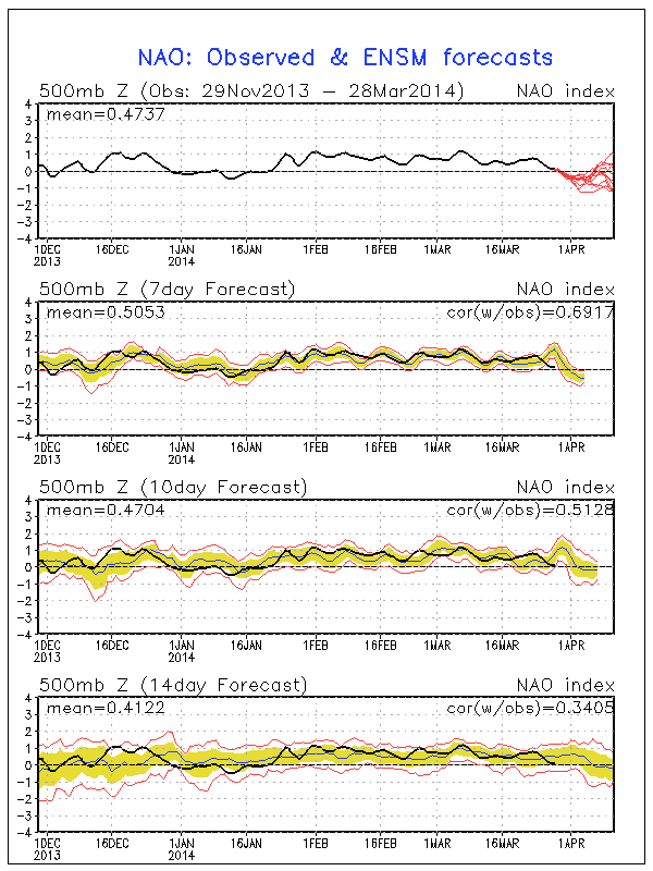 There has also been talk about the North Atlantic Oscillation (NAO) taking a turn toward a negative state, which may imply a delayed spring, much like last year. If you remember, April, May, and even June were pretty cool in 2013 also. I'll take the cool weather any day, over the 90 degree blast furnace temperatures of summer. It also appears the Arctic Oscillation (AO) may be going negative, which would mean the combination of the two would bring cooler temps to the eastern half of the county. The Climate Prediction Center is showing below normal temperatures and above normal precipitation for the southeast over the next 8-14 days, but they have low confidence in their forecast at this point. We'll just have to wait and see how the pattern evolves. FORECAST CONFIDENCE FOR THE 8-14 DAY PERIOD IS: MUCH BELOW AVERAGE, 1 OUT OF 5, DUE TO FAIR AGREEMENT BETWEEN THE ENSEMBLE MEAN SOLUTIONS, OFFSET BY LARGE RUN-TO-RUN VARIABILITY AMONG DETERMINISTIC SOLUTIONS, UNCERTAINTY ASSOCIATED WITH A LOW-AMPLITUDE, SPLIT-FLOW PATTERN, AND DISAGREEMENT AMONG THE HIGHER SCORING TOOLS.
|
Archives
March 2019
Categories
All
|
OLD NORTH GA WX BLOG
 RSS Feed
|
Never base important decisions on this or any weather information obtained from the Internet. Always have a backup method of receiving weather information such as a battery powered weather radio.
Copyright © 2018 NorthGeorgiaWX.com and DaculaWeather.com 
|