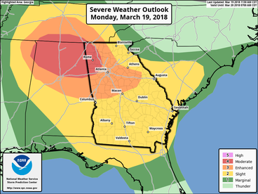
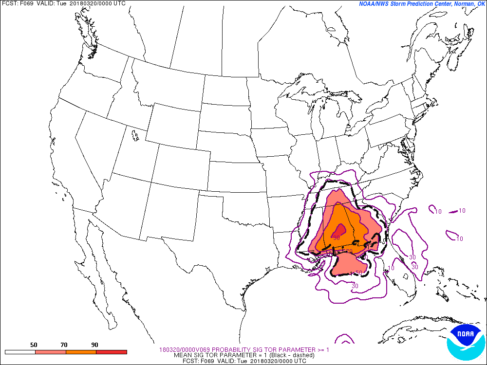
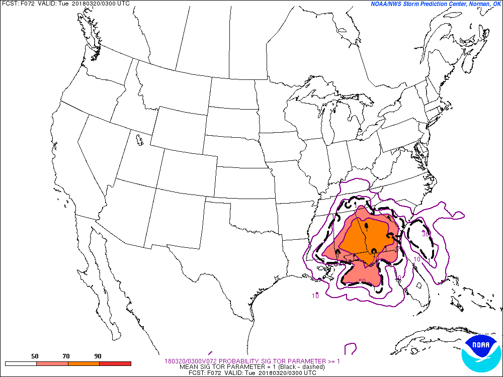
 Here are the slides from the latest severe weather briefing. First, the SPC discussion ...SUMMARY... Strong tornadoes, very large hail, and damaging winds are expected across parts of the Tennessee Valley and Southeast during the late afternoon and evening. ...TN Valley and Southeast... Have upgraded to Moderate risk for the increasing likelihood of several tornadic supercells between 21-03Z, centered on northern AL and portions of adjacent states. Expansions to Enhanced and Slight risks have also occurred across parts of GA and SC for this evening and tonight. Lowest confidence remains on northern extent of the strong tornado risk where the degree of surface-based destabilization is quite uncertain. An elevated storm cluster is ongoing across far northern MS to the Mid-MS Valley, still removed from appreciable surface-based instability that is present near/south of the warm front in north-central MS/AL. See MCD 144 for additional short-term information. Guidance is highly varied in the degree of warm front movement today, which may be in part explained by differences in the handling of the ongoing convection. The NAM robustly destabilizes into middle TN but has a distinct absence of convective precip where convection is ongoing. While the RAP has substantially less buoyancy in TN with SBCAPE >500 J/kg remaining largely south of the state border. While low/deep-layer shear and hodograph size will become increasingly favorable for rotating storms, confidence in the degree of northward destabilization in the late afternoon across TN is low. However, farther south in parts of MS/AL/GA, confidence is greater in moderately large buoyancy developing with MLCAPE of 1500-2500 J/kg becoming common south of the warm front. The northern extent of this instability plume with enlarged low-level hodographs should render the potential of several tornadic supercells during the late afternoon and early evening, a couple of which may be long track. Morning CAMs suggest the southern extent of probable supercell development will be across north-central AL, with convection becoming increasingly sparse to the south/southwest. During the evening, convection should become increasingly clustered/semi-discrete, but a risk for a few strong tornadoes should continue across parts of northern/central GA near the warm front. Damaging wind/tornado risk should persist but become increasingly localized across parts of SC tonight.    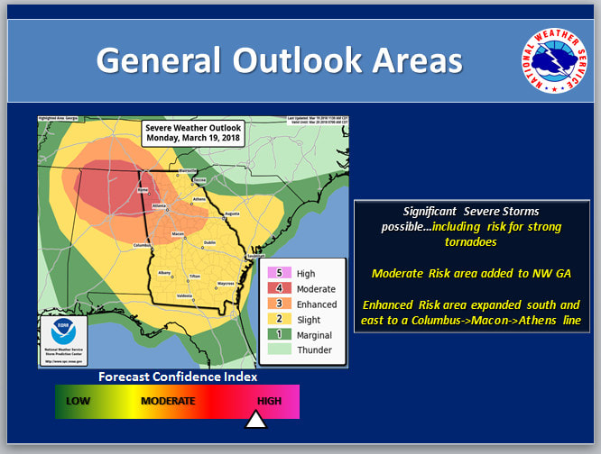 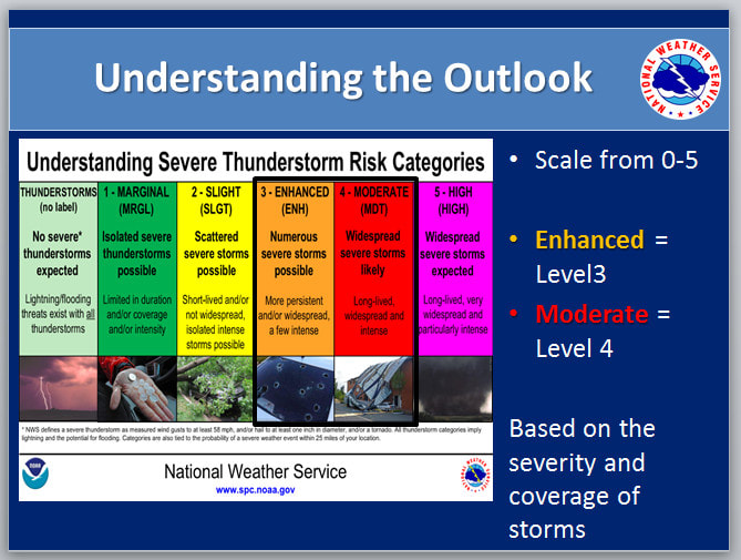 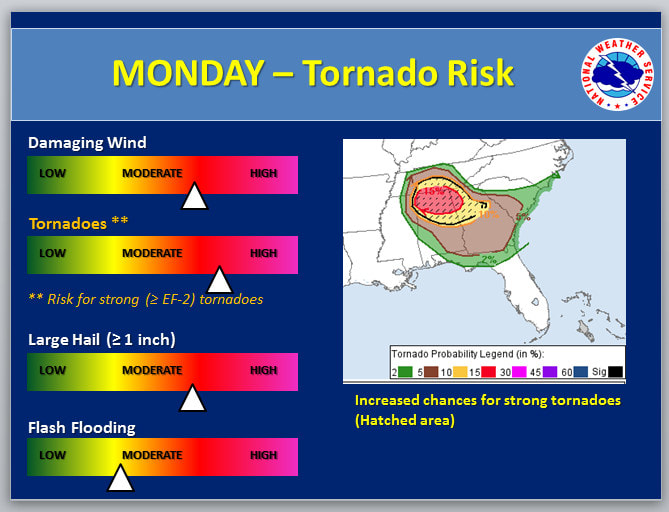 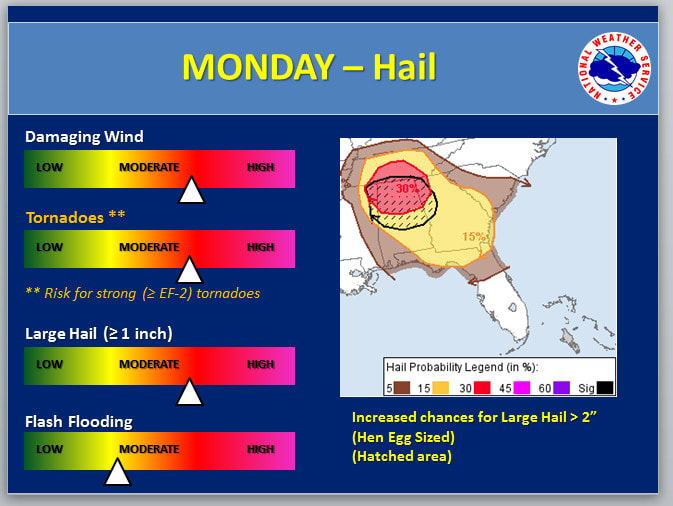 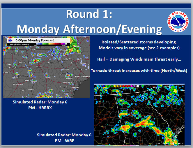 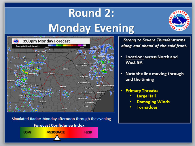 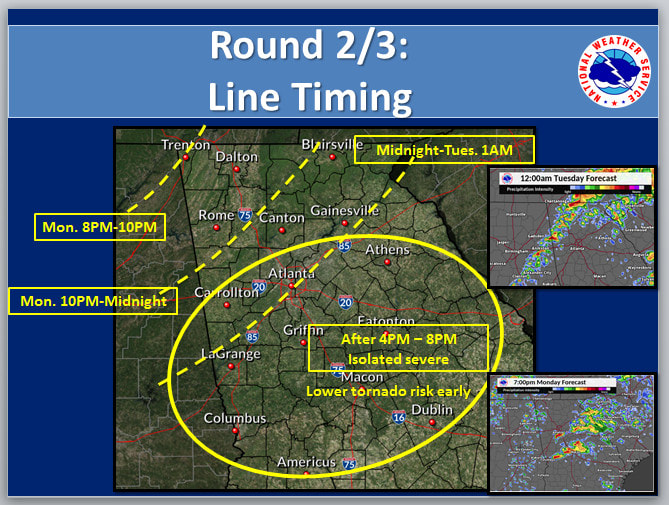  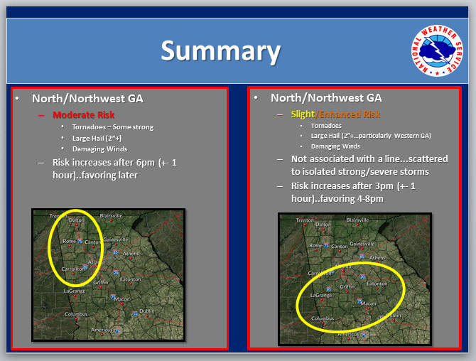 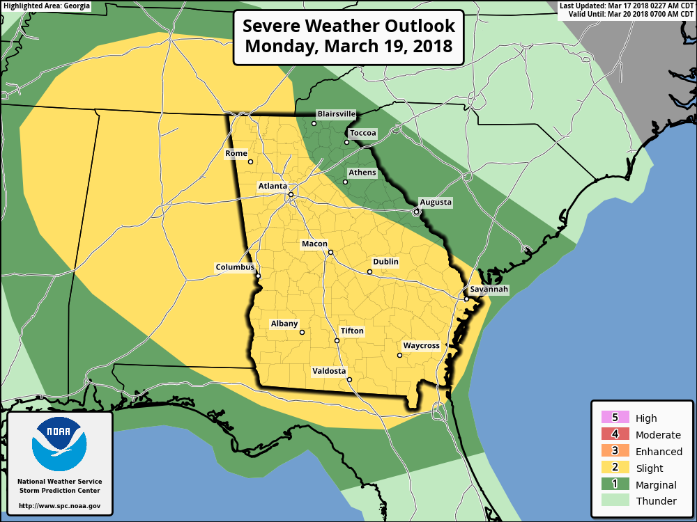 Severe Weather Outlook - Monday March 19 Severe Weather Outlook - Monday March 19 A severe weather threat is on the increase for Monday, and while the risk is "Slight", it appears that the Storm Prediction Center may consider raising that threat level to "Enhanced". NWS Atlanta talked about the event in their AFD this morning: "Instabilities increase during the day Monday with muCAPE increasing into the 800-1800j/kg range and shear and lapse rate values staying up as well. There is not as much deep moisture present but with a secondary cold front sweeping around the parent low and daytime high temps in the 60's and 70's... the atmosphere will be primed for severe storms to develop. SPC also agrees and has placed the majority of the state under a slight risk for day 3 with NW and west central GA under a 10 percent hatched area for significant severe weather. Will be keeping a close eye on this over the next few days" The following is from the Storm Prediction Center, the bold are my highlights:  Day 3 Convective Outlook NWS Storm Prediction Center Norman OK 0227 AM CDT Sat Mar 17 2018 Valid 191200Z - 201200Z ...THERE IS A SLIGHT RISK OF SEVERE THUNDERSTORMS ACROSS MUCH OF AL... GA... SOUTHERN TN... AS WELL AS NORTHERN FL AND NORTHEAST MS... ...THERE IS A MARGINAL RISK OF SEVERE THUNDERSTORMS ACROSS MUCH OF THE SOUTHEAST... ...SUMMARY... Severe storms capable of tornadoes, damaging wind and hail are possible across parts of Middle Tennessee, Alabama, and Georgia. Severe wind is also possible into northern Florida. ...Discussion... The timing of a shortwave trough will play a critical role in severe potential on Monday across TN, MS, AL and GA. At this time, the NAM appears to be too slow and more amplified with this wave over MO compared to the ECMWF and GFS which show it over central KY or Middle TN at 00Z Tuesday. As a result, severe potential looks quite different amongst the models. For example, the latest NAM shows an extremely volatile setup over middle TN and northern AL clearly favoring strong tornadoes. However, the most likely solution appears to be a blend of the ECMWF and GFS, both showing a faster and lower-amplitude shortwave, as well as less low-level shear with relatively veered 850 mb flow. The most probable scenario appears to be for isolated, potentially significant severe storms from Middle TN into northern AL and GA, dependent on how much destabilization occurs especially in TN. Models also indicate substantial storm coverage across much of southern GA into northern FL, possibly in the form of an MCS, with mainly wind damage potential given unidirectional flow. Given the potential for significant severe storms, a categorical upgrade is possible in later outlooks once predictability increases and the centroid of severe coverage is better established. ..Jewell.. 03/17/2018 CLICK TO GET WUUS03 PTSDY3 PRODUCT NOTE: THE NEXT DAY 3 OUTLOOK IS SCHEDULED BY 0730Z The threat that people are most concerned about are tornadoes, and these storms will be capable of generating tornadoes. The two images below are showing the SigTor parameter (significant tornado) >=1 between 7pm - 10pm Monday.
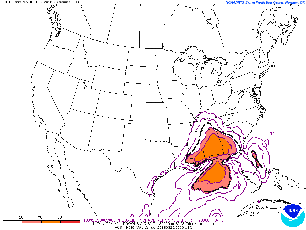
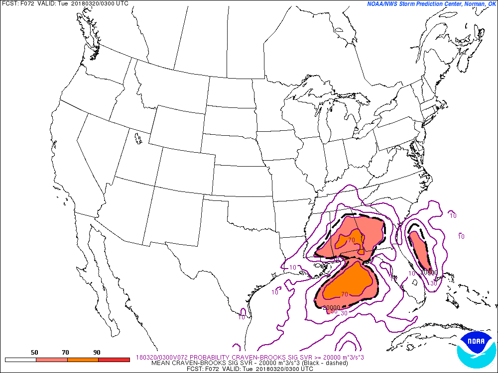
Another parameter to look at is the Craven-Brooks Significant Severe. According to the SPC, using a database of about 60,000 soundings, the majority of significant severe events (2+ inch hail, 65+ knot winds, F2+ tornadoes) occur when the product exceeds 20,000 m3/s3, and the following two images depict that area of 20,000 or higher within the dashed black lines. These images are also 7 pm and 10 pm.
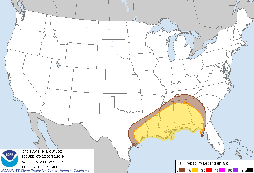
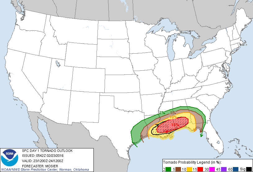
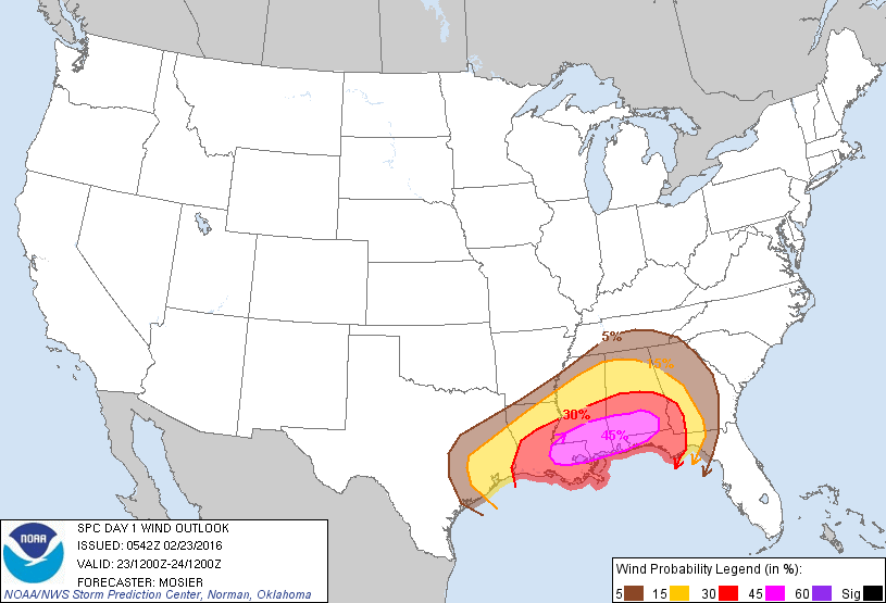
We are still several days away so there will be changes, so be sure follow https://www.facebook.com/NorthGeorgiaWeather for the latest updates. An update to the event that will be unfolding today. For us, most of the severe will come after midnight tonight, so please be sure to have a weather radio handy, as night time is always the worst time for weather like this. The darkness makes it almost impossible to spot tornadoes, and the type of tornadoes that spin with systems like these are quick and not often seen on a radar. For most of north and northeast Georgia, wind damage will be the biggest threat. Screaming winds just above the surface can mix down in any thunderstorm and bring high winds to ground level, and one way quick spin up tornadoes develop. This from the Storm Prediction Center in the their Day 1 Severe Weather Outlook ...SUMMARY... SEVERE THUNDERSTORMS CAPABLE OF DAMAGING WINDS AND TORNADOES WILL BE LIKELY OVER PORTIONS OF THE GULF COAST STATES TUESDAY. A FEW OF THE TORNADOES MAY BE STRONG...ESPECIALLY TUESDAY AFTERNOON AND INTO TUESDAY NIGHT. And this from the Atlanta NWS office... SHORT TERM /TODAY THROUGH WEDNESDAY/... 
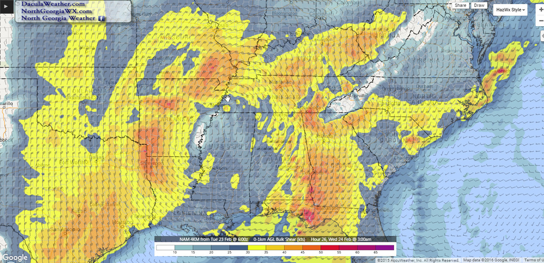
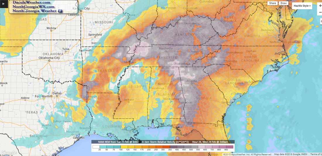
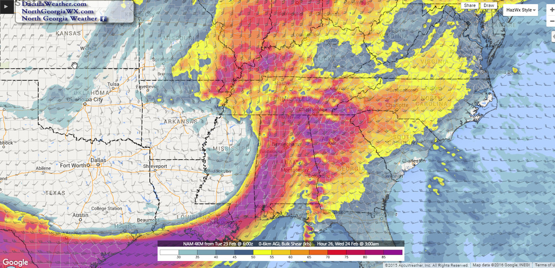
  NOAA Goes East - IR Channel 4 Rainbow loop NOAA Goes East - IR Channel 4 Rainbow loop By now I'm sure that most of you have heard about the severe weather in Arkansas and Oklahoma that killed at least 16 people overnight. It's even sadder to think that these 16 people woke up on a Saturday morning in April, and went about their daily plan, not knowing that their lives would be over later that evening. It's believed that one of those tornadoes may have been an EF5, as at least two homes were wiped clean of the concrete slab. If so, it would be the first EF5 in Arkansas since 1929. The image below depicts the winds and pressures at 11 pm tonight. The image on the left is at 500 mb or roughly 18,000 feet, and the image on the right is at the surface. A few things to note. The upper level low depicted on the left, is sitting right on the border of IA, NE, KS, and MO, whereas this morning it was sitting over the heart of Nebraska. This low is forecasted to very slowly drop east-southeast before pulling northeast. That southeast motion brings the highest upper level winds just to our west. With a warm moist flow at the lower levels, and a diverging jet stream overhead, significant lift can occur. bringing large thunderstorms and very heavy rain.  500 mb Winds left, Surface winds right - 11pm Monday night. The Significant Tornado Parameter's (STP) are quite high today over Mississippi, Tennessee, and parts of Kentucky and Alabama. This area shifts to the east as the day goes on, but the STP index drops lower as it progresses. The next two maps show the probability of the STP index being =>3. The first image is current, the next image is for Tuesday around 5 pm. What this means is that the likelihood of a widespread tornado outbreak over our area is not nearly as high as it is to our west today. 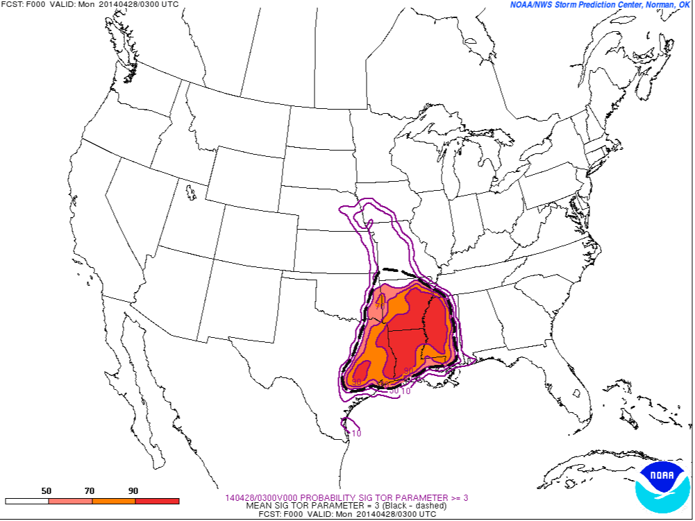 Significant Tornado Parameter >=3 Monday 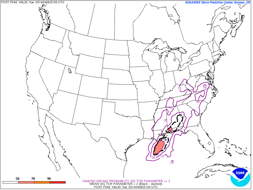 Significant Tornado Parameter - >=3 Tuesday By 4pm today, we're actually starting to get in on some of the shear and helicity that people to our west will be experiencing throughout the day. Helicity tells a meteorologist how much rotation may be present in the atmosphere. The stronger the shear, and the more the wind speeds increase with height, the higher the helicity. 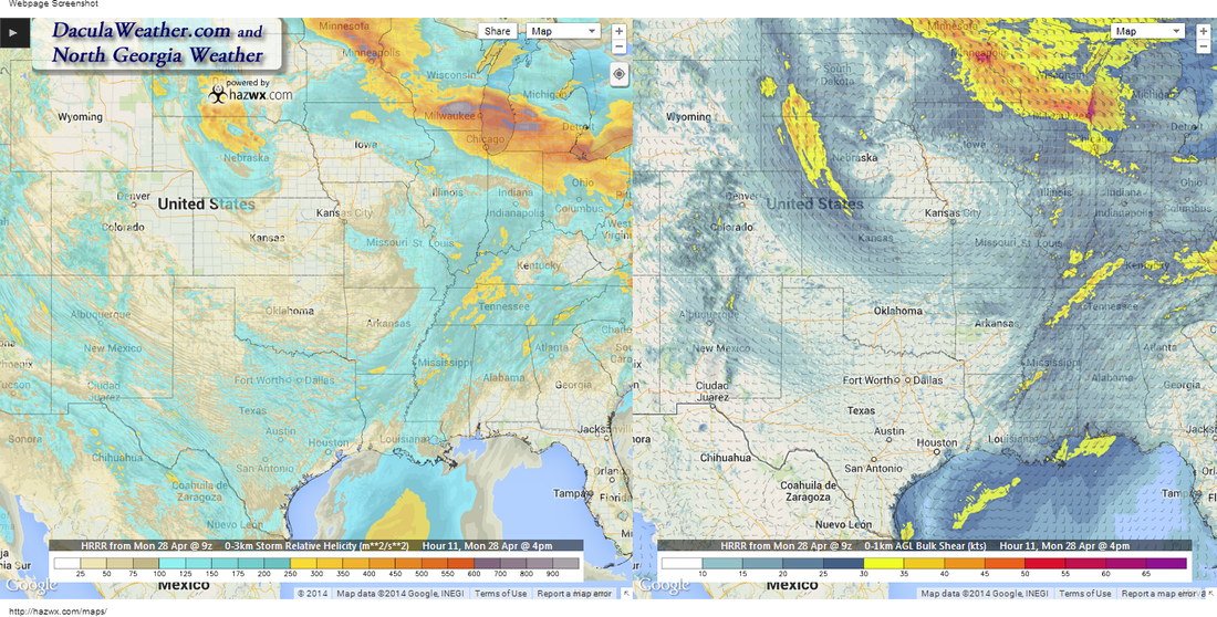 Helicity on left, Shear on right - 4pm Monday Rainfall amounts are going to push our stream and river levels into flood stage most likely. Be alert to ponding on the roadways as you travel and don't drive into standing water unless you know it's safe. The NAM and the GFS differ on how much rain will fall between today and tomorrow at 8pm, this is the GFs on the left and the NAM on the right. The 2nd image is at 2am Thursday after most of the precip is over. Who is going to win? 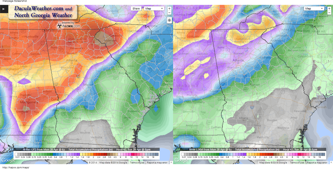 Rainfall Totals - 8pm Tuesday 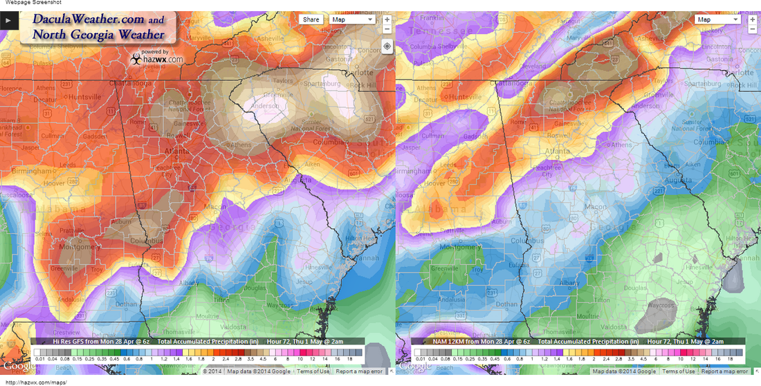 Rainfall Totals - 2am Thursday 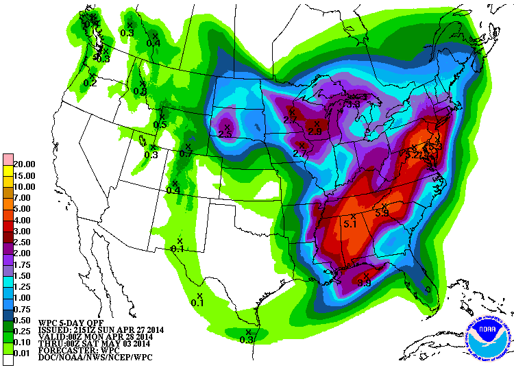 WPC 5 Day Accumulated Precip Forecast WPC 5 Day Accumulated Precip Forecast The WPC has much more information on the rainfall potential in the morning QPF discussion, but here is a excerpt from it: "OROGRAPHIC EFFECTS ARE EXPECTED TO FURTHER ENHANCE THE EXCESSIVE THREAT ACROSS PORTIONS OF NORTHERN GA..UPSTATE SC AND WESTERN NC -- WHERE 3-5 INCH TOTALS CAN BE EXPECTED BEFORE THE EVENT ENDS." The entire discussion can be read here. So for now, be aware and stay alert and make sure you have a working weather radio and multiple ways of receiving weather alerts. Also, if you don't have helmets for you and your family, please get one, they are one of the most effective means of protecting your head in case of a tornado. I will be posting from both Twitter and Facebook as things get going, I'll keep you updated every step of the way. Below is a video taken right after the tornado struck Mayflower Arkansas yesterday. |
Archives
March 2019
Categories
All
|
OLD NORTH GA WX BLOG
 RSS Feed
|
Never base important decisions on this or any weather information obtained from the Internet. Always have a backup method of receiving weather information such as a battery powered weather radio.
Copyright © 2018 NorthGeorgiaWX.com and DaculaWeather.com 
|