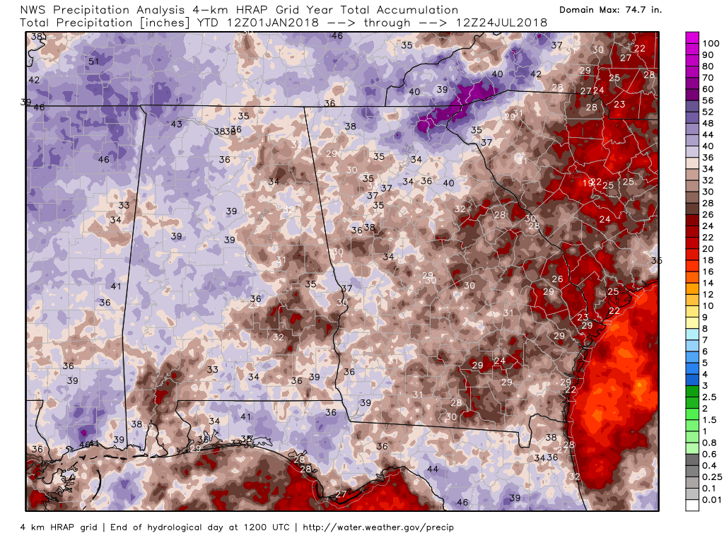
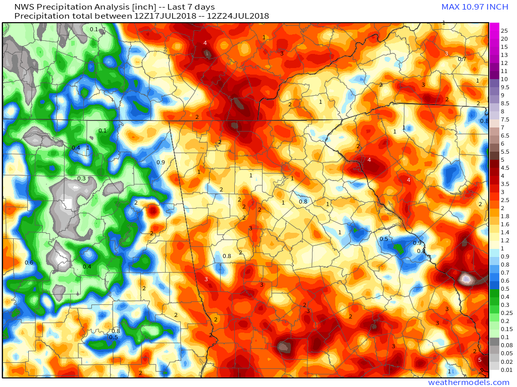
 Year to Date Rainfall Year to Date Rainfall We're almost through a full 7 months of this year, so I thought I'd take a look at the precipitation details for Georgia up to this point. I don't really like looking at specific locations for rainfall as the amounts can vary pretty widely across the area, so for the most part I'll show the state numbers, and then go back and show the data for the various climate locations for the Atlanta NWS forecast area. I've tried to keep it short and sweet and let the images and maps do the talking. In the rows where there are three images, the images from left to right are: Total Precipitation, Amount of Precipitation Above Normal, and the % of Normal Precipitation. The 7 day and 30 day charts include yesterday (up to 8:00 am July 24) in the calculations. Last 7 DaysThe last 7 days have seen some very heavy rain for some areas, and parts of north Georgia have seen up to 300% of their normal for this period.
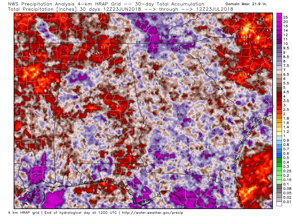
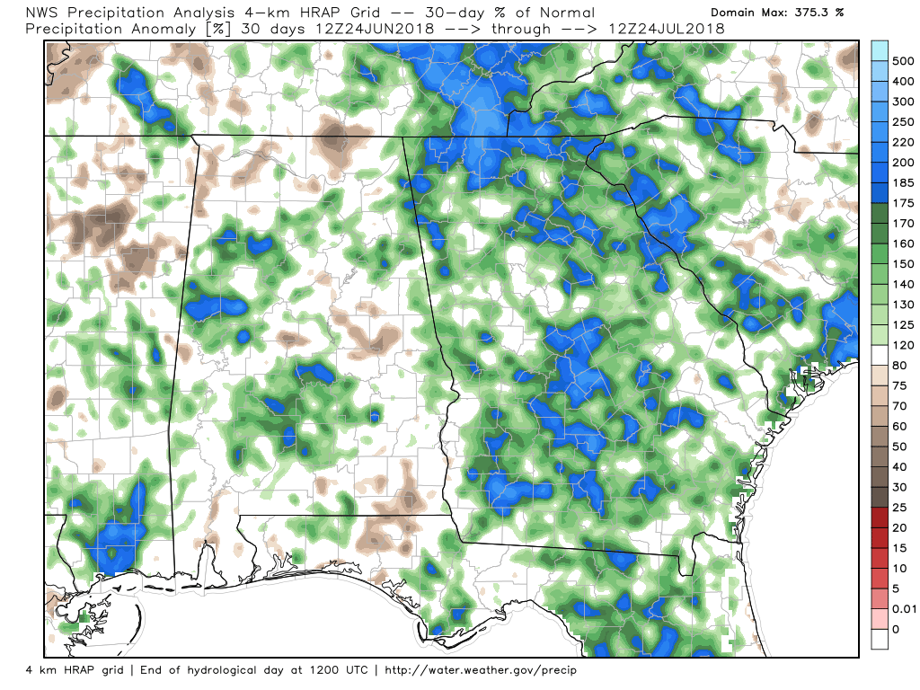
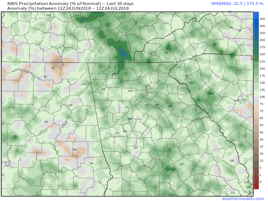
Last 30 DaysThe last 30 days has seen some very beneficial rainfall for all of Georgia. Some areas in the north are running almost 200% above normal for the 30 day period, but the amounts can vary quite a bit depending on where you live.
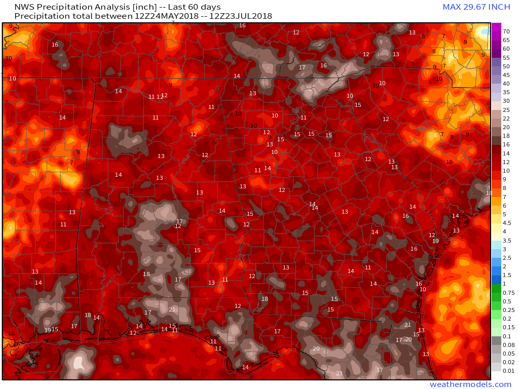
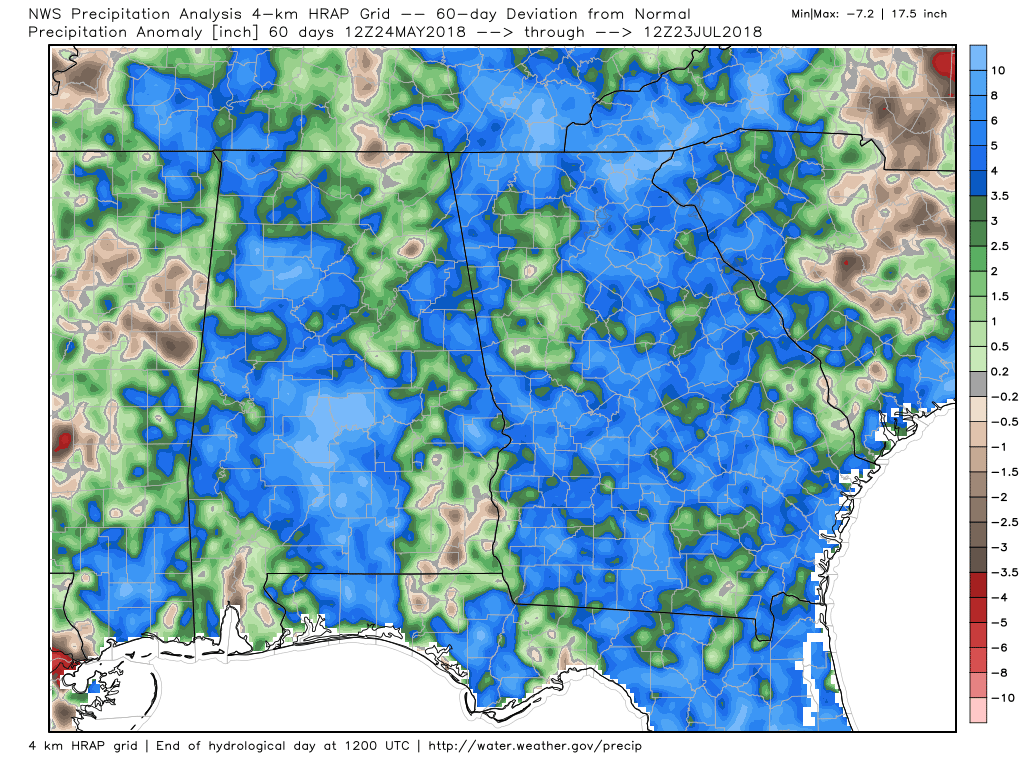
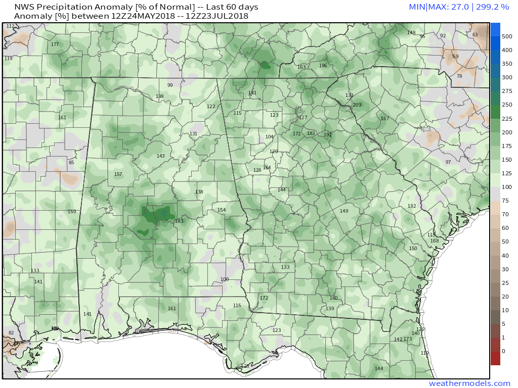
Last 60 DaysNothing very different from the 30 day period. Most every area is running about 3.5" above normal except for the Atlanta area, and Cobb, Douglas, and Fayette, which are normal to an inch or two above normal.
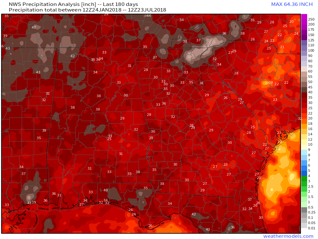
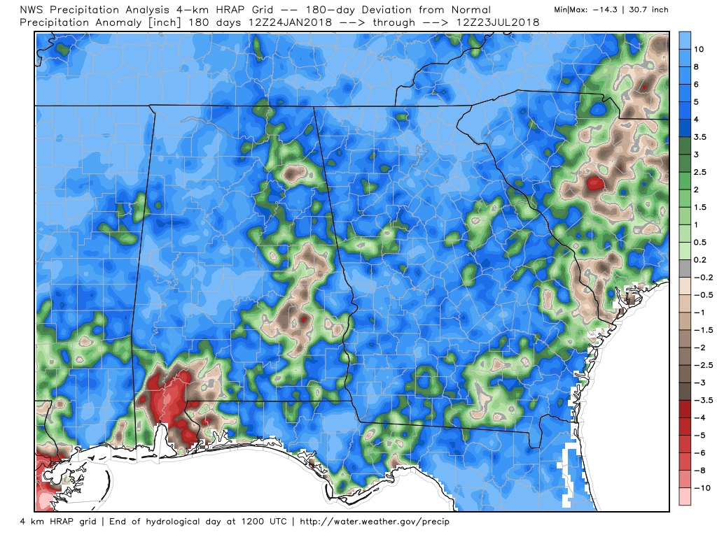
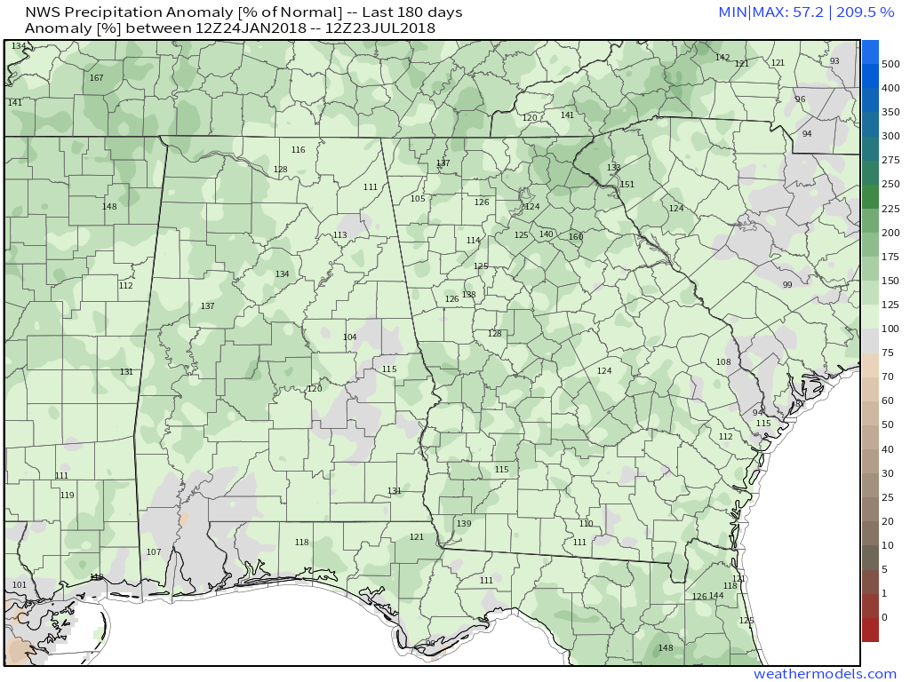
Last 180 DaysThe last 180 days are still running more than 100% above normal with some sites 120-140% above normal. Really no shortage of rainfall anywhere in Georgia.
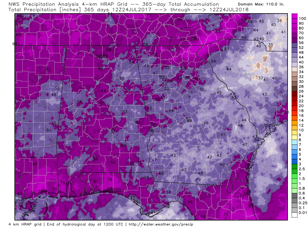
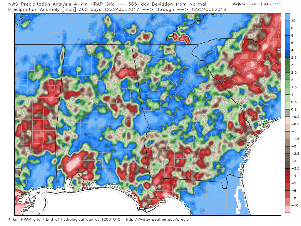
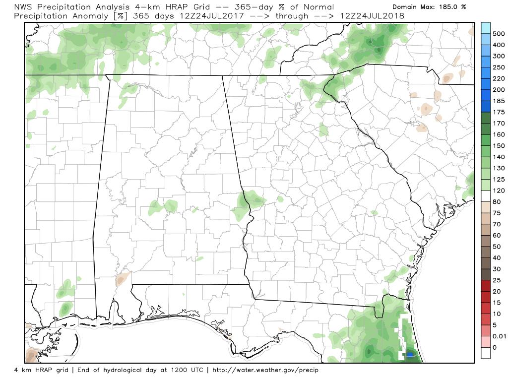
Last 365 DaysAs we go out in time, the anomalies decrease. Here's a look at the last 365 days.
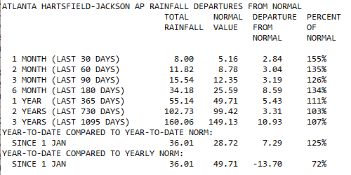
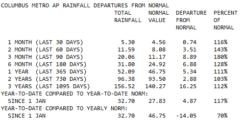
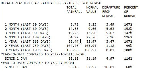
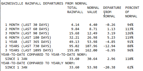
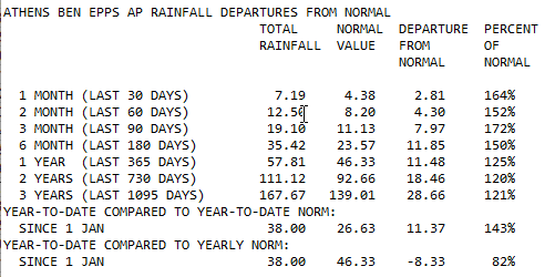
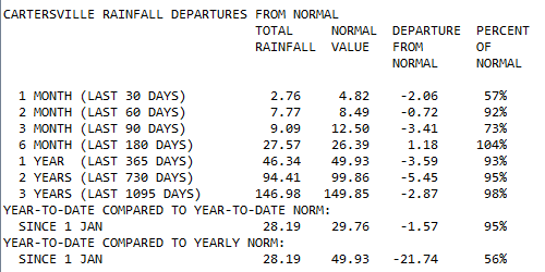
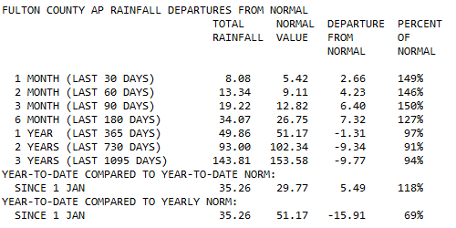
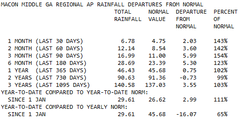
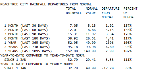
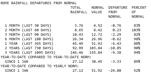
Atlanta Hartsfield One Month Precipitation Totals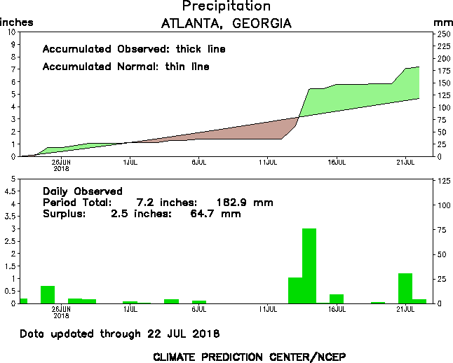 2018 Atlanta Precipitation Precipitation Details for Various Georgia Climate LocationsClick on the images to enlarge
 SPC Day 1 Convective Outlook SPC Day 1 Convective Outlook The Storm Prediction Center has issued a "Moderate" severe weather outlook for today (Friday) for parts of western Tennessee up though Indiana. Since yesterday's forecast from the SPC, all areas of severe risk have been expanded in area and severity. Friday For today, the Atlanta NWS doesn't seem too concerned about the "Slight" risk area over NW Georgia, and here are their comments. "It will take awhile for low clouds to burn off this morning with some guidance indicating early afternoon before we see any degree of clearing. By the time this occurs, deep layer moisture axis will be shunted southward with precipitable water over the Atlanta metro dropping to 1.40 inches by mid afternoon. For these reasons, guidance not all that keen on precip chances for the northern tier keeping most locales at 20 percent or less. Feel it may be a little too low for the metro and too high for Central Georgia where low clouds will hang on a little longer."  Overnight Overnight As we head into the overnight hours things begin to change. Again, comments from the NWS. "Interesting developments this evening and first part of the overnight period as a very strong shortwave for this time of year progresses toward NW GA in overall NW flow aloft. Models has been indicating very little instability to work with as MCS complex approaches but latest are trending more unstable. Up to about 2500 J/KG for the far NW, more than enough to sustain strong to locally severe activity into our area for the evening and first part of the overnight period. Should dissipate as it progresses toward the metro given lower instability but as we saw several weeks ago, these NW flow systems often have a mind of their own." The image below left, depicts the amount of CAPE that will be available. CAPE, or Convective Available Potential Energy, is the measure of the amount of energy available for convection. CAPE is directly related to the maximum potential vertical speed within an updraft; thus, higher values indicate greater potential for severe weather. As you can see for today, there is a wedge of cooler drier air trying to push southwest out of the Carolina's, and that will aid in keeping the severe weather to our northwest. The image to the right is the simulated radar. So today will start off much like it did for many people yesterday, cloudy and cool. Expect the clouds to begin burning off as we approach the noon hour followed by a chance for rain, depending on where you live.
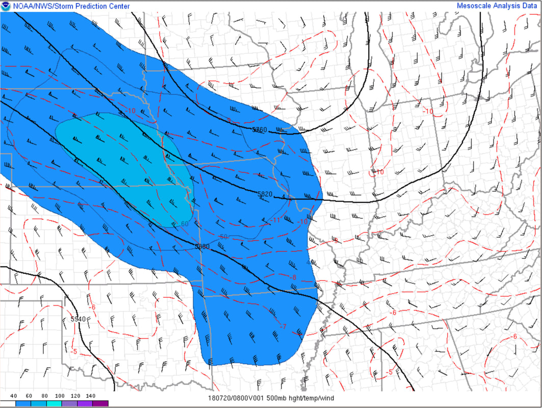
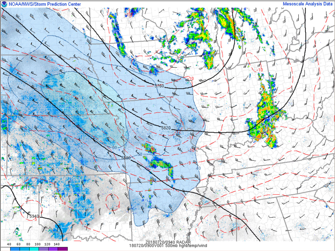
In this image, you see the 500 mb winds (this is roughly 18,000 feet up) and the 60-80 knot jet streak that is going to cause havoc today. These winds are wrapping around an upper level low to the north. The 2nd image has the radar data superimposed on it.
Saturday Saturday Saturday At least for our area, the NWS says it's a challenging forecast... "Challenging forecast for Saturday as well as we will be on the back side of the shortwave but instability will be maximized by afternoon with 3000 J/KG. In addition, mid levels will be cooling down quite a bit with -10C returning to NE GA at 500 mb adding fuel for storms. Because of these factors, have gone above the guidance for pops Saturday afternoon which are likely suffering from being watered down from the differing model solutions as far as timing is concerned Saturday." Depending on how today goes, it would not be too surprising to see an area of "Enhanced" risk for portions of Georgia for the Day One Severe Weather Outlook tomorrow.  SPC Day Two Severe Weather Outlook SPC Day Two Severe Weather Outlook The Storm Prediction Center also highlights the challenge of the Saturday forecast. ...Southeast... "Considerable uncertainty lingers, particularly concerning sub-synoptic details which could impact convective potential for Saturday. There is a signal within at least some model output that remnant convection and/or convective outflow from Friday night may be in the process of spreading across parts of the central/eastern Gulf states at 12Z Saturday. It is possible that this activity could re-intensify and pose a severe wind risk as it advances toward Alabama/Florida Panhandle coastal areas, where CAPE may become moderate to large by midday. If this initial development does indeed occur, it remains unclear how this may impact the environment to the north. However, guidance is generally suggestive that the lingering moisture, daytime surface heating, and weak to modest mid-level cooling probably will contribute to moderately large CAPE across at least parts of the Tennessee Valley, southern Appalachians and adjacent Piedmont by late afternoon, if not before. It appears that this may be favorably timed with forcing for ascent accompanying a 30-50 kt mid-level jet streak, which would provide sufficient vertical shear for organizing storm clusters. Isolated supercell structures might be possible initially, perhaps accompanied by a risk for hail and a tornado or two, but the risk for potentially damaging wind gusts appears the primary potential hazard at the present time." I'll be keeping an eye on things for you, so please keep checking back for frequent updates. |
Archives
March 2019
Categories
All
|
OLD NORTH GA WX BLOG


 RSS Feed
|
Never base important decisions on this or any weather information obtained from the Internet. Always have a backup method of receiving weather information such as a battery powered weather radio.
Copyright © 2018 NorthGeorgiaWX.com and DaculaWeather.com 
|