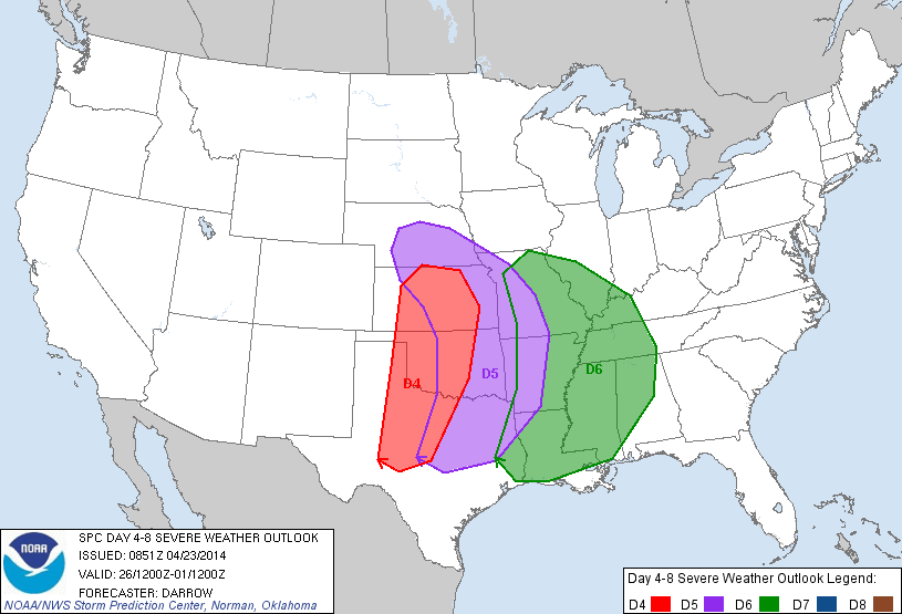
 The likelihood of severe weather has been on the increase for this weekend and early next week, and it's something we are going to start watching and getting you prepared for. The Storm Prediction Center has started issuing some strongly worded discussions about the severe weather potential for this weekend into early next week, and especially this far in advance. It appears that much of the really severe weather may stay a little further west and north of our area, but there is still plenty of time for things to change. From this mornings 4-8 day forecast discussion from the SPC: DAY 4-8 CONVECTIVE OUTLOOK Quite a few experienced meteorologists are expressing their concern about the severe potential, this Tweet is from Reed Timmer, probably the most well known storm chaser in the United States. 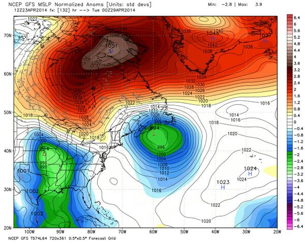 NAO Block in Orange NAO Block in Orange It appears that beginning Sunday, the pattern across the entire country will be changing, placing us in the cool wet area that may last for a little while. Things are looking very similar to the way it did this winter with a ridge over Alaska, but one big change. We are getting ready to experience what we wished we had, but never really saw over the winter... a negative NAO. The NAO is the North Atlantic Oscillation, a large scale atmospheric blocking regime that occurs when a ridge of high pressure sets up near Greenland. In the winter time, this block helps to keep the cold air bottled up over the continental US, versus pushing off to the Atlantic ocean. We really haven't had a significant NAO- since last October. Dr. Ryan Maue said this about his image from Weatherbell.com: "GFS 12z huge surface High over NE Canada in 5 days blocking everything. 1051 mb". What that means, is that whatever cold air pushes south, gets locked in place for a while. Welcome summer... 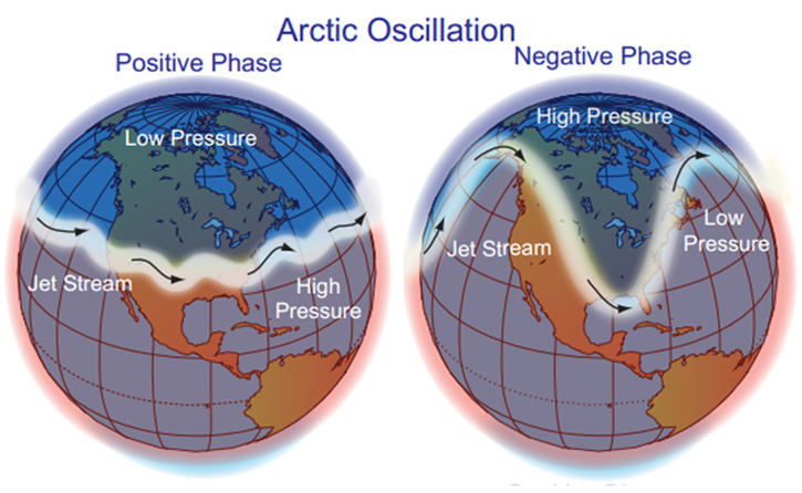 On top of that, the AO or Arctic Oscillation, is also going negative.... having both negative at the same time is a double bonus... and absolutely what we wanted over the winter. So we finally get double blocking and it's almost summer time. Go figure. Here's an image of the AO and how the different phases imply different weather conditions for us here in the southeast. Again, this double block means a slow to leave, wet, and cool period across the southeast for while. When the AO index is negative, there tends to be high pressure in the polar region, weaker zonal winds, and greater movement of frigid polar air into middle latitudes. In the positive phase, higher pressure at mid-latitudes drives ocean storms farther north, and changes in the circulation pattern bring wetter weather to Alaska, Scotland and Scandinavia, as well as drier conditions to the western United States and the Mediterranean. 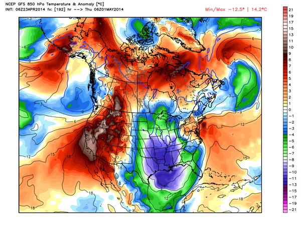 After the severe weather on Monday/Tuesday, temperatures will drop behind the front with very cool temps for this time of year, with the start of May much like last year with very cool anomalies. You'll notice from looking at this map, that high pressure keeps the cooler air bottled up to the south and east parts of the county. 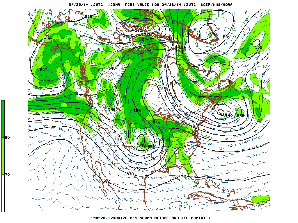 Upper level low over Kansas on Monday 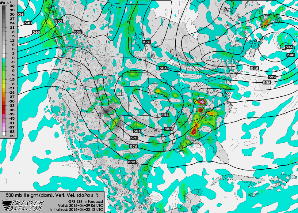 This is map of the vertical velocities on Tuesday. This gives you an idea of the lift in the atmosphere, and as you can see, there is fairly significant lift in association with the upper low. It appears that other severe weather parameters also indicate a severe weather event for us here.
Please stay tuned for more updates on this upcoming event, and make sure that you and your family has a severe weather plan in place BEFORE severe weather strikes. |
Archives
March 2019
Categories
All
|
OLD NORTH GA WX BLOG
 RSS Feed
|
Never base important decisions on this or any weather information obtained from the Internet. Always have a backup method of receiving weather information such as a battery powered weather radio.
Copyright © 2018 NorthGeorgiaWX.com and DaculaWeather.com 
|