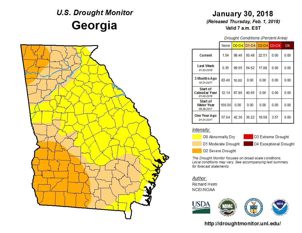
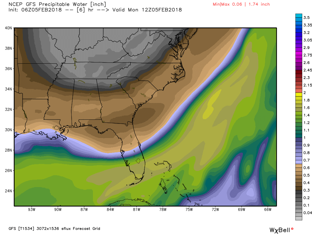
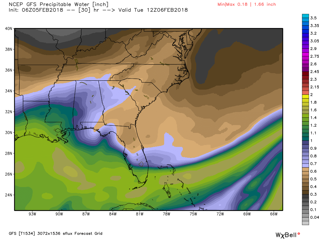
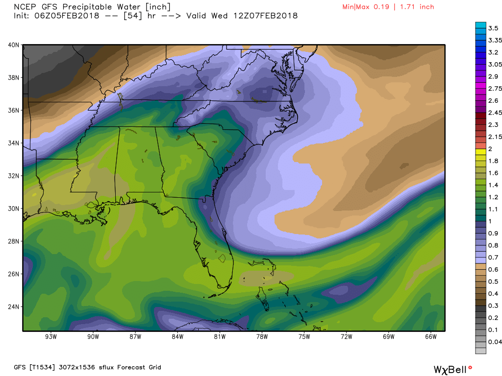
 Most recent drought map (Updates Thursday) Most recent drought map (Updates Thursday) One benefit of the warmer temperatures has been the rainfall we've seen over the last week, and it appears that the drought busting rain will continue through the rest of this week. The latest drought map (to the left, click to enlarge) was issued last Thursday and doesn't account for the rainfall we've had since the 28th of January. While we will dry out a little today, the moisture will be on the increase beginning tomorrow and we will be back into the soupy atmosphere for Wednesday. According to the NWS, Wednesday will end up being like last Saturday in terms of being a washout and there will even be a chance for a few thundershowers, but nothing severe. The three images below show the precipitable water values for Mon-Wed. The brown and grey colors show very dry air, while the greens are very moist. You can see how our low and mid level flow starts to bring a return flow from the Gulf on Tuesday (center image) and a deeper surge for Wednesday.
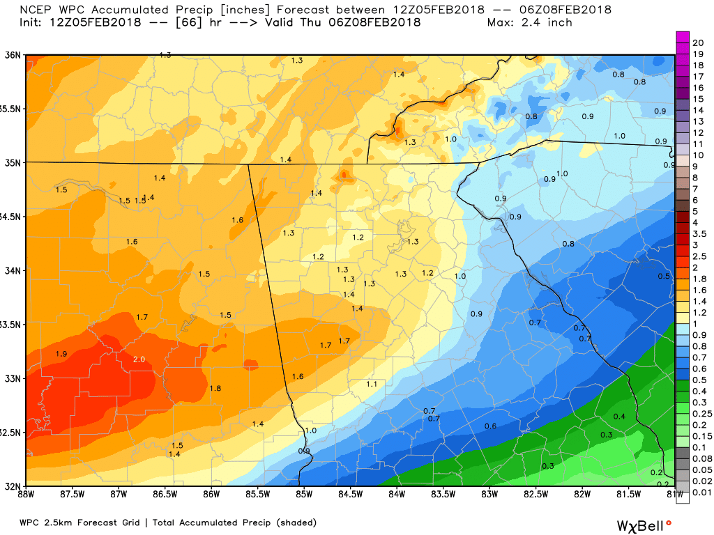
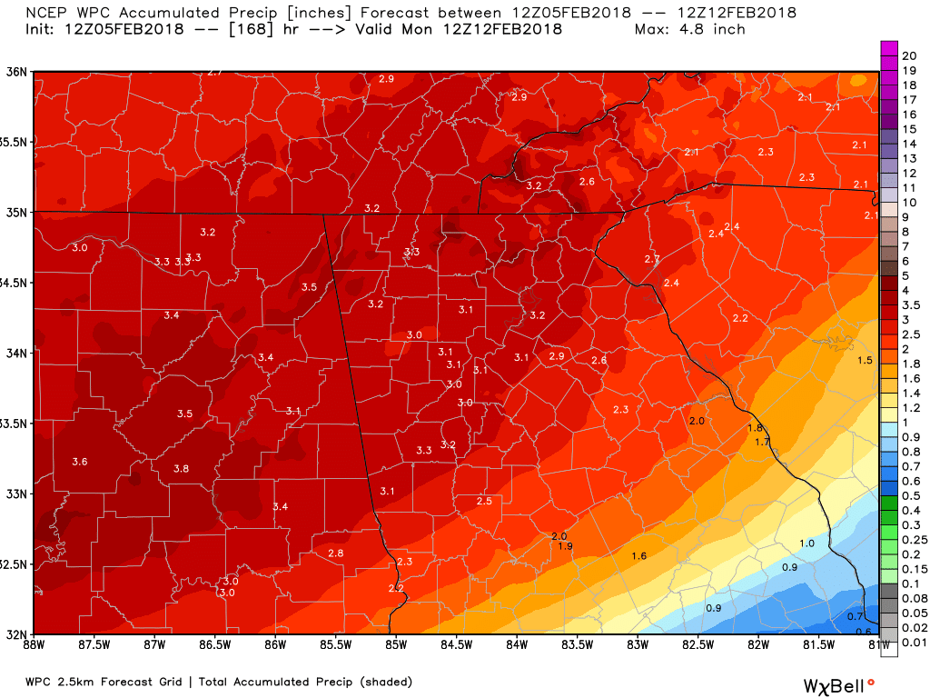
Round #1 rainfall totals are forecast to look like the left image, and then add the rainfall from system #2 from next weekend, and you get a grand total that looks like the image on the right.
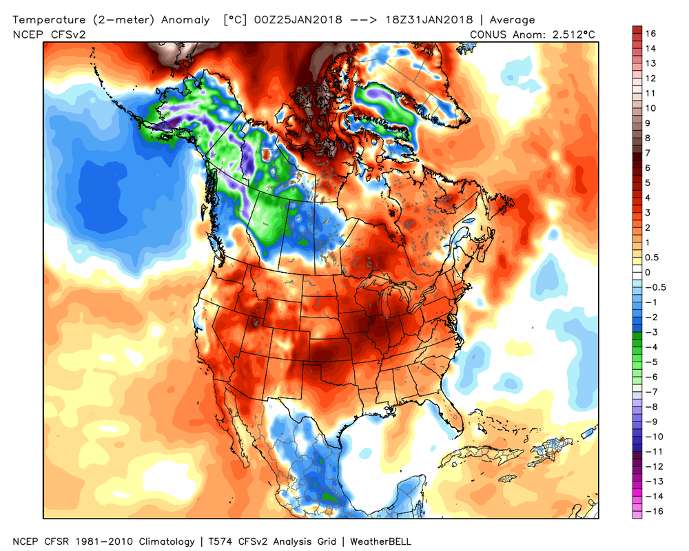
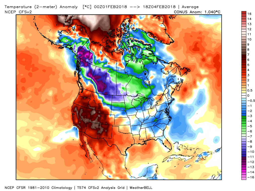
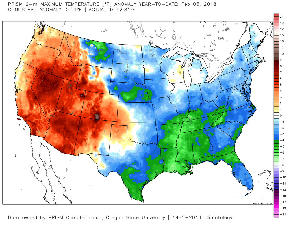
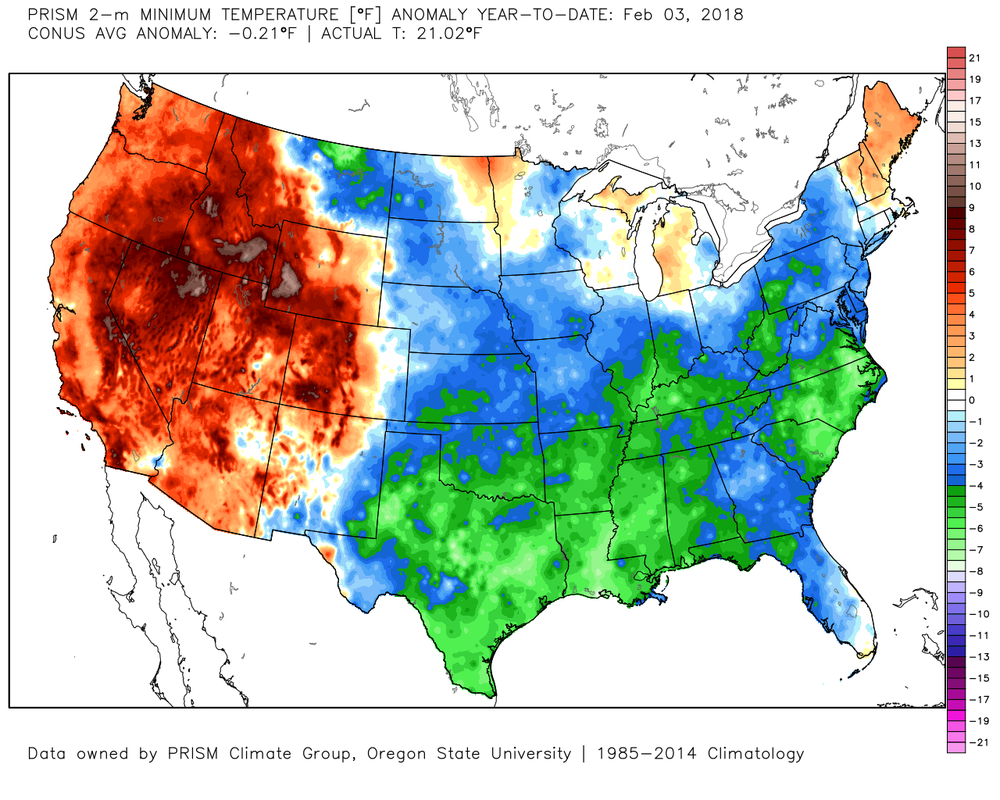
Here is the rainfall reanalysis map at a look back at the last 7 days that shows our total rainfall from 7 am Sunday, January 28th through 7 am Sunday, February 4th. 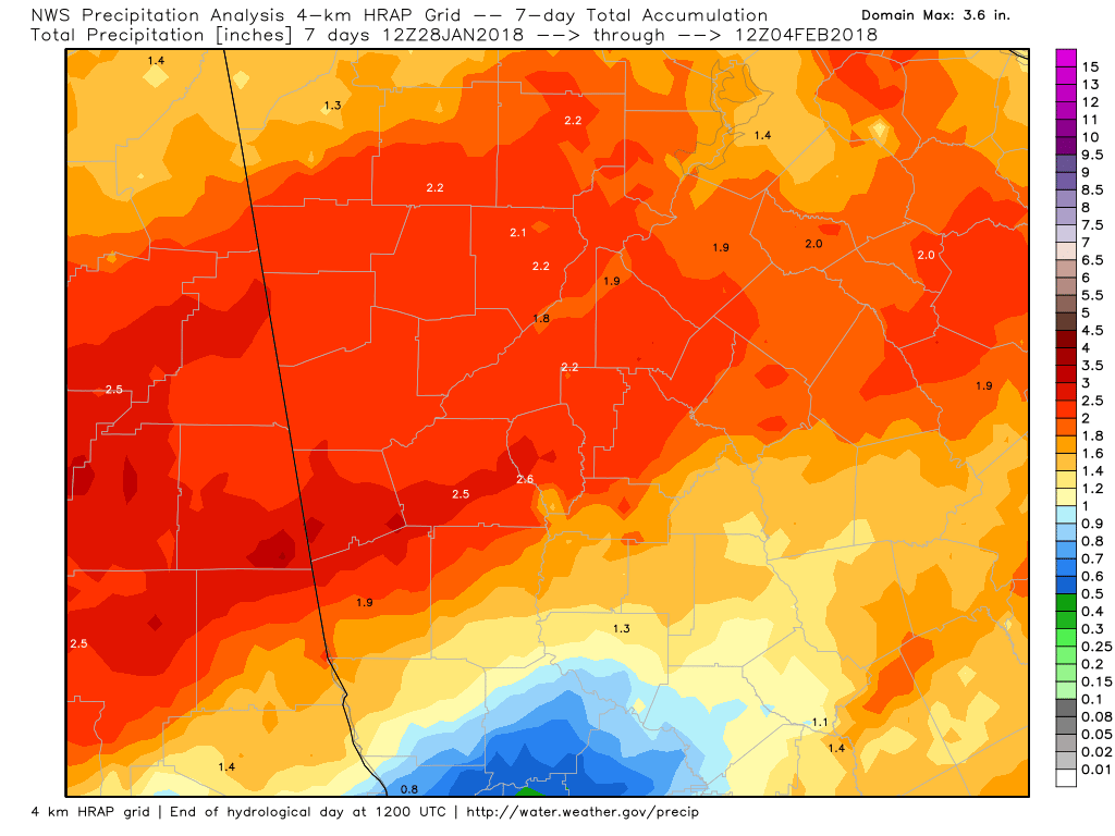 As if you didn't already know, temperatures over the last 7 days have been above normal (left image) and we expected this, so no surprises here. The image to the right is for this month so far, and you can see we've been slightly below normal. Temperatures will be running some 10-15 degrees above normal this week, so enjoy the comfortable temperatures while you can. Winter is not over by a long shot.
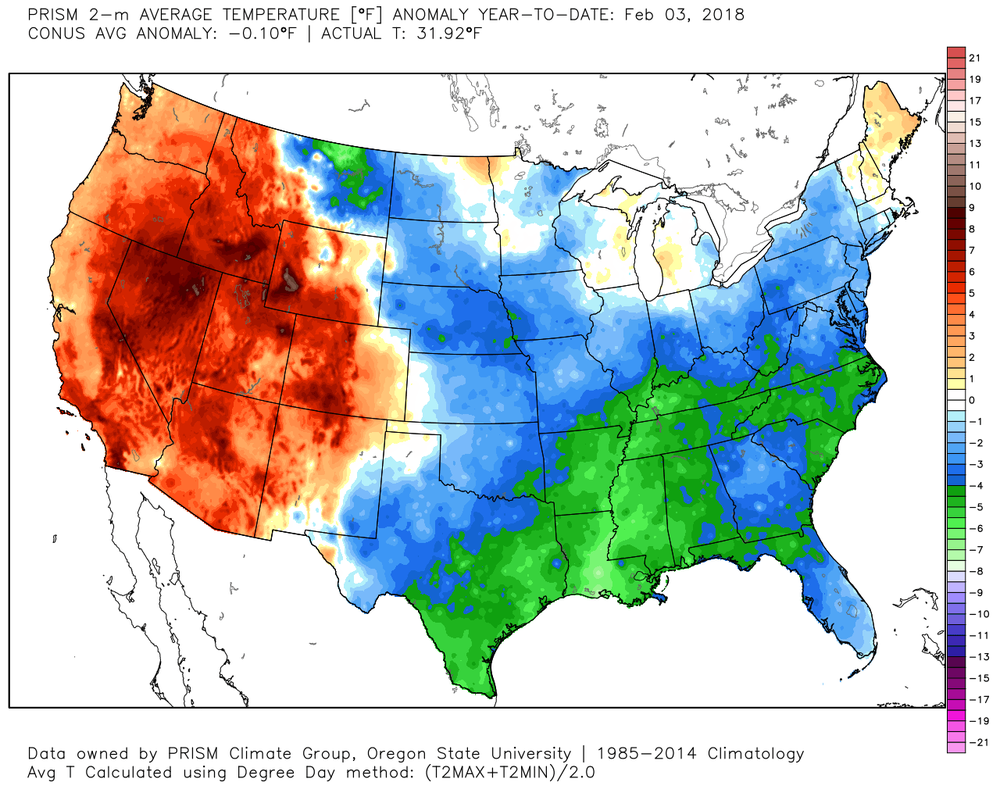
Here's a look at our temperatures (not anomalies) since January 1 from the Prism 4km Reanalysis.
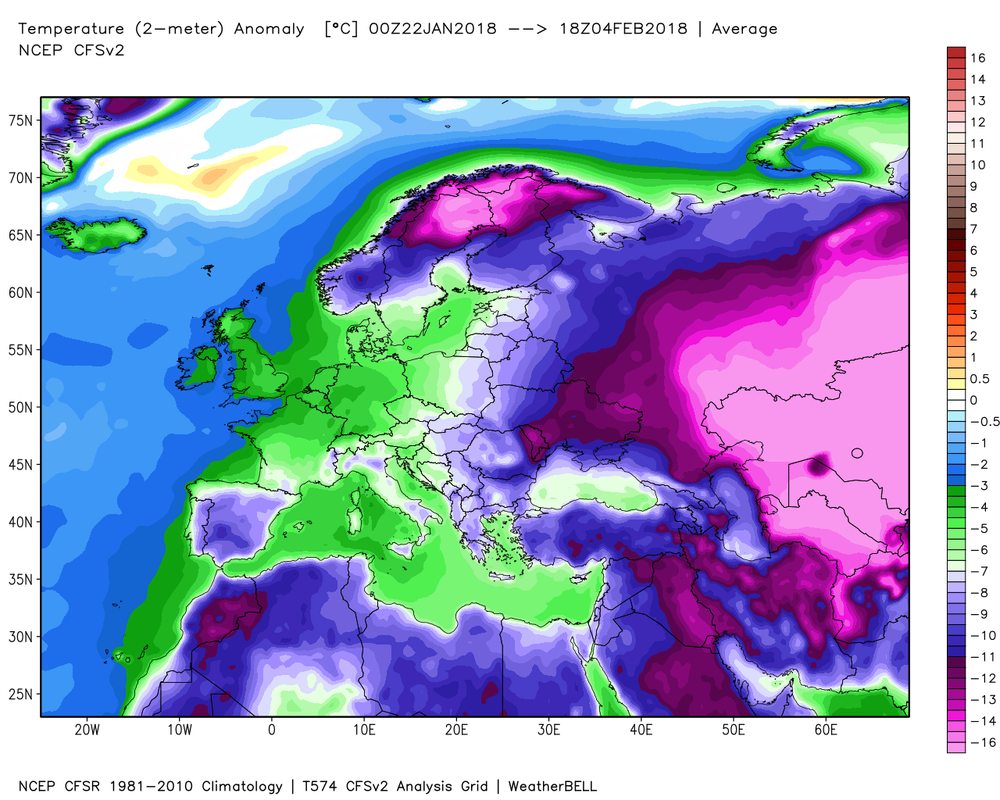
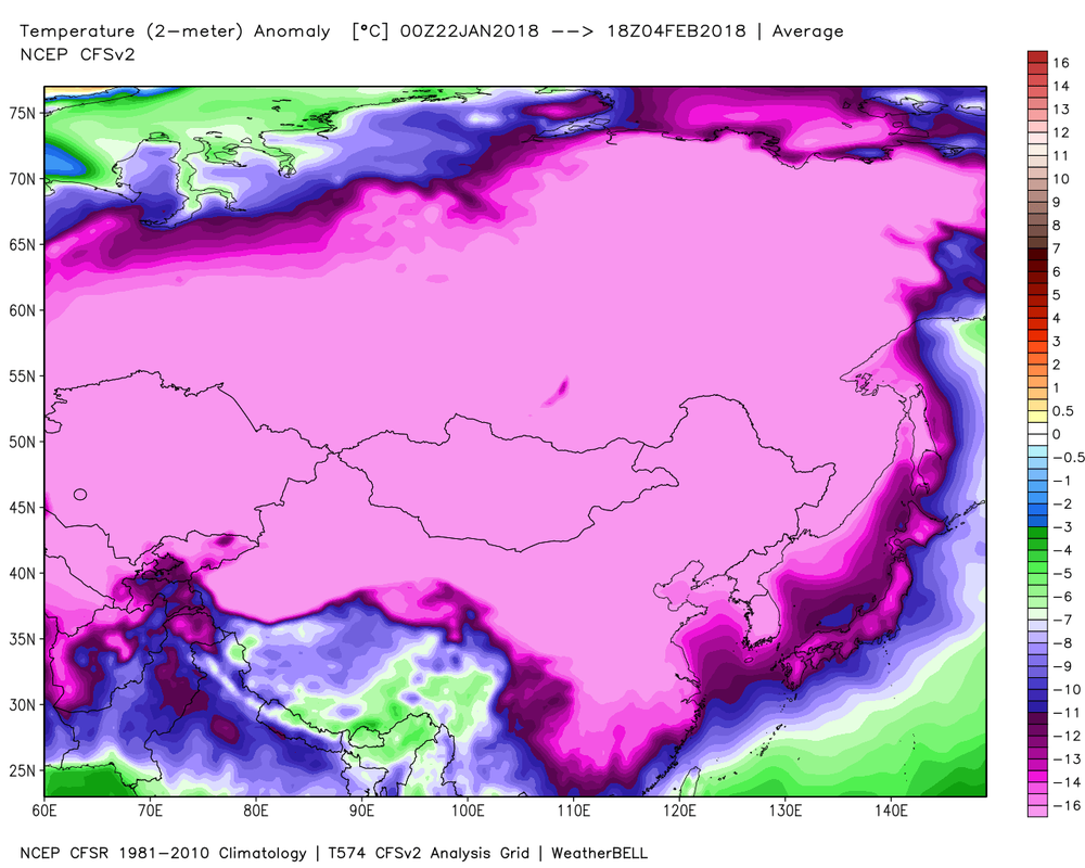
Want to see where the coldest temperature anomalies have been while we basked in mid-winter warmth? Here's a look at the past 14 day anomalies in Europe and Asia.
Here's a look at the coldest places in the Northern Hemisphere ending at 7 am this morning (Feb 5th). You can find the weather extreme's page here: www.daculaweather.com/4_world_extremes.php The page defaults to the U.S. but you can choose other regions of the world. Be patient... it takes 10 seconds or so for the script to retrieve the data. 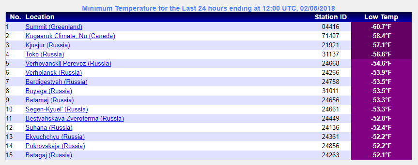
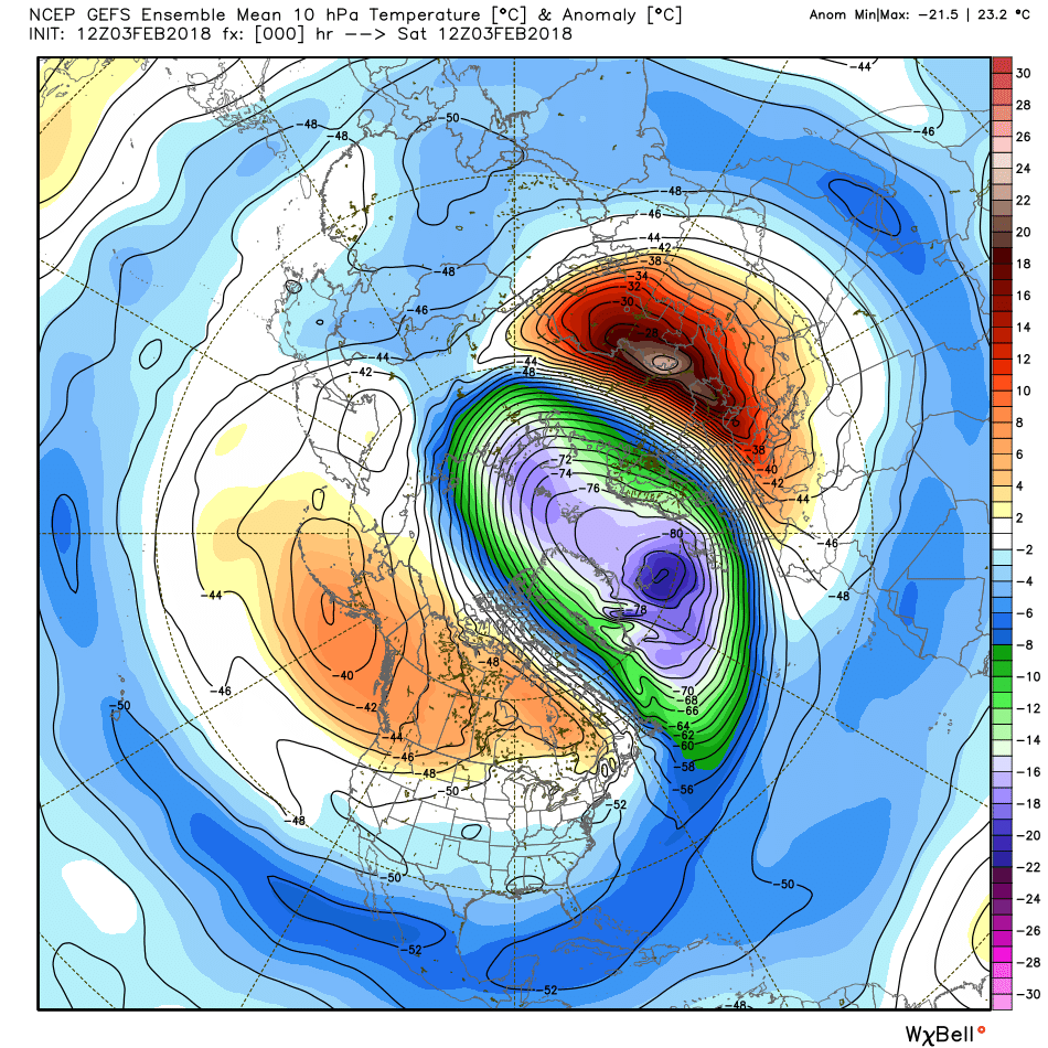
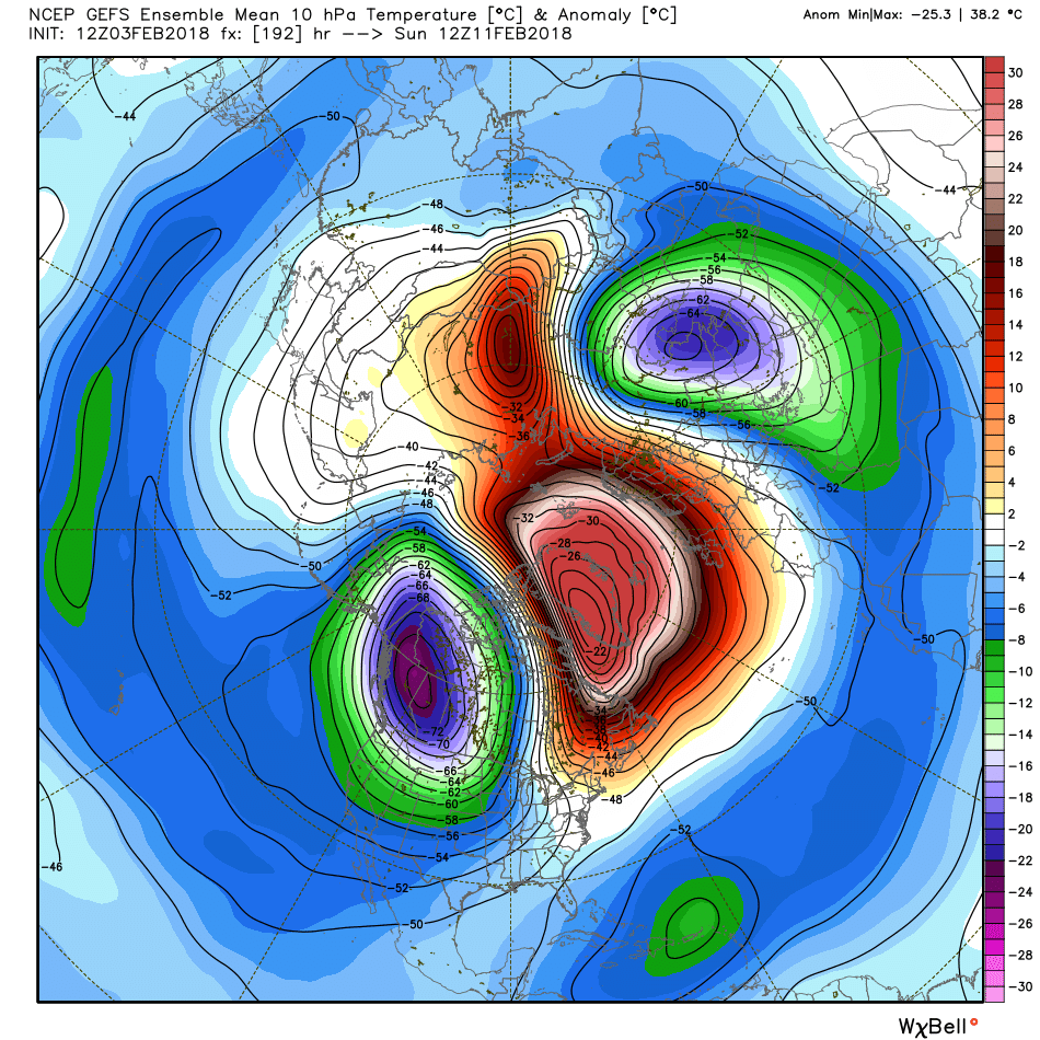
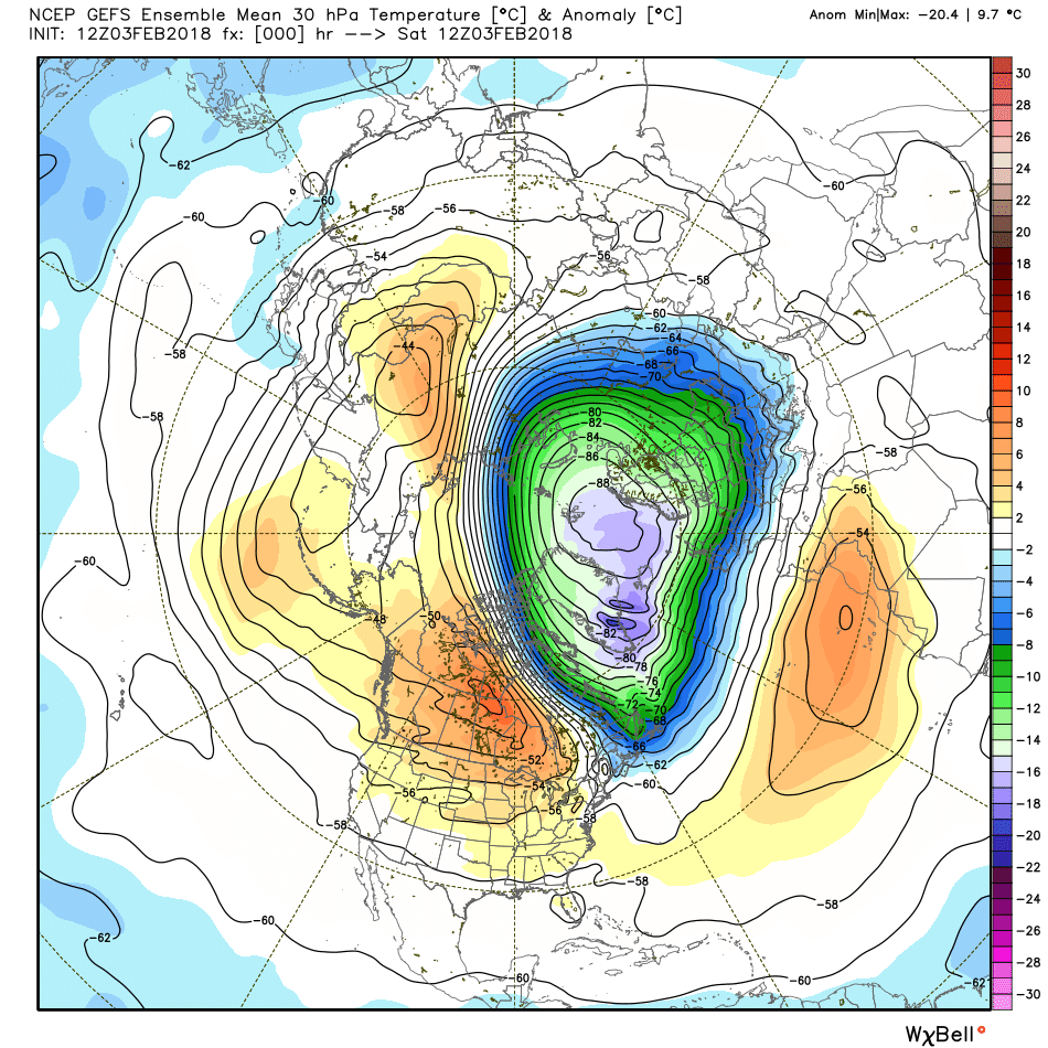
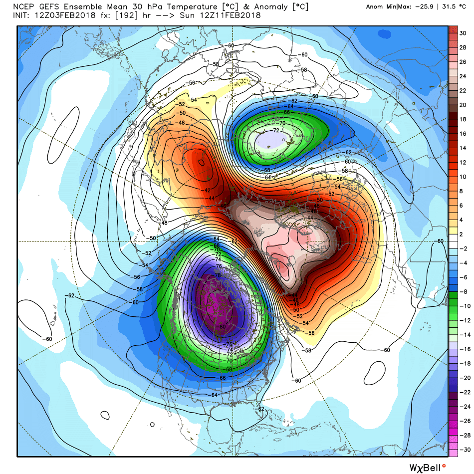
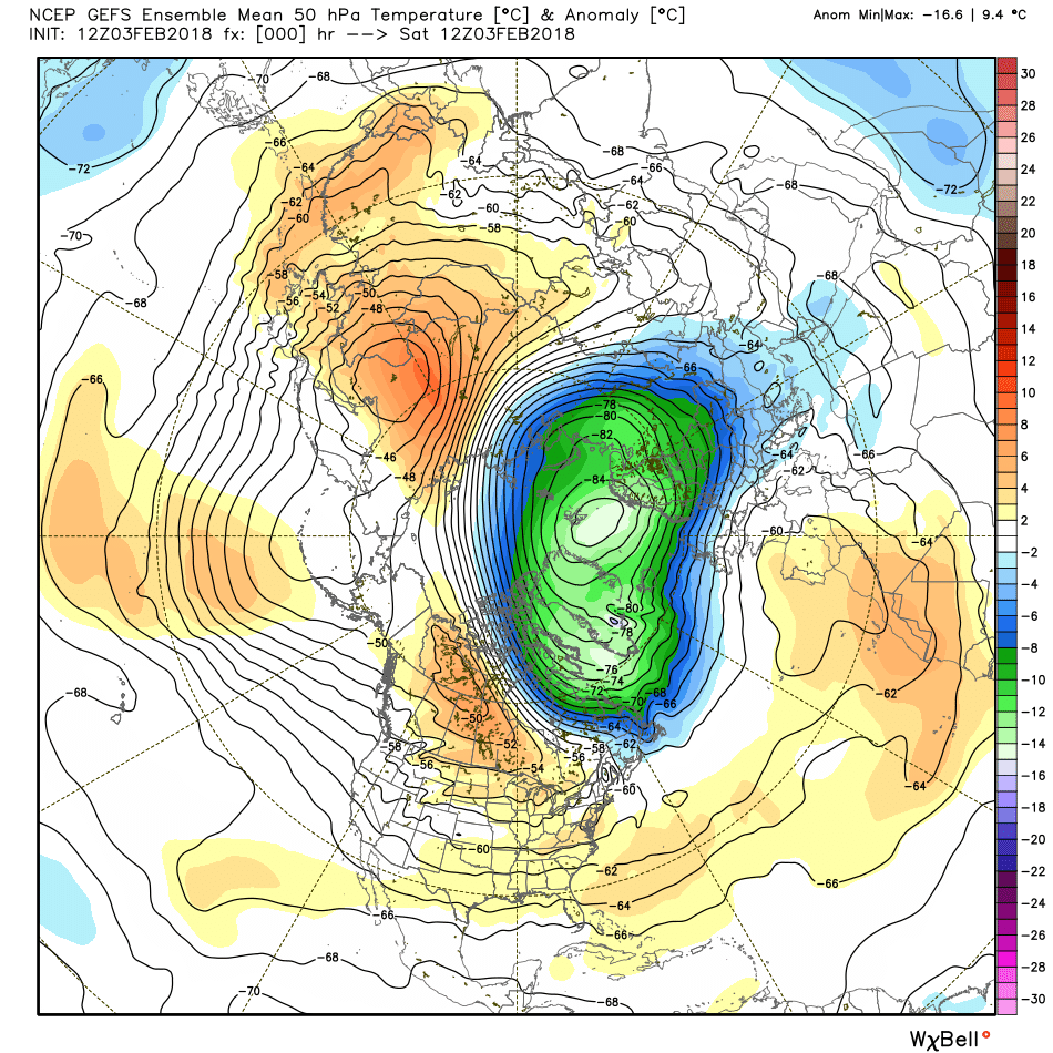
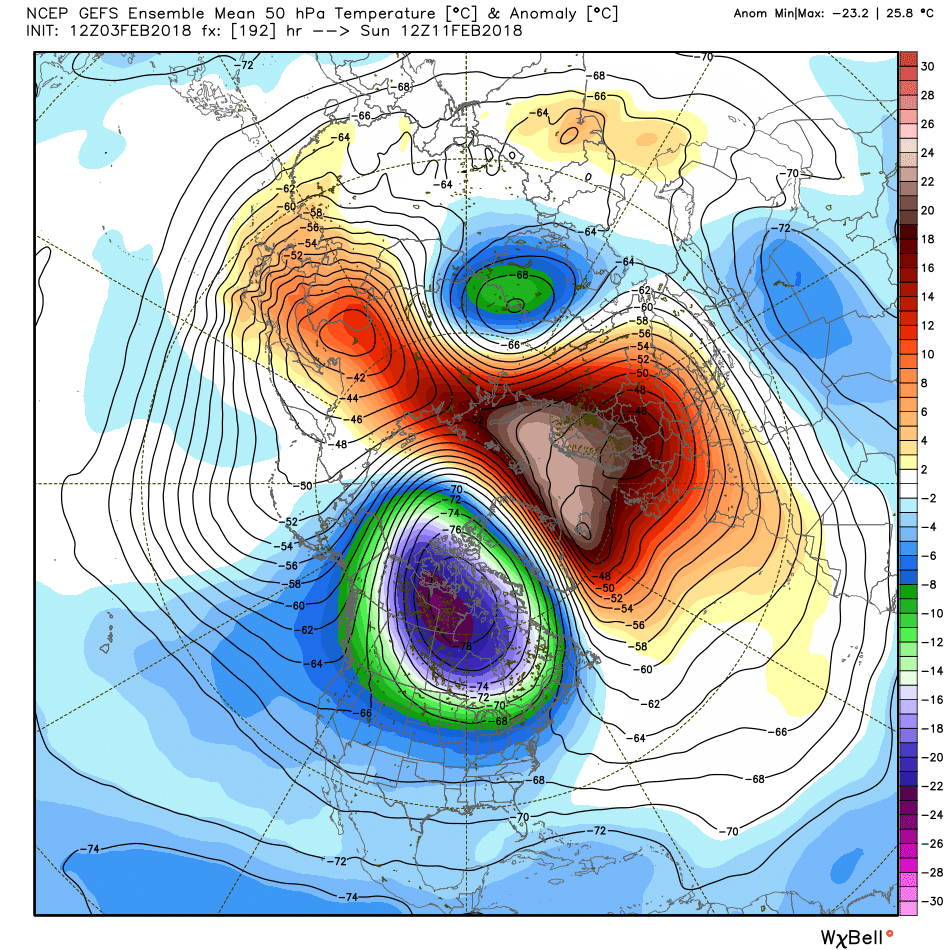
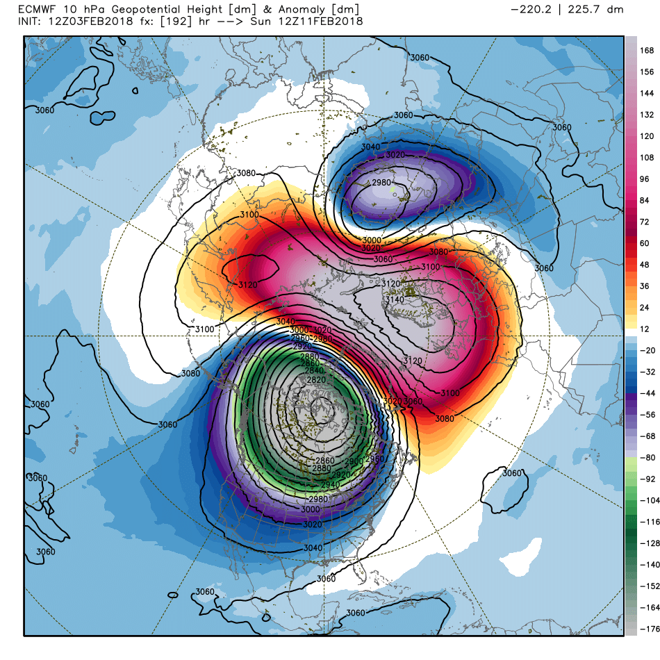
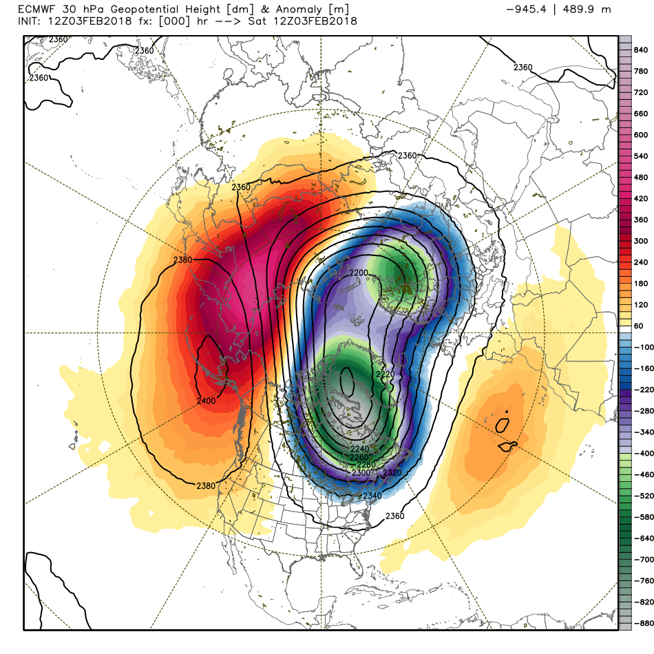
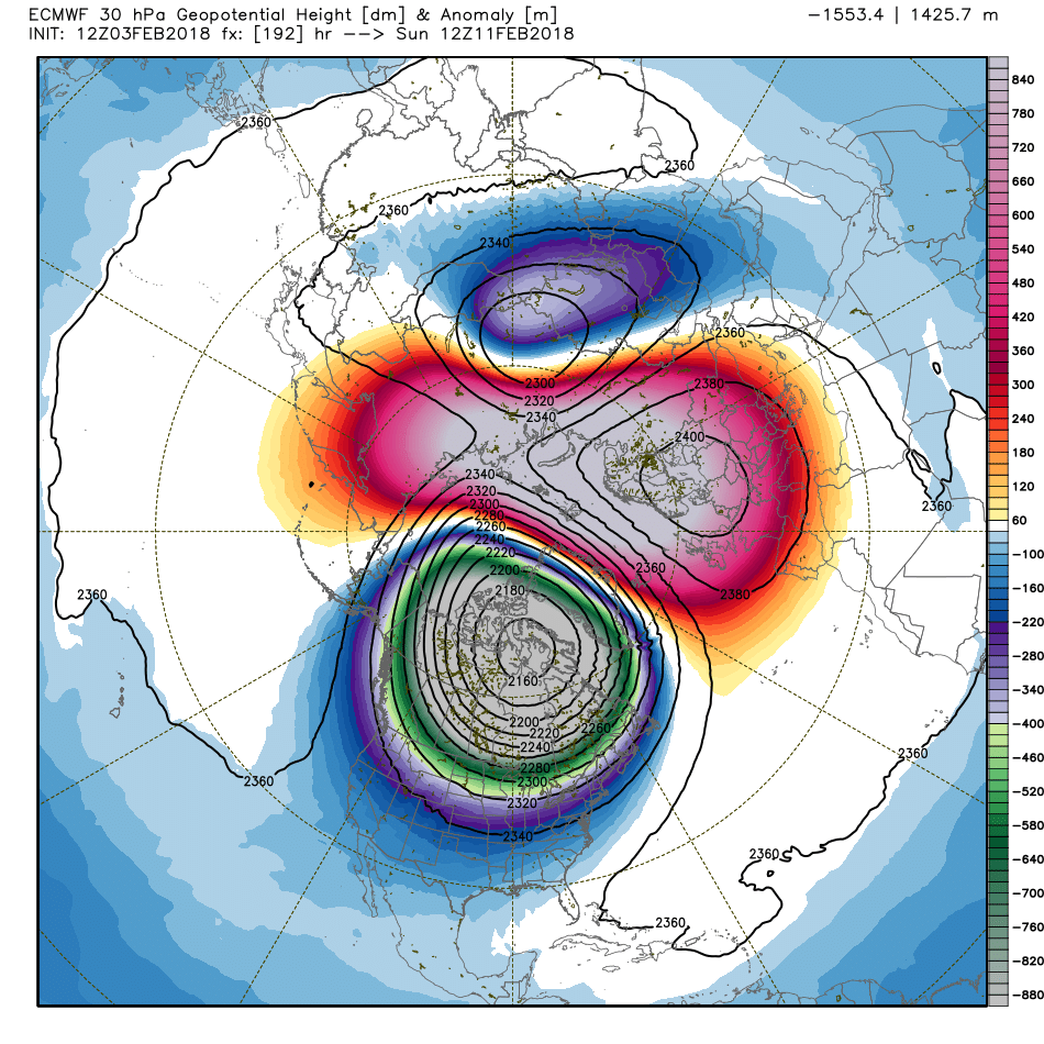
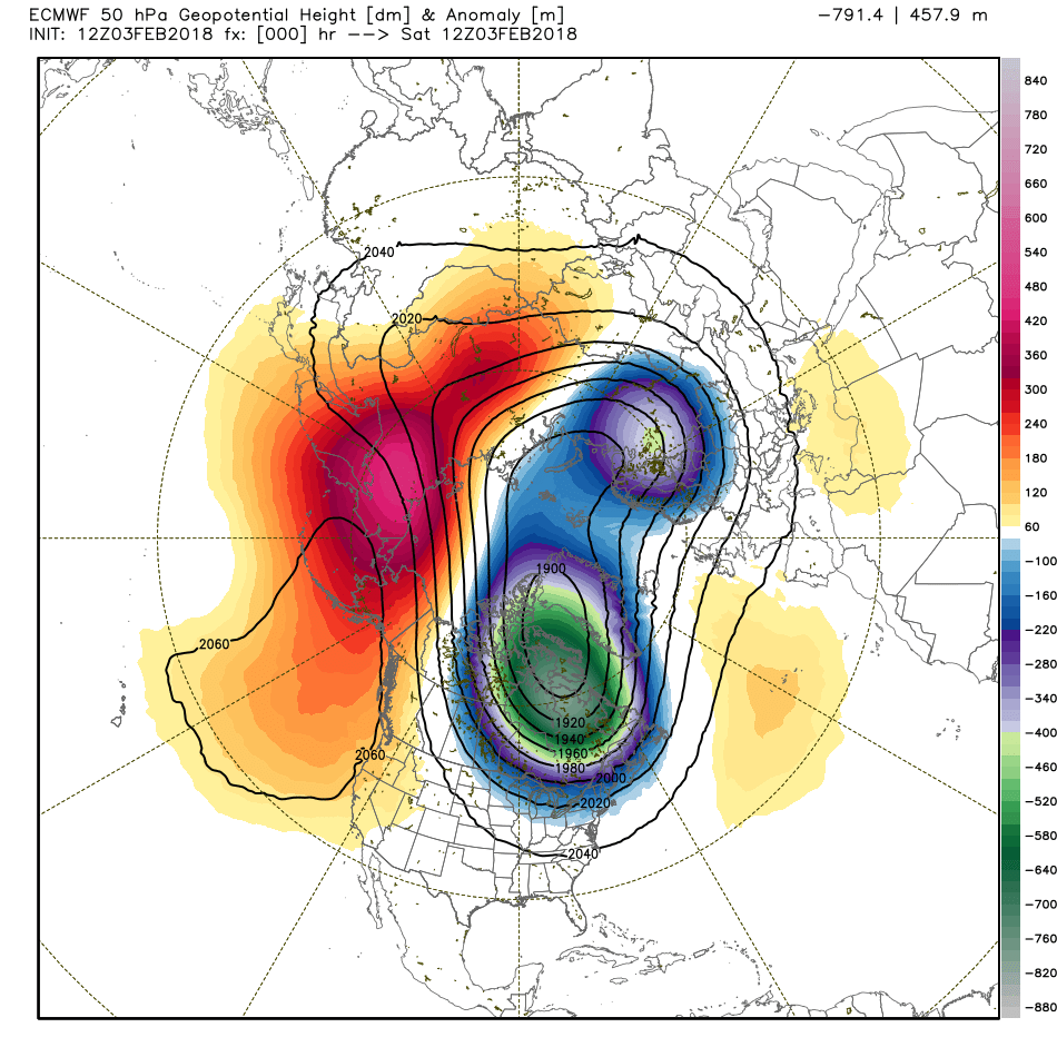
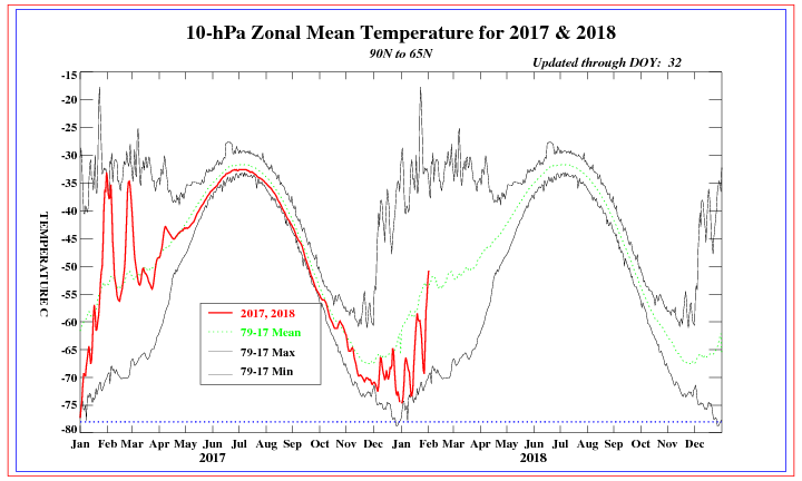
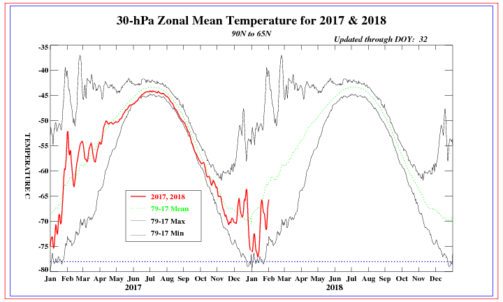
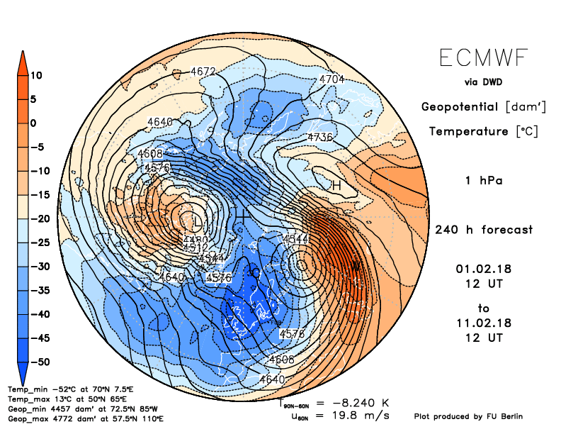
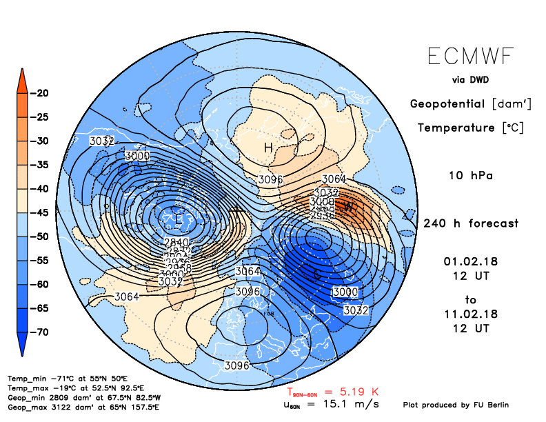
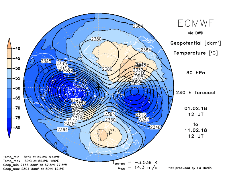
Here's a look at the current and the 8 day stratosphere forecast by both major models. These are at 10 hPa, 30 hPa, and 50 hPa levels. It's looking pretty certain we will see this split, and if so, it may make for a very lively end to the winter season. The last event we had was in January 2013 and before that, February and March of 2010.
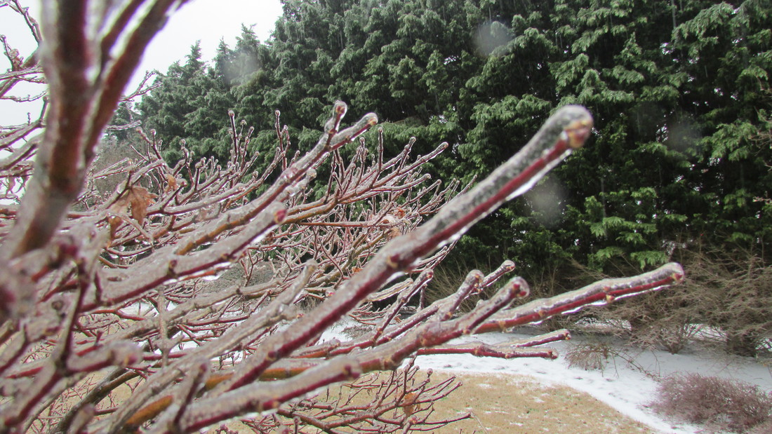 Ice in my backyard in January 2014 Ice in my backyard in January 2014 Looks like we have a chance for some winter weather tonight across the northern tier of counties in the mountains, and especially toward the NE corner of the state, where many will possibly see some significant icing. Fortunately, temps will rise above freezing Sunday, so it will be a short lived event. First, let's look at the Winter Weather Advisory. By definition, a Winter Weather Advisory is "issued up to 36 hours before an event for an 80% or greater chance of a winter precipitation event "snow, freezing rain/drizzle, sleet or blowing snow) which causes inconveniences but does not meet warning criteria." Here is the advisory: WSWFFC URGENT - WINTER WEATHER MESSAGE National Weather Service Peachtree City GA 334 AM EST Sat Feb 3 2018 ...Winter Weather Expected for portions of Northeast Georgia Tonight and Sunday Morning... .An arctic airmass currently in place will begin to be overrun by mid and upper level moisture during the evening Saturday and the overnight hours Sunday morning. As a result mixed precipitation is expected to occur across portions of North and Northeast Georgia. Some sleet will be possible at the onset of precipitation for areas outside the advisory area including the Atlanta Metro however no impacts are expected. As precipitation increases in intensity after midnight... it is expected to transition over to all freezing rain within the advisory area and accumulate. Temperatures are expected to remain at or below freezing through the late morning hours Sunday before warming above freezing in the advisory area. Fannin-Gilmer-Union-Towns-Pickens-Dawson-Lumpkin-White-Hall-Banks- Including the cities of Dahlonega, Cleveland, and Gainesville 334 AM EST Sat Feb 3 2018 ...WINTER WEATHER ADVISORY IN EFFECT FROM 1 AM TO 10 AM EST SUNDAY... * WHAT... Mixed precipitation expected. Total snow accumulations of up to one half inch and ice accumulations of around one tenth are expected within the advisory area. * WHERE... Portions of north central and northeast Georgia. * WHEN... From 1 AM to 10 AM EST Sunday. * ADDITIONAL DETAILS... The ice will result in difficult travel conditions... especially on bridges and overpasses. Be prepared for reduced visibilities at times. PRECAUTIONARY/PREPAREDNESS ACTIONS... A Winter Weather Advisory means that periods of snow, sleet or freezing rain will cause travel difficulties. Be prepared for slippery roads and limited visibilities, and use caution while driving. Also for Georgia and issued by the Greenville/Spartanburg NWS office: -------------------------------------- Rabun-Habersham-Stephens-Cleveland-Greater Caldwell-Greater Burke- Eastern McDowell-Greater Rutherford-Eastern Polk-Oconee Mountains- Pickens Mountains-Greenville Mountains-Greater Oconee- Greater Pickens-Greater Greenville-Spartanburg-Cherokee-Anderson- Including the cities of Clayton, Pine Mountain, Mountain City, Cornelia, Demorest, Clarkesville, Hollywood, Boydville, Toccoa, Shelby, Kings Mountain, Kings Creek, Lenoir, Sawmills, Granite Falls, Morganton, Pleasant Grove, Valdese, Marion, Nebo, Dysartsville, Fero, Glenwood, Forest City, Rutherfordton, Spindale, Tryon, Columbus, Mill Spring, Mountain Rest, Walhalla, Westminster, Pumpkintown, Tigerville, Gowensville, Cleveland, Seneca, Oakway, Easley, Dacusville, Clemson, Greenville, Taylors, Greer, Mauldin, Fork Shoals, Simpsonville, Berea, Spartanburg, Gaffney, and Anderson 328 AM EST Sat Feb 3 2018 ...WINTER WEATHER ADVISORY IN EFFECT FROM 1 AM TO 10 AM EST SUNDAY... * WHAT...Mixed precipitation expected. Total snow accumulations of up to one inch and ice accumulations of around one tenth are expected. * WHERE...Portions of upstate South Carolina, northeast Georgia, and the northwest piedmont and foothills of western North Carolina. * WHEN...From 1 AM to 10 AM EST Sunday. * ADDITIONAL DETAILS...The ice will result in difficult travel conditions. Be prepared for reduced visibilities at times. PRECAUTIONARY/PREPAREDNESS ACTIONS... 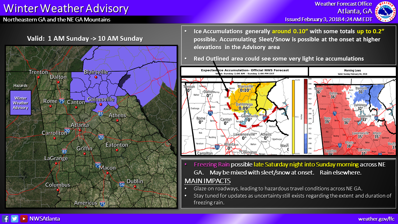 Cold air moving in today will set NE GA up for some potential ice early Sunday. Areas north of I20 could see some sleet mixing in as the precip moves in late Saturday before changing to all rain. NE GA may see some accumulations of freezing rain on trees and bridges/overpasses by dawn Sunday. Impacts would be mostly confined to travel with all of it gone by afternoon as temperatures warm above freezing.
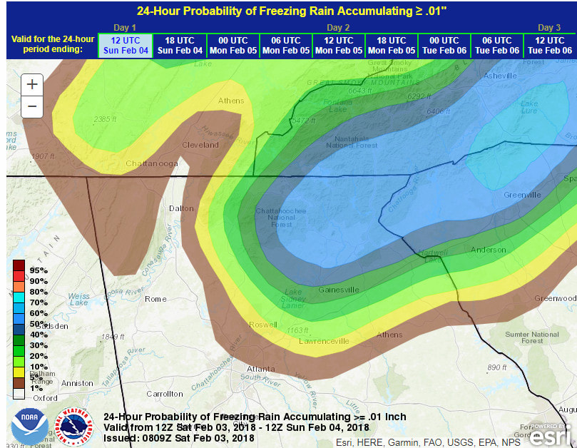
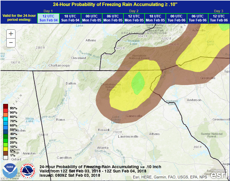
 It is always a good idea to read the AFD's or area forecast discussions to get a good feel for what the National Weather Service is thinking behind the forecast. Here is an excerpt from the latest AFD from 3:15am Saturday AM. ----------------------------------------- All eyes will be to the west this evening as modest but large area of energy moves out of the plains and into the Mississippi Valley. Quick movement of this system will allow for a rapid transition from mid level clouds to low clouds and developing precipitation by 03Z to 06Z. Almost invariably in these type of setups, we get more sleet than we think at the onset and expect to hear of reports even in the metro, although no travel issues are anticipated with temps above freezing. A different story for NE GA where insitu wedge situation looks to develop. Have gone with a blend of the coldest guidance including the regional Canadian to yield onset temps in the upper 20s to around 30. Top down method gives me everything including the kitchen sink for precip type... rain... freezing rain.... sleet... and even a little snow at the highest elevations. Transitions to all FZRA and RA though and expect those to be the primary hazards with this event. Even a glaze of ice satisfies advisory for the local area and with a possible tenth of an inch, will hoist one for portions of NE GA from 06Z-15Z. Will be a very slow warmup and will stick close to cold guidance again with only mid 30s for highs within the wedge Sunday. Otherwise, QPF looks manageable at under and inch for all locales. Here are two probability maps from the Weather Prediction Center (WPC) showing the probability of freezing rain >=0.01" (left) and >=0.10" (right)
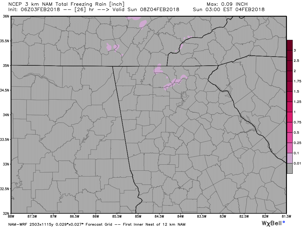
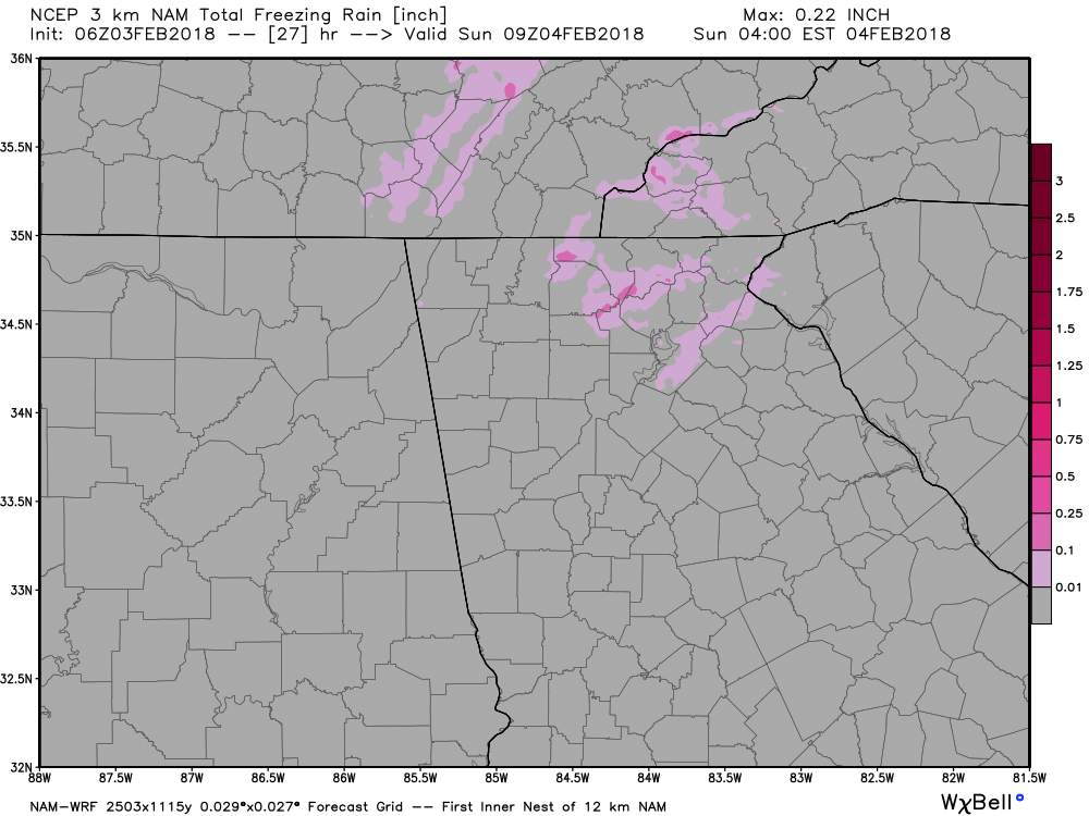
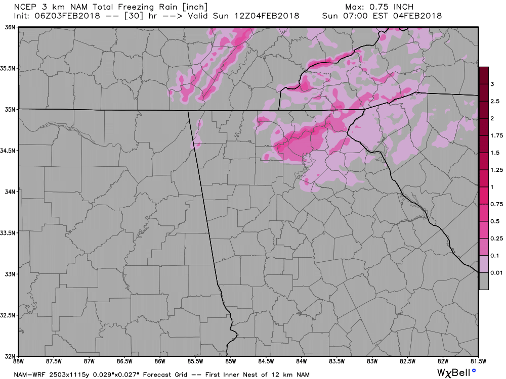
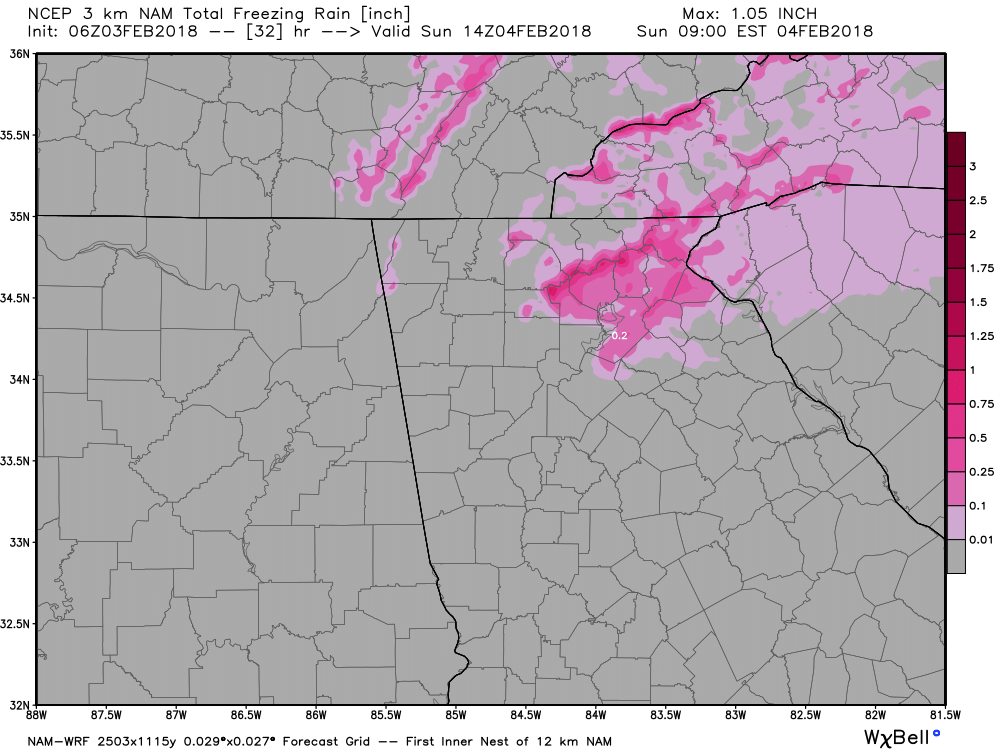
Here's a sequence of images from the NAM 3km showing how it sees things playing out. It's QPF amounts are on the high side but you can get a feel for how this model sees the placement. Click to enlarge the images.
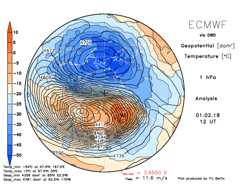
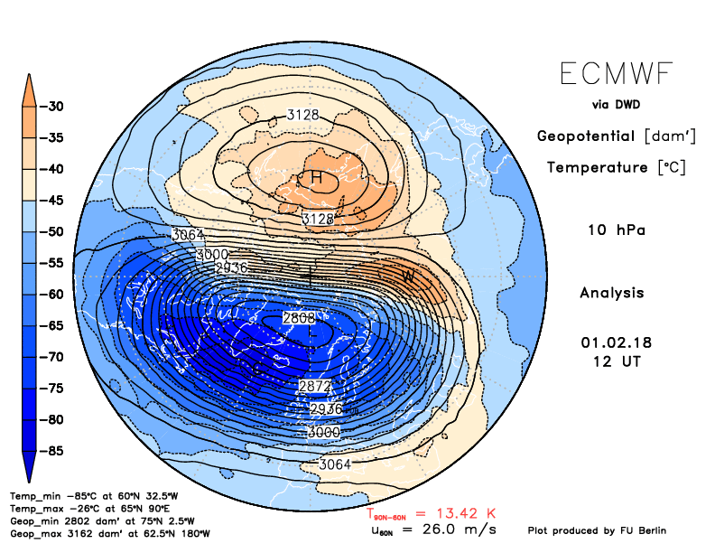
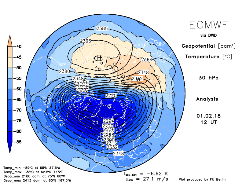
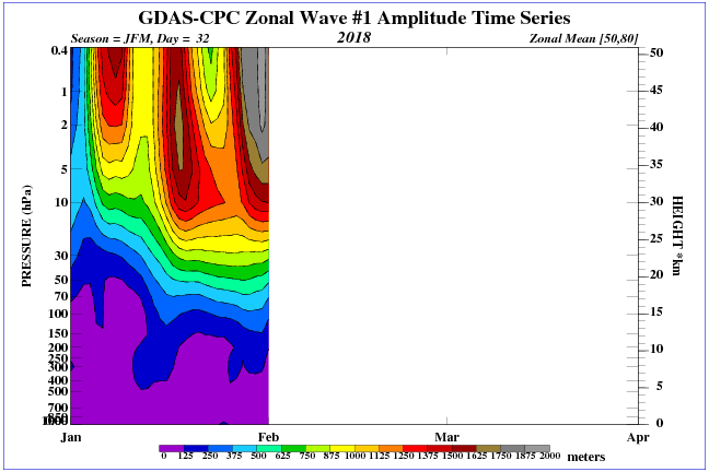 Wave 1 pressure changes Wave 1 pressure changes The winds of change are blowing... the upper levels of the stratosphere are beginning to quickly warm and winds toward the upper levels have started a reverse. Let's look at a few images. First, we'll look at the temperatures beginning at 1mb down to 30mb. Right now the warming is starting at the top as you see in the first few images. 1mb is to the left and 30mb is to the right. Also, notice that the warming hasn't reached or effected the 30mb region just yet, but it looks like it might be getting started. Click on any image to enlarge.
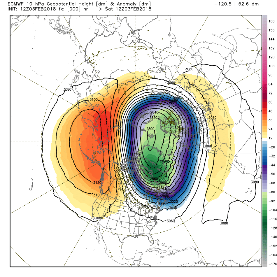
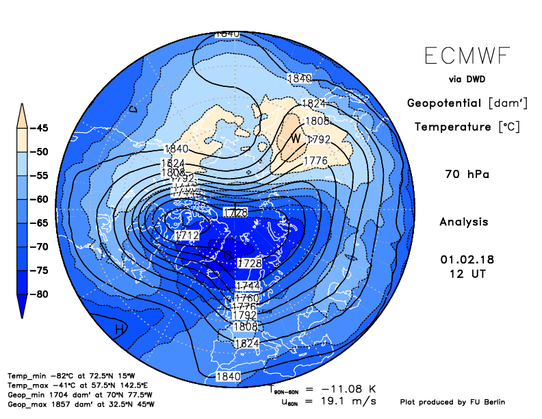
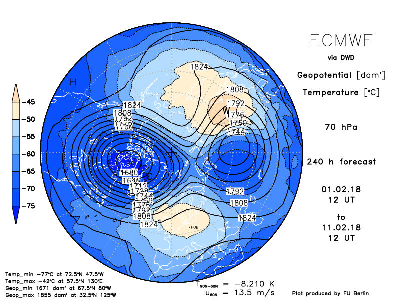
Once the upper levels warm, the westerly winds begin to slow and we are beginning to see that in this next image. That little sliver of green shows -20 to -30 meters/second which indicates an easterly component instead of the normal westerlies. Also note that during an east based QBO, winds will also reverse which helps to explain why during east based QBO's, we generally have better high latitude blocking. 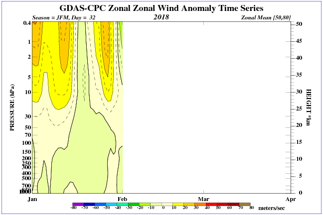 This image shows the warming (yellow and orange colors at the top right of the image) that is beginning to occur. 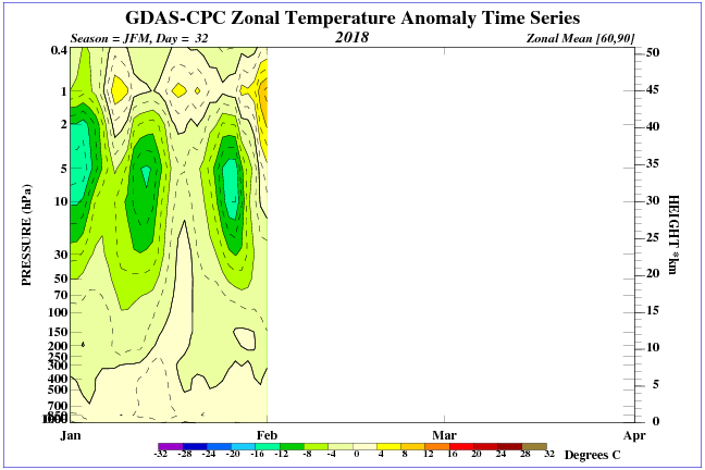 The Euro is seeing the splitting of the stratospheric polar vortex at 1mb, 10mb, 30mb and at 70mb. The current state is in the first column, the second column is 10 days. You can click on any image to enlarge it.
Almost all signs are pointing toward a disruption of the stratospheric polar vortex, and the implication is that this will also have a major influence on the tropospheric polar vortex. Depending on the strength of this event, the chances for high latitude blocking should be on the increase, which would generally mean colder arctic air getting pushed from the polar region southward. |
Archives
March 2019
Categories
All
|
OLD NORTH GA WX BLOG

 RSS Feed
|
Never base important decisions on this or any weather information obtained from the Internet. Always have a backup method of receiving weather information such as a battery powered weather radio.
Copyright © 2018 NorthGeorgiaWX.com and DaculaWeather.com 
|