 Additional drought maps can be found here:
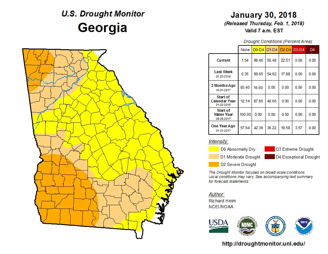
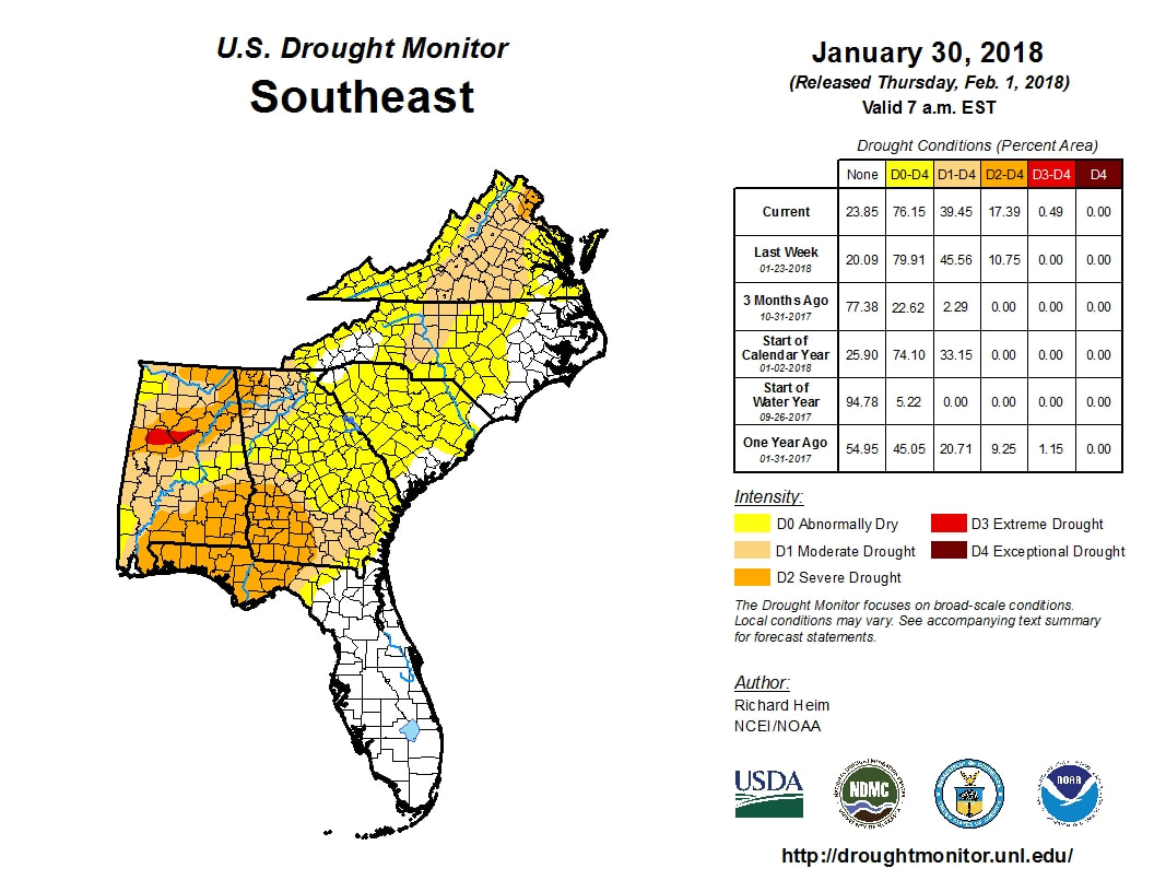
----------------------------------- Drought Information Statement for North and Central Georgia National Weather Service Peachtree City GA 1130 AM EDT Thu Feb 1 2018 ...SHORT-TERM SEVERE DROUGHT DEVELOPS OVER PORTIONS OF NORTHWEST AND WEST CENTRAL GEORGIA... ...ABNORMALLY DRY TO MODERATE DROUGHT CONDITIONS PERSIST ACROSS NORTH AND CENTRAL GEORGIA... SYNOPSIS... Over the last several weeks, rainfall deficits over north and central Georgia have continued to worsen, and drought conditions have expanded over the area. Since November, Georgia has been in a fairly active synoptic pattern, with weather systems traversing the area every 4 to 7 days. Regardless, measurable precipitation has been minimal, and at a times frozen precipitation has limited the opportunity for improvement to the dry soil conditions. As a result, Abnormally Dry conditions developed over portions of the state as early as late November, with Moderate Drought expanding over north and central Georgia through December. With persistent dry conditions, Severe Drought creeped into north and central Georgia in mid-January, and with increasing confidence that these dry conditions will continue or worsen, Drought Information Statements are being initiated today. SUMMARY OF IMPACTS... SOIL MOISTURE CONDITIONS. Recent rainfall over the last week, heavy in some areas, has kept the shallow and deep soil moisture profiles from truly reflecting the expanding and worsening drought over the area. Across north and central Georgia, the shallow soil profile ranges from Slightly Dry to Favorably Wet. The deeper soil index is near normal, except in portions of the upper Chattahoochee River basin, including Lake Lanier and its headwaters, which falls in the Severe Drought soil moisture category. The official Drought Monitor has expanded the Severe Drought area since last week to now include portions of northwest Georgia, north and west of a line from Rockmart, to Redbud, to Eton. Additionally, the Severe Drought over west central Georgia now includes areas west and south of a line from Cordele, to Oakland, to Columbus. These Severe Drought areas include portions of the Coosa, Tennessee, middle Chattahoochee and Flint River basins. Bordering the Severe Drought is the Moderate Drought area, covering most of north Georgia, and including the north and western Metro Atlanta area. The moderate drought includes the remaining portion of the Tennessee River basin and most of the upper Chattahoochee River basin. Outside of these areas, Abnormally Dry conditions persist. RIVER AND STREAM FLOW CONDITIONS. Average stream flows for the last 14-days are running below normal to much below normal - generally 9 to 25 percent of normal streamflow. The lowest streamflows continue to be in the northwest Georgia area, particularly in the Coosa and Tennessee River basins. Real-time ground water conditions are largely only 10 to 24 percent in west central Georgia. Please note that creeks and smaller rivers can change quickly due to runoff from heavy rain if it occurs. FIRE DANGER HAZARDS. The latest fire danger assessment indicates a Moderate risk across the majority of north Georgia, north of a line from West Point, to Forsyth, to Athens. South of this line there is a Moderate to High risk, particularly in areas near Americus and farther south. Please note that this assessment can change rapidly due to changes in moisture levels and rainfall received. CLIMATE SUMMARY... ******* Over the last two weeks, 0.5 to 3 inches of rainfall occurred over north and central Georgia. The highest rainfall totals occurred over portions of west central and eastern north Georgia. In this area, generally along a 3 county swath zone from West Point Lake to south Metro Atlanta to Athens, rainfall amounts of 2 to 3 inches were observed, or 110 to 200 percent of normal. The lowest rainfall amounts occurred over far northwest Georgia, mainly along and north of a Rome to Blairsville line, and also southwest parts of central Georgia, south and west of Columbus to Butler to Plains. In these areas, rainfall amounts were 0.25 to 1 inch, or 10 to 50 percent of normal. Given that portions of the state have been affected by a recent short term drought, the following table has been provided below. This indicates the total rainfall and departures for the last 90 days. Location Total Rainfall Normal Departure Percent 90 Days Value from Normal of Normal ATLANTA 8.68 11.97 -3.29 73% ATHENS 8.60 11.37 -2.77 76% COLUMBUS 5.77 12.02 -6.25 48% MACON 6.49 11.42 -4.93 57% CARTERSVILLE 5.79 12.72 -6.93 46% NE ATLANTA 7.25 12.95 -5.70 56% WEST ATLANTA 5.98 12.20 -6.22 49% GAINESVILLE 6.39 13.80 -7.41 46% PEACHTREE CITY 7.53 12.00 -4.47 63% ROME 6.79 13.79 -7.00 49% ******* HYDROLOGIC SUMMARY AND OUTLOOK... Current lake levels at several USACE Projects were below seasonal pool levels, ranging between 3.5 to 4.5 feet below seasonal pool at Hartwell, Lanier and Thurmond. The other USACE project elevations ranged from slight above seasonal pool to 2.5 feet above. After an initial rise this week at Carters Lake and West Point due to the recent rainfall, the pool levels are projected to decrease slightly over the next four weeks. All other projects are expected rise slightly or remain nearly steady over the next four weeks. The USACE will try to maintain winter pool levels to provide flood storage through the spring, and have been used below for reference. ****** Lake Winter Pool Current Level Departure in feet Allatoona 826 827.55 +1.55 Carters 1072 1072.14 +0.14 Hartwell 656 652.11 -3.89 Lanier 1070 1066.47 -3.53 Thurmond 327 322.66 -4.34 West Point 628 630.51 +2.51 Additional lake levels are available at the link provided in the RELATED WEBSITES section below. ****** PRECIPITATION/TEMPERATURE OUTLOOK... For the February...the outlook for north and central Georgia is for above normal temperatures and below normal chances of precipitation. 90 Day Outlook...for February through April...above normal temperatures and below normal precipitation are expected. NEXT ISSUANCE DATE... The next Drought Information Statement is scheduled for Thursday, February 15, 2018. && RELATED WEBSITES... Additional information on current drought conditions may be found at the following websites: NWS WFO Atlanta: www.weather.gov/atlanta NWS WFO Atlanta - Drought Resources: weather.gov/ffc/raindef NWS WFO Atlanta - Lake Levels: weather.gov/ffc/rrm NOAA AHPS - Rainfall Totals: water.weather.gov/precip U.S. Drought Portal: www.drought.gov U.S. Drought Monitor: www.droughtmonitor.unl.edu Climate Prediction Center: www.cpc.ncep.noaa.gov Office of the Georgia State Climatologist: epd.georgia.gov/office-state-climatologist U.S. Geological Survey - Water Resources of Georgia: ga.water.usgs.gov Georgia Forestry Commission - Fire Weather Assessments: weather.gfc.state.ga.us/maps/fdf1.gif ACKNOWLEDGMENTS... This data was furnished by the National Weather Service in cooperation with the U.S. Geological Survey, the Georgia State Climatologist in Atlanta, the Georgia Environmental Protection Division, and the U.S. Army Corps of Engineers. Current Fire Danger Assessments were provided by the Georgia Forestry COmmission. QUESTIONS OR COMMENTS... If you have any questions or comments about this Drought Information Statement, please contact: NWS WFO Atlanta 4 Falcon Drive Peachtree City, GA 30269 Phone: 770-486-1133 Email: sr-ffc.webmaster@noaa.gov
I know a lot of people are wondering if the cold is coming (not to mention any snow) so I just wanted to talk for a minute about that future.
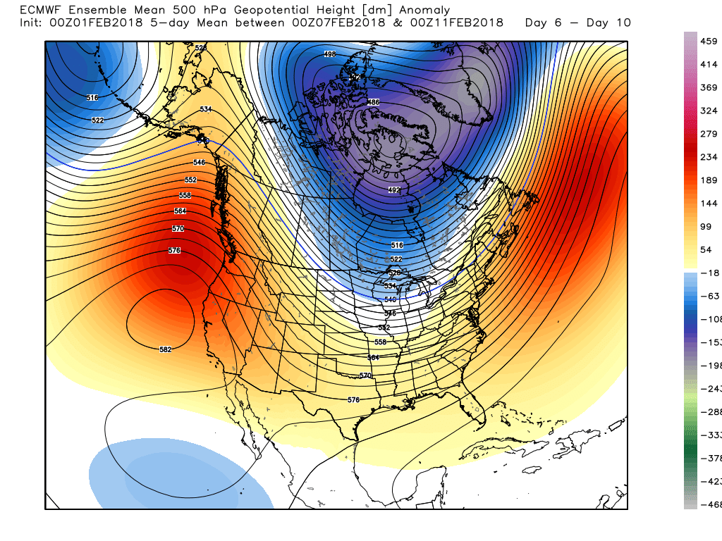
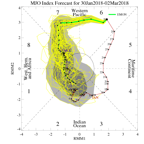
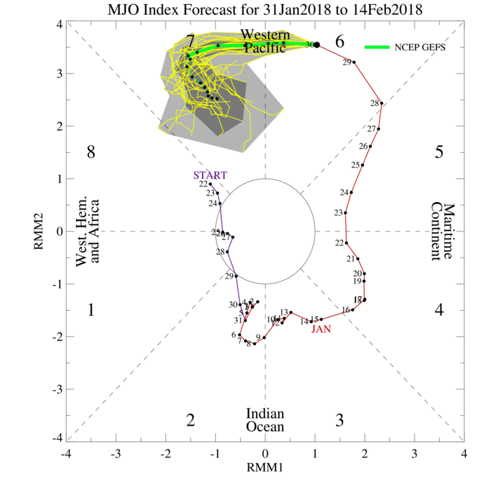
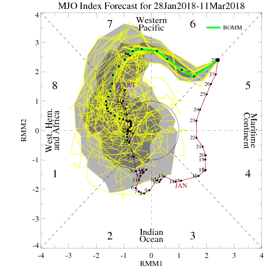
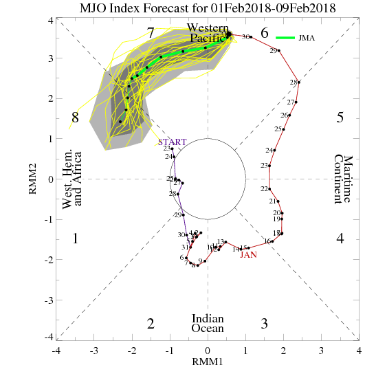
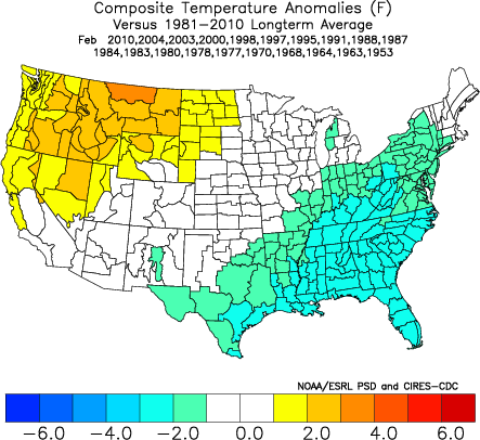
We're watching several different events to see how they are going to effect us here in the southeast. Let's take a look. MJO - The MJO has been moving at a snails pace as it heads toward some favorable cold phases for this time of the year. The amplitude of the MJO has been pretty extreme which can help to cause wide swings in the weather. Right now the MJO is in Phase 7 which is a warm phase, but it looks like most of the models want to head into phase 8, 1, 2, 3, which are all relatively cold phases for us in February and March. However, some of the models have backed off on the strength of the MJO and even take into the neutral area, so we will need to watch to see how this progresses. MJO forecast are not the most accurate at a distance. All of the MJO maps and data can be found at this link: http://www.daculaweather.com/4_mjo_phase_forecast.php
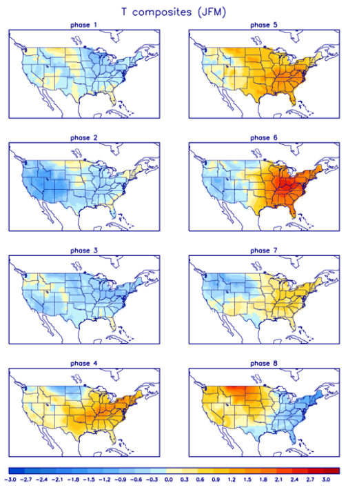
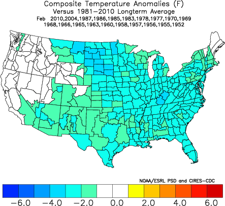
Temperature composites showing the expected temp outcome for JFM depending on the phase of the MJO
Stratosphere -
There are signs that there may be a stratospheric warming event on the horizon, and that is good news if you like the cold and want more winter. Instead of me trying to explain the complexities of a stratosphere forecast, I'll let the following Tweets speak for themselves. I have a full compliment of stratosphere maps and forecast at DaculaWeather.com. From the menu at the top, click on "Models", and then "Stratosphere Model Data".
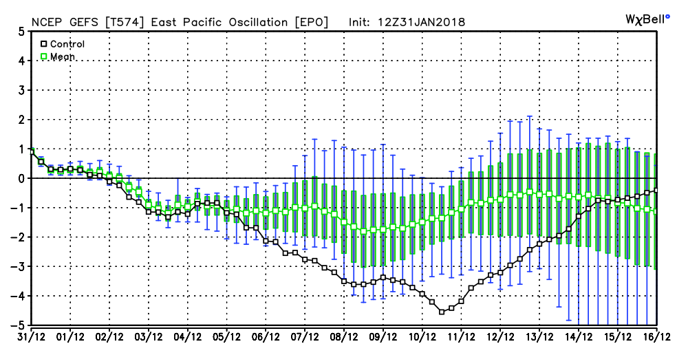
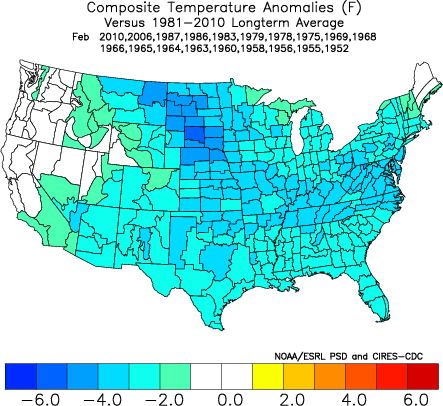
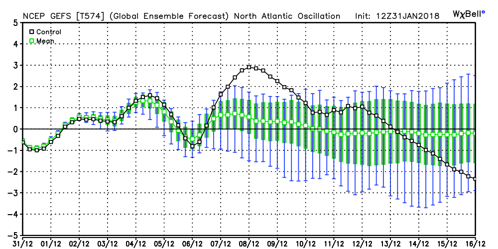
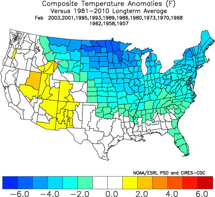
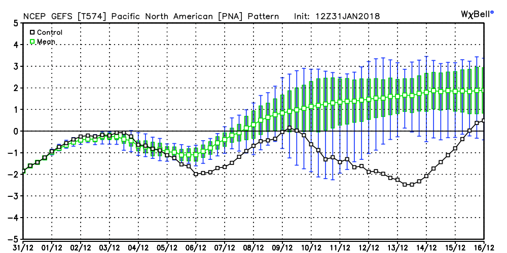
Teleconnections -
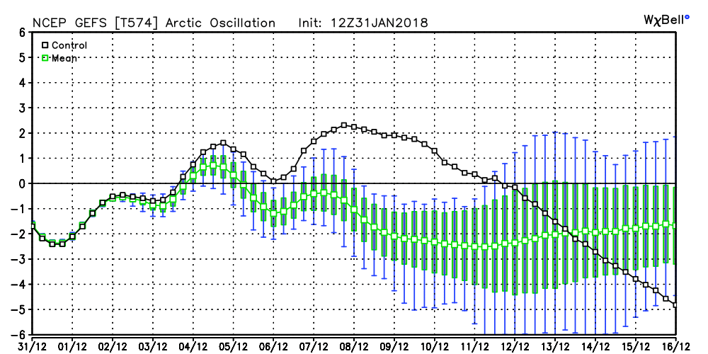
I've talked about teleconnections before, so let's talk about how the models see all of this playing out. As you may know, teleconnection indexes are simply measurements of the different patterns in the atmosphere, and during certain times of the year like in the winter, they are particularly important in defining when and where the cold air may go. The Euro has been a little indifferent in the strength of these indexes but the GFS ensemble is beginning to show some signs of major high latitude blocking. The top row of images are the current readings and the forecast, and the corresponding images in the bottom row show how the temps normally respond. The first image shows the AO going negative, the second the NAO going negative, the third image the EPO showing a tilt toward negative, and the last image is the PNA possibly heading to a positive state. You can find much more about these 4 teleconnections from the following links at http://www.daculaweather.com:
Bottom Line -
All signs are beginning to point to a change toward a cold period beginning is two weeks or less, and continuing into March. One unknown is the outcome of the stratospheric event and whether or not we can get the high latitude blocking that we need here in the southeast, and another unknown factor will be the timing of the phase and strength of the MJO. Whether or not we have precipitation to go with it is still unknown, but you can't have winter weather without cold air and it doesn't look like cold is going to be an issue. |
Archives
March 2019
Categories
All
|
OLD NORTH GA WX BLOG
 RSS Feed
|
Never base important decisions on this or any weather information obtained from the Internet. Always have a backup method of receiving weather information such as a battery powered weather radio.
Copyright © 2018 NorthGeorgiaWX.com and DaculaWeather.com 
|