|
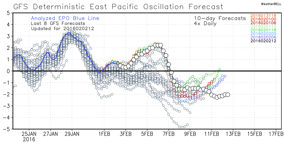
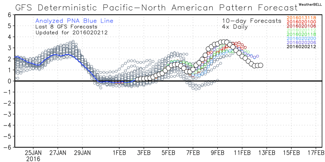
I wanted to take a look at the Euro ensembles and attempt to show you some issues that may or may not bring us some winter weather, but more to show you some of the things that have to be considered this far out. There are so many things that can go wrong that would keep us from getting frozen precipitation here in Georgia, and there are a million details that can mess things up when you get close to the time of the event, but in this post, I wanted to touch on the larger scale features that can lead to a winter storm... or not. Here's the first image. I've circled two pieces of energy that we are focused on, one dropping down from the northern stream, and the bottom one riding along the southern stream. Ideally, what we would like to see is the two pieces join or "phase" together and make us a nice big bowling ball storm that rolls along the Gulf coast... at least that's the idea we need to make a big snow storm. 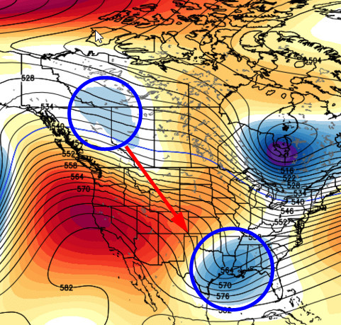 A couple of things to note here. One, we have good blocking out over the west coast, this is a +PNA/-EPO ridge, which is exactly what we need to slow down the flow off of the Pacific, the the GFS teleconnections are showing just that (see images below). I would prefer to see the ridging more vertical (versus the yellow line), because the way it's depicted by the model tends to make the energy dropping down from Canada slide more east than south, and you can see how far east that ridge is. In the ideal world, the lower piece of energy would be further west and the northern piece would drop more south toward Texas. So at least on this run... the timing and position is not there. 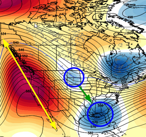
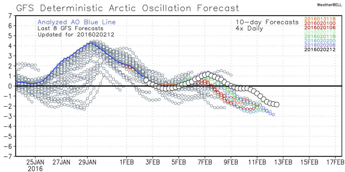
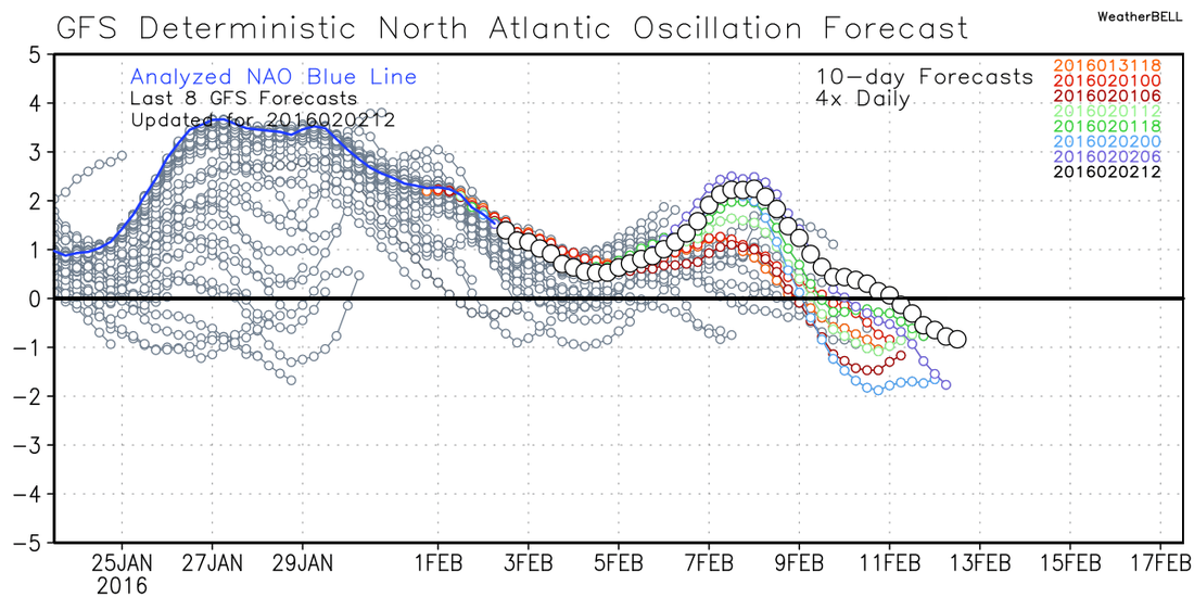
As the EPO and PNA do their dirty work, the AO (Arctic Oscillation) and NAO (North Atlantic Oscillation) are also forecasted to go negative, which are all positive (no pun intended!) signs for locking in some cold air and providing some chances for frozen precip.
In this next frame, you can see the two pieces beginning to merge or phase. The bad part is that the lower bundle of energy is too far out in front and the upper wave is too far east, so the timing and position is just a little off, at least as it appears for us in Georgia. 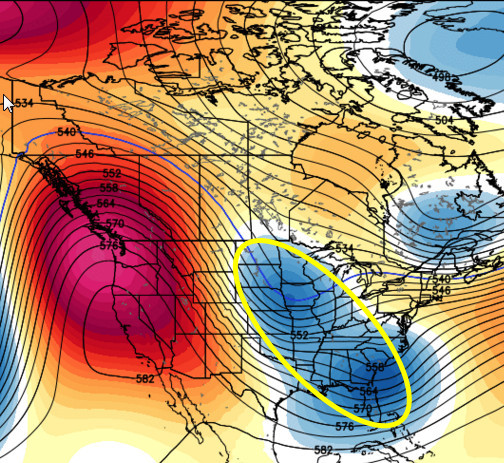 Here, the two pieces have merged and we now have one larger system. Wonderful you say? Not so quick... and here's the problem. The strongest part of the trough is now over Missouri, when for us, it needs to be along the Gulf coast. At this stage of the game, this looks more like a clipper type system versus the Miller A that we want to see. 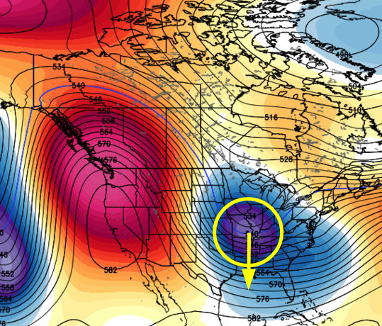 In this final frame, the two pieces have now completely merged and you can see a much stronger and larger trough. Still... since the timing was off, the trough is still trying to strengthen as it begins to rotate and pull away. You can see that it still has a positive tilt as it moves across Georgia and we would ideally like to see that as a negative tilt trough, or a tilt the other direction (top of line tilted to the left or west more). Couple that with the fact that the 540 line needs to be lower (and probably would be had it phased sooner), and you can start to see some of the things that can go wrong with this system. In this frame we still have good ridging out west which does help to slow things down, but it's the timing that is currently off. 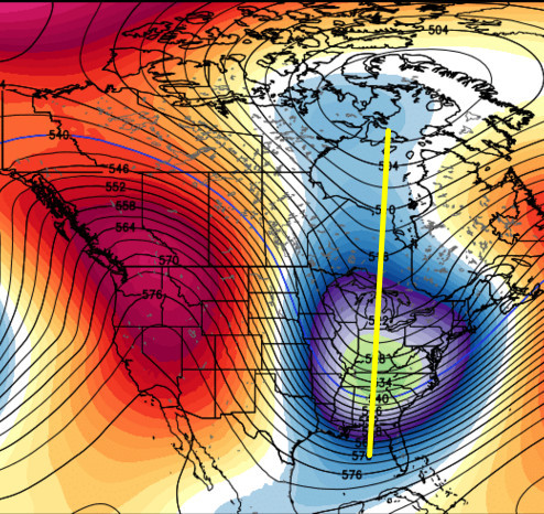 As you can see, everything on a big scale has to fall into place before the details can be determined, and it's never easy for us. This system will continue to evolve with every model run, we just have to hope it evolves in the direction that is favorable for us. There is still time for this to workout for us, but it needs to start shaping up pretty soon if it's going to happen. We are about 8 days away from this system, so not a lot of time to make corrections. Side note from Joe Bastardi...Before you leave here, I wanted to include Joe's thoughts about how he sees the remainder of winter unfolding, thoughts that he posted just a few minutes ago... The ridge coming back into western Canada was key to what cold there was in January. It is key to what cold there will be in February, too. The current warmup is around 10 days and the coming colder period 10-15 days. The following warmth will be another 10 days. |
Archives
March 2019
Categories
All
|
OLD NORTH GA WX BLOG
 RSS Feed
|
Never base important decisions on this or any weather information obtained from the Internet. Always have a backup method of receiving weather information such as a battery powered weather radio.
Copyright © 2018 NorthGeorgiaWX.com and DaculaWeather.com 
|