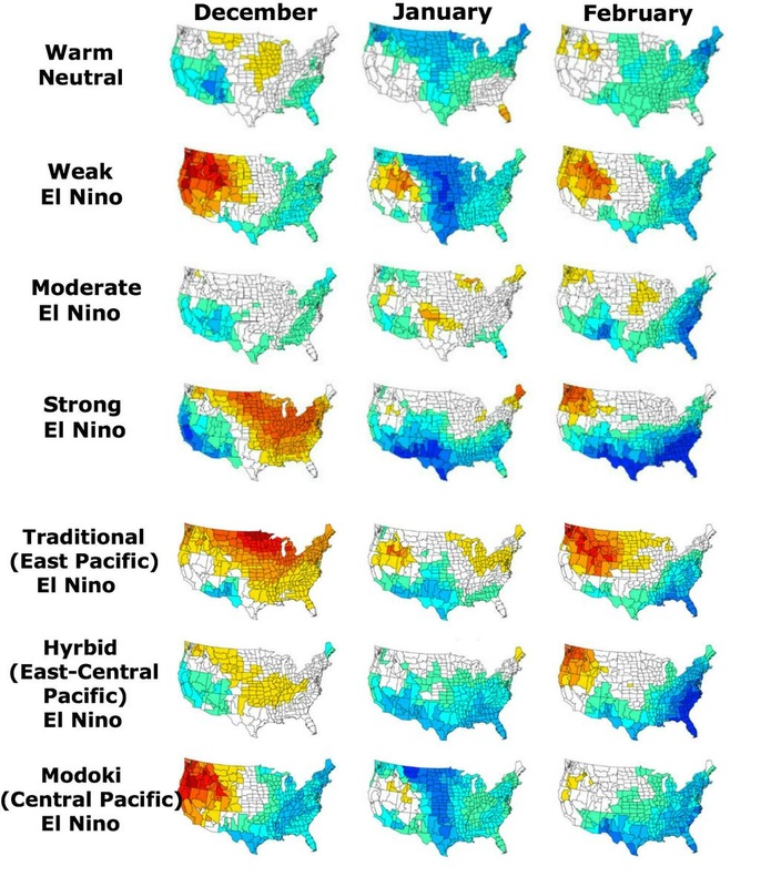
 US Monthly DJF temps in accordance to placement/strength of an El Nino... Typical Warm Neutral-Weak Hybrid Dec on tap. Image from Eric Webb (Click to enlarge) US Monthly DJF temps in accordance to placement/strength of an El Nino... Typical Warm Neutral-Weak Hybrid Dec on tap. Image from Eric Webb (Click to enlarge) OK at least the end to the warm weather that's been driving everyone so crazy. This is December and we all have visions of a white Christmas and sleighs being pulled through the snow. :-) OK, it's me that has those visions. For myself, winter is the best season of the year, assuming you actually get some real winter weather to go play in. I grew up in Nashville TN and we had a little more snow there than here in Atlanta. I can still remember all of the great late 60's and early 70's winters and the large snowfall events. We would stay out for hours and hours at a time, only coming in to throw the wet clothes in the dryer and to get something warm to drink, then grab the sled and back outside for more fun. Ahhh... the good 'ol days. So now people are getting antsy and starting to wonder if the much anticipated cold and snowy winter forecast that just about every meteorologist predicted is still coming? You haven't heard me talking much about the weather lately, but it's not because anything has changed, it's only because there really isn't much going on right now. Trust me... once we get cranking, you're going to get tired of hearing from me! The pattern that we've been languishing in was actually expected and pretty much follows the textbook example of how a late fall early winter weak Modoki El Nino would behave (see the image to the left). But now we're seeing signs that this is all about to change. I'll let Larry Cosgrove explain from his most recent post. After the barrage of seemingly endless computer model runs that indicated a long spell of mild temperatures across the continent, quite a few people who review or forecast weather threw out their winter forecasts. Out went the mostly "cold and snowy" descriptions, in came the terms of "blowtorch" and "balmy" for the DJF period 2014-2015. As I have often cautioned in releasing my predictions, outcomes shown by the numerical depictions are often short-term deviations from what eventually occurs. So as you can see, it appears we are just now entering the transition phase into winter that will last for about 2 weeks before we get into the heart of what still looks to be an awesome winter for us here in the southeast. I also want to include a forum post by a gentleman named Eric Webb (Twitter @webberweather). Eric has an astounding amount of weather knowledge and freely shares and educates at the same time. While this may be over the head of some, it still shows the amount of detail and knowledge that goes into predicting weather. What he is talking about here are stratospheric warming events, and how they contribute (or not) to the actual winter weather on the ground. We have had a minor warming event already, but there are signs that a new SSW event may occur toward the end of the month. Sudden stratospheric warming tends to disrupt the Polar Vortex and, depending on the strength or the warming, can even change the flow of the stratospheric winds from east to west. This disrupting of the Polar Vortex cause high latitude blocking to form and can cause very cold air to spill into the lower 48 states. Not necessary for cold weather, but rather icing on the cake. I should mention that since the satellite record only goes back to 1979, thus we're working with a very limited dataset and in general, a statistically significant and confident relationship between the variables may not be easily attained. Also keep in mind the stratosphere is not necessarily a cause of the pattern but merely a reflection of largely the background intraseasonal-interannual forcing (with some room for persistence on longer timescales), especially from the troposphere and you can throw some outside solar and QBO influence into the mix. However, as you'll see below, I don't think it's a huge loss whatsoever if we don't see a SSWE, (even though I'm definitely in favor of an event occurring within the next several weeks) after all, the robust +PDO/El Nino combination we currently have is one of the most favorable base states regardless of AO/NAO, etc. for the southeastern US... 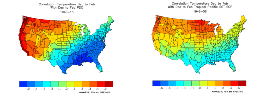 Image from Eric Webb Even if we don't see an event, we're still more than likely going to end up below normal temperature wise for the winter as a whole despite that December (as anticipated) was relatively mild/seasonable. In fact, looking at all the El Nino years with a +PDO in Sept-Oct (1902-03, 1903-04, 1911-12, 1913-14, 1918-19, 1923-24, 1925-26, 1940-41, 1941-42, 1957-58, 1958-59, 1965-66, 1969-70, 1972-73, 1976-77, 1982-83, 1986-87, 1987-88, 1991-92, 1997-98, 2002-03, 2004-05, 2009-10) only 3 out of the 23 events (1991-1992, 1997-1998, & 2004-2005) were above normal in the southeastern US in both January and February using the 1895-2000 climatological base period. That equates to about 85-90% of +PDO El Nino years having at least January or February colder than normal, ~70% of those years (1902, 1904, 1912, 1924, 1941, 1942, 1958, 1966, 1970, 1973, 1977, 1983, 1987, 1988, 2003, 2010) were colder than normal in both January and February in the southeast. I like those odds... 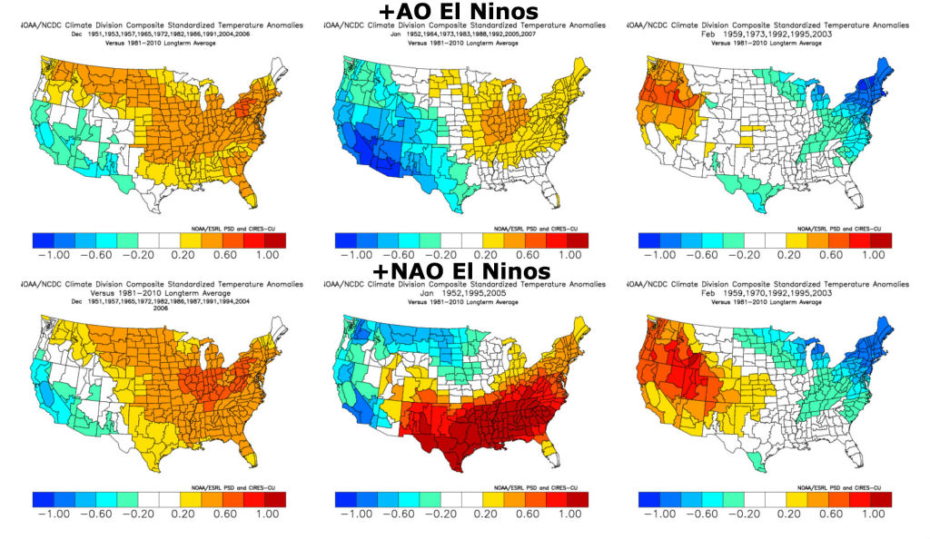 Image from Eric Webb All forcing mechanisms aren't necessarily created equally and you likely wouldn't know this tidbit about +AO/NAO's in an El Nino by simply looking at the US PSD temperature correlations for the NAO/AO, which both max out with a positive correlation of ~.5 to February temperatures in the southeast while NINO 3.4 & Tropical Pacific SST EOF only come to about .4 & .3 respectively. Superficially it seems temperatures should be above normal in such a pattern, but this is clearly not the case..  Image from Eric Webb 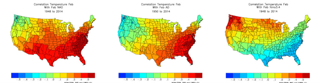 Image from Eric Webb Now, looking at the AO/NAO indices and how they stack up, I found little to no correlation in the winter as a whole (that doesn't mean that one isn't there, and we know from observing events like Jan 2010 & December 1984 that a SSWE has the capability to strongly modulate the Northern Annular Mode for at least a few weeks or so at a time, and I would likely best describe the forcing from stratospheric warming similar to solar i.e. elusive, although not nearly to that extent.) There's no doubt we need perhaps a few more decades of data at the very least before serious research can be undertaken. What surprised me a bit was that El Ninos without a stratospheric warming event actually had a lower overall seasonal AO. It's clear to me in looking over the data which I've shown below, it's not impossible to see a month or two with a huge -AO even though we don't see a big warming event, this is evident in January 1979, 1998, February 1988, and March 1980... 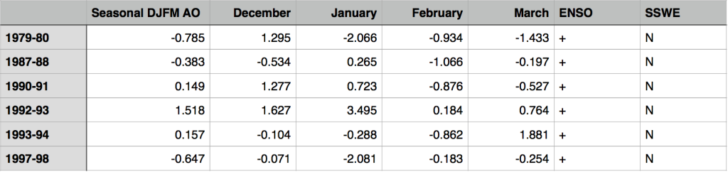 +ENSO Years AO w/o a SSWE (Image from Eric Webb) The same can be said for warm ENSO years, there were quite a few positive months in this regime, in fact, take the winter of 2002-03 for example, we had a decent SSW event in January, which didn't do much, if anything to the AO... 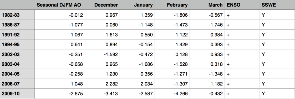 +ENSO Years AO w/ a SSWE (Image from Eric Webb) Now here's the NAO data... 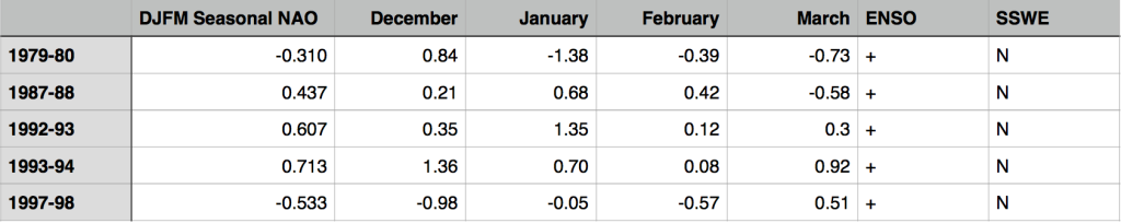 +ENSO yrs w/o a SSW event, 1979-80 (one of the warm neutral-weak hybrid El Nino analogs) looks to do perfectly fine without a stratospheric warming event. (Image from Eric Webb) 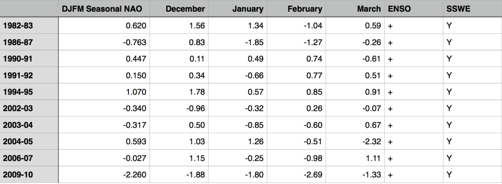 +ENSO yrs w/ a SSW event (Image from Eric Webb) Levi Cowan also made a very nice video a few years ago in the winter of 2011-12 during what even I would willingly quantify as a blowtorch about stratospheric warming events and ENSO. It's not difficult at all to get cold into the eastern US following a SSW event in an El Nino, La Ninas on the other hand as he mentions, with help from the cold PDO, often resist cold from a SSW event, but there are exceptions like 1984-85 & 1998-99... 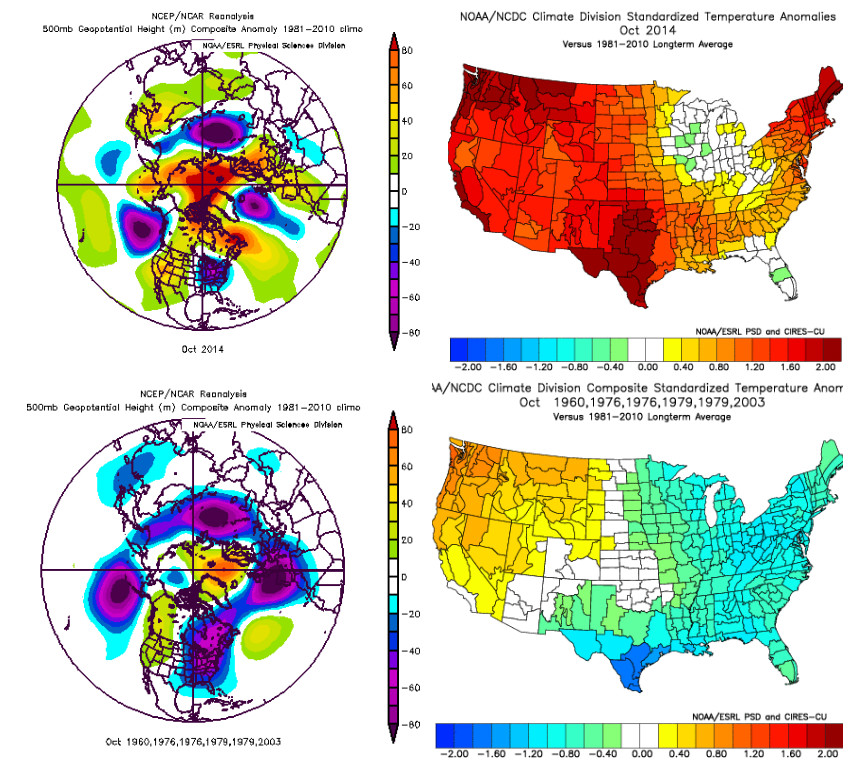 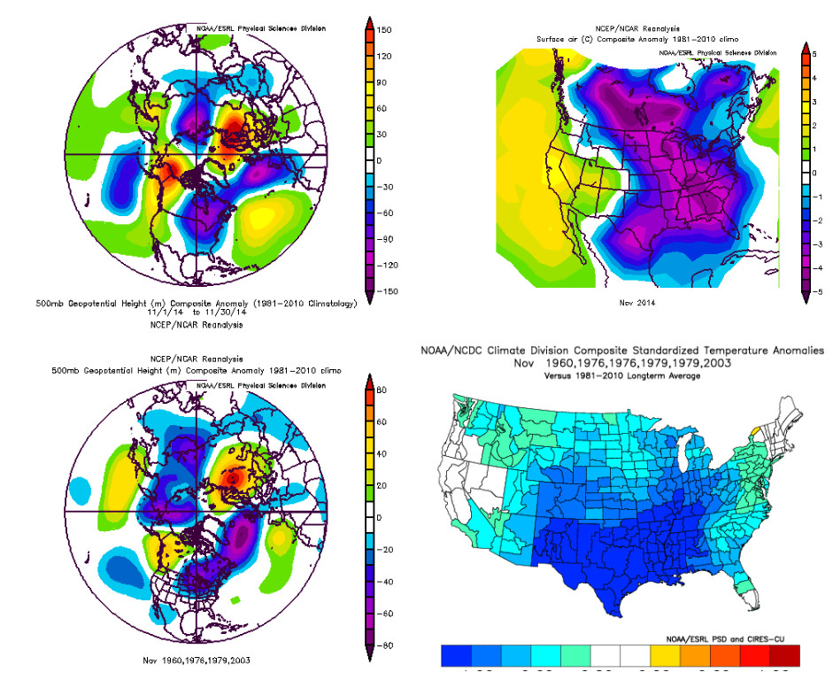 Well... if you made it this far down the page, you should be much more weather savvy than when you started! You can also see we are just beginning to enter the fun times that await us this winter. You going to be hearing much more about this starting this week coming up, but certainly the following week (12/14-12/21).
Can't wait! :-) |
Archives
March 2019
Categories
All
|
OLD NORTH GA WX BLOG
 RSS Feed
|
Never base important decisions on this or any weather information obtained from the Internet. Always have a backup method of receiving weather information such as a battery powered weather radio.
Copyright © 2018 NorthGeorgiaWX.com and DaculaWeather.com 
|