 Temp Anomalies for Sunday Temp Anomalies for Sunday
Well, at least I have a few alternatives for posting information. Starting today I will be making these consolidated "daily" post. They will contain everything that I would normally share in a day, all rolled up into one post. Who knows, it may be easier for you to read instead of wading through multiple post. But this will mean that you will have to come back here to get the updates. I can post a comment on FB when I do an update, but that's about it.
This consolidated post will be ordered with the most recent update at the bottom and I will time stamp each update for you. All I ask is that if you like the post, to please click on the Facebook button at the bottom to "Like" it. Since the Facebook page isn't working, new followers will be harder to come by, so those likes will go a long way in helping me out. Thursday, 8:33 am
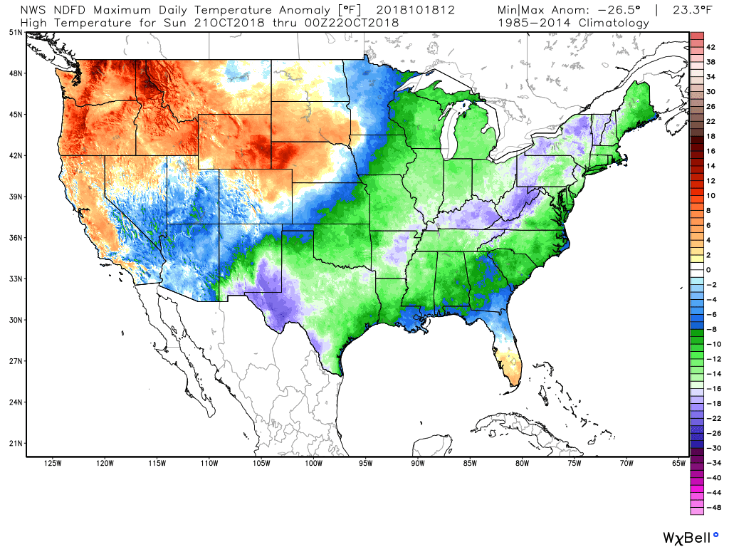
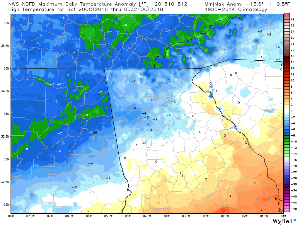
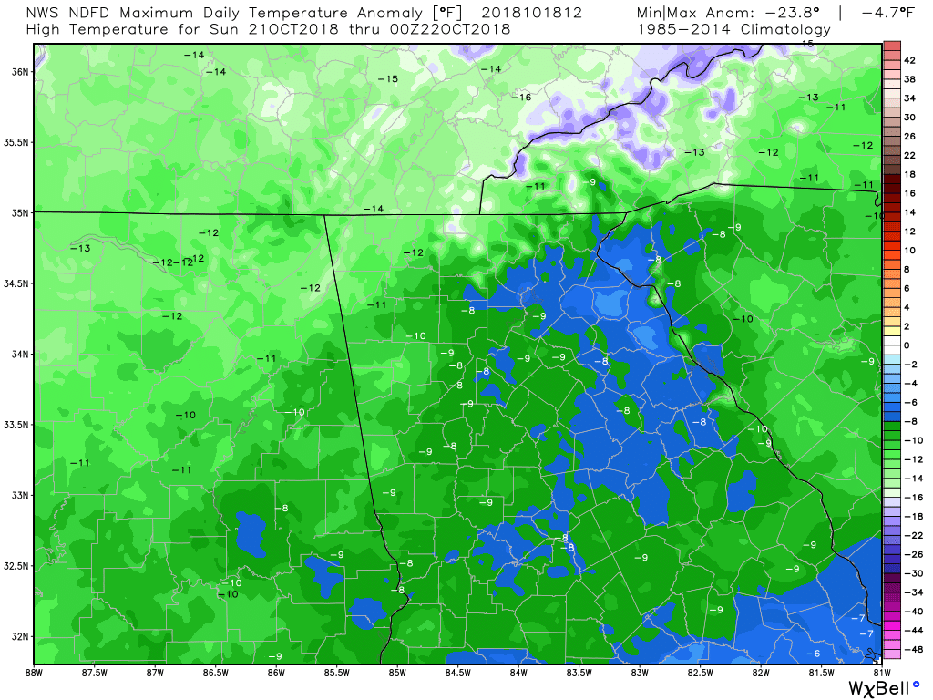
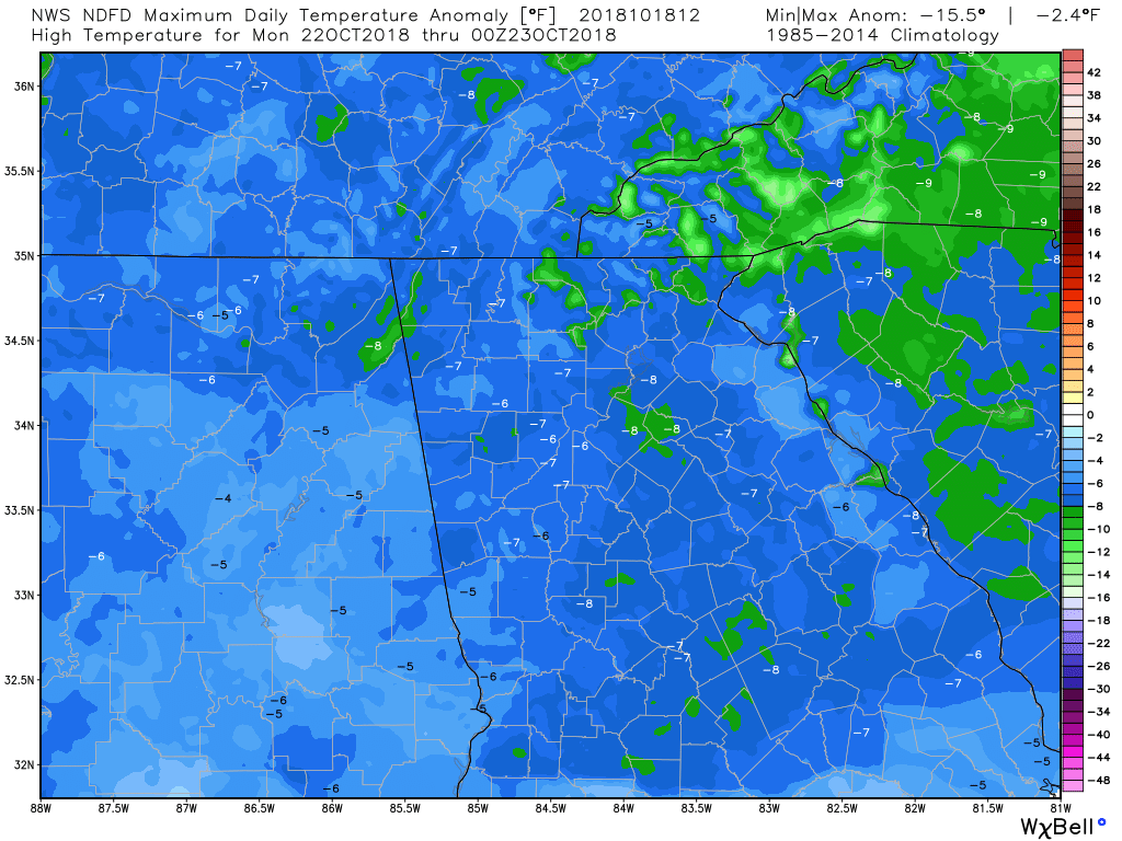
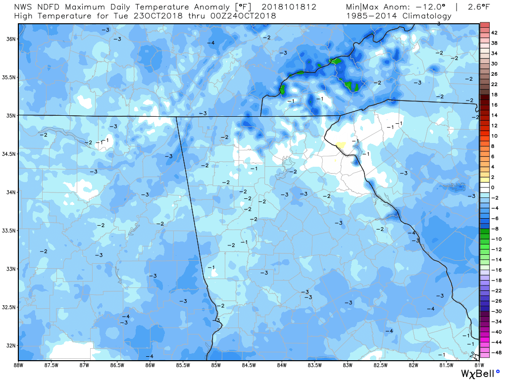
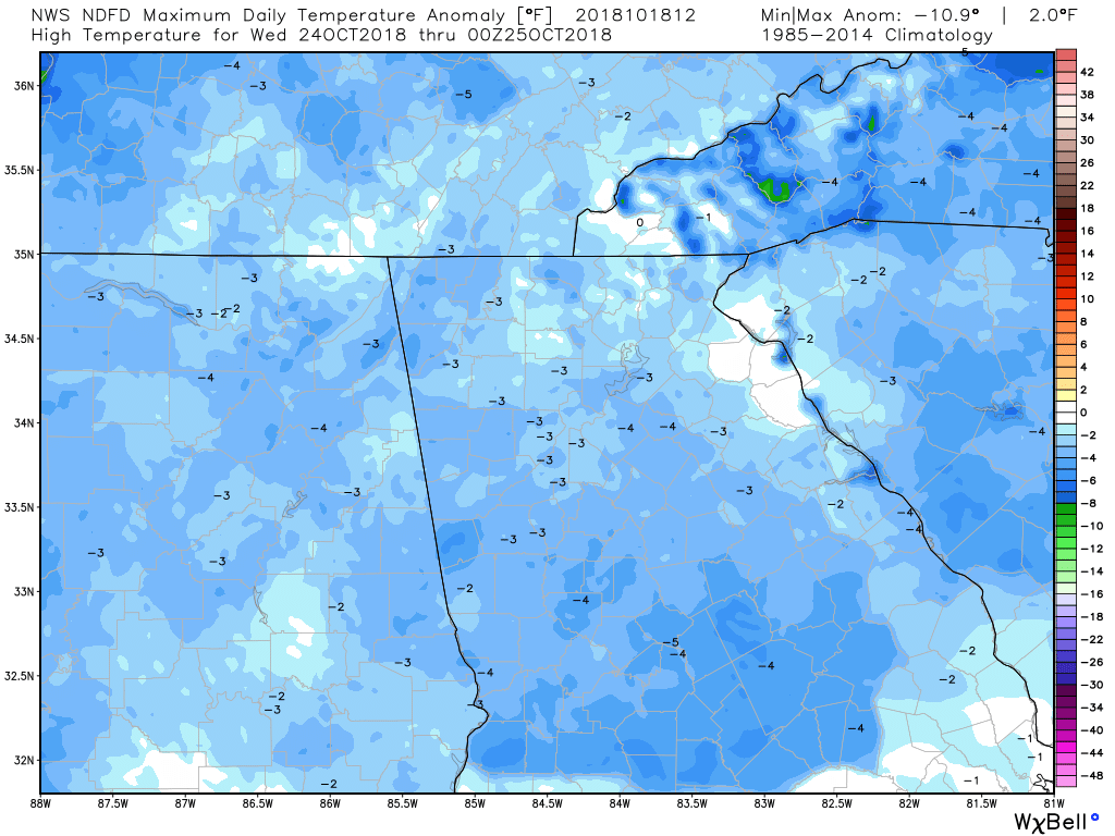
If it doesn't feel like fall for you yet, it will very soon. It's looking like our high temps will be below normal for about a week. With rain coming in on Saturday, we'll see a little bump up, but still below normal. The six images below are the high temperature anomalies through Wednesday, and as you can see, we will finally get a week of BELOW normal temps instead of above.
Thursday, 9:05 am
Blocking events are what helps to push the cold air south. And speaking of cold air, the very NW corner on NC and NE corner of TN could see a flake or two of snow. Fun times ahead! :-)
Thursday, 10:12 am
Here's another story on the crop losses in Georgia due to Hurricane Michael, and the losses are estimated to be in the neighborhood of 3 billion dollars.
https://www.ajc.com/news/hurricane-michael-damage-billion-georgia-agricultural-losses/TLLCf5XpCsnJvMAhWZE8cI/ Thursday, 11:26 am
Thursday, 12:13 pm
Animated GIF showing the 10 day temperature anomalies from the 00Z Euro operational run.
Thursday, 1:43 pm
Here's the Weekly Weather Briefing from the Atlanta NWS office.
Thursday, 2:48 pm
Whoa!!!
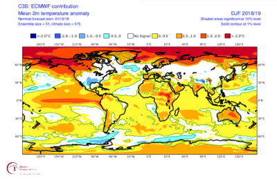
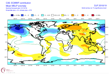
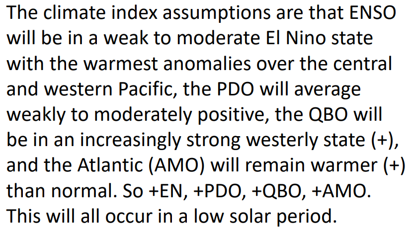
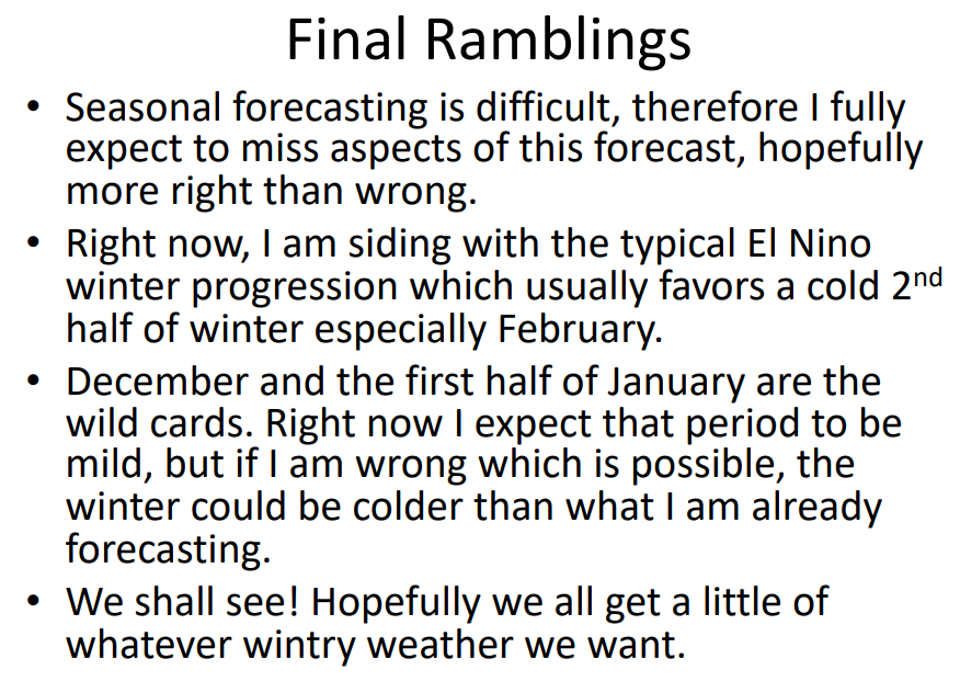
I thought I would keep a list of all the winter forecast that are being made for the upcoming winter. Where I can, I'll include the links so you can go read the forecast for yourself, and for others I will include maps and images. I will update this list when I find a new forecast, so please keep checking back. The forecast will be ordered by the date they are issued or when I find them. :-) Weatherbell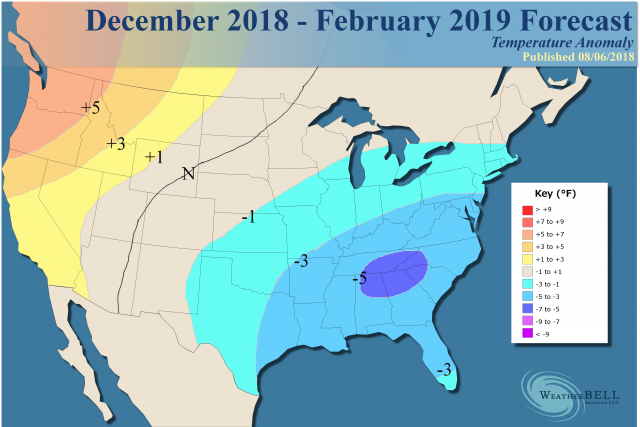 Issued August 6 Forecast updated September 27 with no changes I've already made a blog post for WeatherBell's winter forecast as they were the first (and always the first) to issue one. Summary 1) - Forecast remains unchanged from August 6 issuance. 2) - Major cold and stormy winter is in the cards. 3) - Could simply evolve into it from fall. 4) - Coldest air could wind up over much of the U.S. this winter. "Cold is fighting back, and where large-scale cold does show up this winter it is likely not to take prisoners. There is plenty of reason for blocking to take place, given the increase of water vapor due to the overall warmth of the oceans of the past 20 years and still trying to wash out the Super Niño (minute increases in water vapor lead to quicker saturation and condensation and release of heat, hence the blocking over the pole). Solar activity and the QBO are even more variables that should lead to increased blocking, which in the end causes longer duration cold over the mid-latitudes. Arguments over the entire cause of that is best discussed elsewhere, but I am sensitive to where we are and do think it must be dealt with. The bottom line here is I would be looking closely at the winter of 2002-03 and 2009-10 as that is where it could go, but the blended four analogs are where we are now." Click HERE for the link to the blog post. 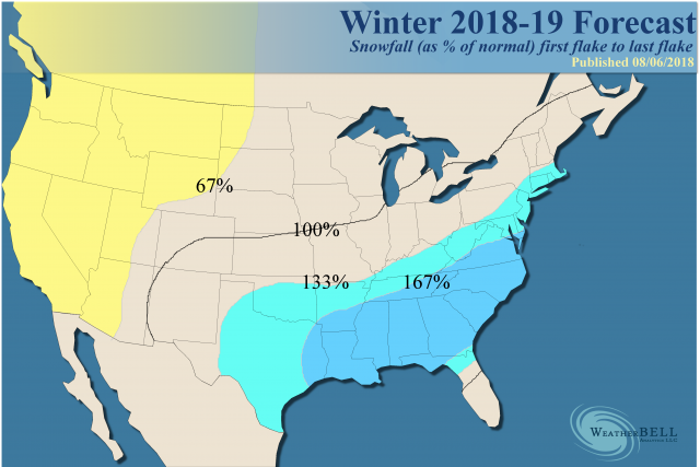 Perspecta Weather - Meteorologist Paul Dorian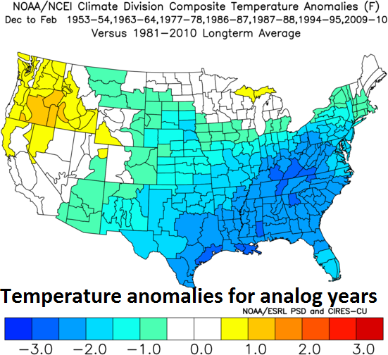 Issued October 10 Summary "Several key factors have been examined for the “2018-2019 Winter Outlook” and they suggest to me that this will be a cold and snowy winter in much of the eastern and southern US" "A detailed analysis of many different factors suggests to me that much of the eastern half of the nation should experience a colder-than-normal winter with more snow than normal. Coastal storms in the eastern US will be much more of a threat this winter as compared to last year when La Nina conditions dominated in the equatorial Pacific. Overall temperatures in the Mid-Atlantic region are likely to end up about 1.5-3.0 degrees (F) below-normal for the winter season and perhaps an even more dramatic chill will take place in the Southeast US where overall temperatures may average several degrees below normal. Snowfall is likely to be at least ten inches above the normal amounts in the Mid-Atlantic region this winter season which could result in 25+ inches in the DC metro region, 30+ inches in Philly and 35+ inches in New York City. Unlike some recent winters, this season is likely to get off to a quick start with some notable cold and snow in the month of December. Much of the western third of the nation is likely to experience warmer conditions relative-to-normal; especially, in the Pacific Northwest where it could be several degrees above normal. Precipitation amounts this winter season in the western third of the nation are likely to be near normal to slightly drier-than-normal." Click HERE for a link to the forecast 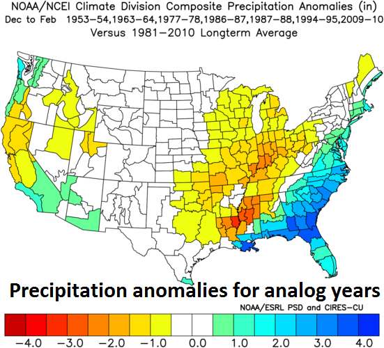 East Coast Weather Authority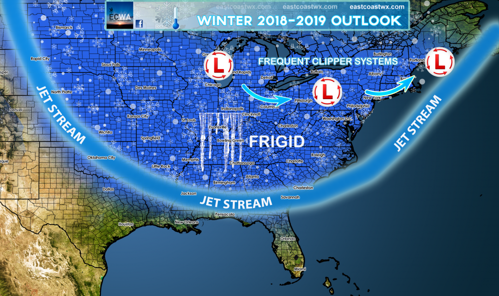 Issued October 2 "Winter of 2018-19 is expected to be well below normal with a frequent northern storm track. If you recall in the Northeast, during the month of December in 2002 there was monster Christmas Day blizzard, also record-breaking blizzards in February as well. This winter looks to mimic 2002-2003 with cold outbreaks and major winter storms as we are very confident in this forecast due to all signs leading in that direction." Click HERE for a link to the forecast My Note: Much of the language here matches Weatherbell's wording. AER - (Dr. Judah Cohen)Issues October 18 When Dr. Cohen issues his forecast today, I will post it here. In the meantime, this is his look and take at the Euro Winter forecast. Bold text is my highlight. "With that caveat of the benefit of ignoring model forecasts, I present what is I believe is the latest European Centre for Medium Range Weather Forecasts (ECMWF) winter forecast taken from climate.copernicus.eu. The ECMWF model is generally considered the best forecast model on the planet. The first thing that jumps out at me is the predicted classic or text book positive Pacific North American (PNA) pattern with a deep Aleutian Low, ridging or elevated heights across northwestern North America including Alaska and troughing or low heights in the Southeastern US. The ECMWF model is also predicting a quasi-negative NAO with the southern pole or center of action more classically represented than the northern pole. But in regards to the US winter this represents a suppressed storm track along the Eastern Seaboard. A positive PNA should yield an overall cold winter to the Eastern US. The ECMWF model is most confident in a relatively cold winter in the Southeastern US with greater uncertainty in the Northeastern US while the suppressed storm track will bring elevated risks of East Coast snowstorms. And El Niño does tend to focus the greatest snow threat, at least relative to normal, in the Mid-Atlantic. If you are a winter weather enthusiast especially a snow lover living in the Mid-Atlantic this ECMWF winter forecast should have you very excited. The other feature that jumps out at me is high latitude blocking. I already mentioned the blocking near Alaska but there is a second center near Scandinavia that extends eastward into the Barents-Kara Seas. If the ECMWF was predicting a textbook negative NAO this block would be closer to Greenland. I believe that if the ECMWF forecast is correct and the block sets up near Scandinavia this is not as cold for Europe as the classic negative NAO but would instead focus the cold more in Asia. However I do think some of that cold would likely be drawn eastward underneath the blocking high and could result in a cold, possibly snowy winter for Central and/or Southeastern Europe. The other thing to watch is that a blocking high near Scandinavia and the Barents-Kara Seas coupled with a deep Aleutian Low is ideal for transferring energy from the troposphere into the stratosphere forcing a PV disruption. Now I don’t believe the ECMWF forecast is a consequence of a polar vortex disruption but is strongly suggestive of one. And if one does occur, then I would expect an increased probability of a more classic negative NAO to follow. As we showed in Cohen and Jones 2012 Figure 1 – Scandinavian blocks precede major PV disruptions and Greenland blocks follow major PV disruptions."
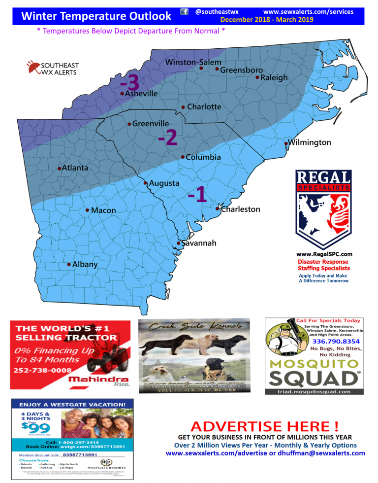
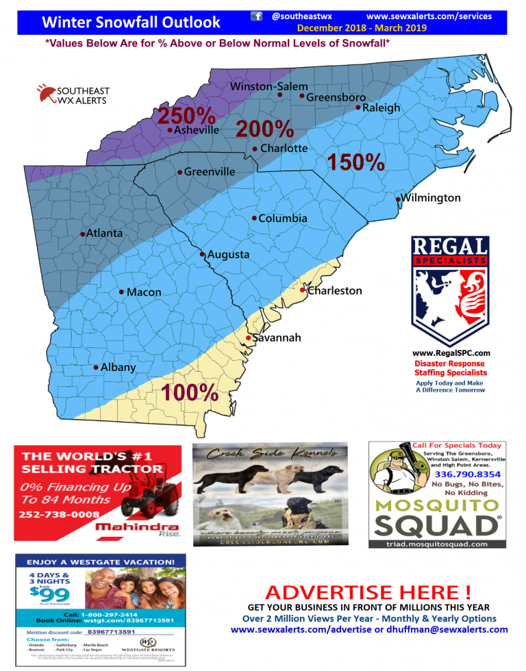
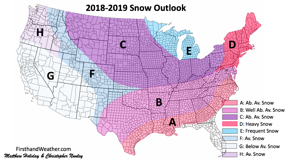
Southeast WX Alerts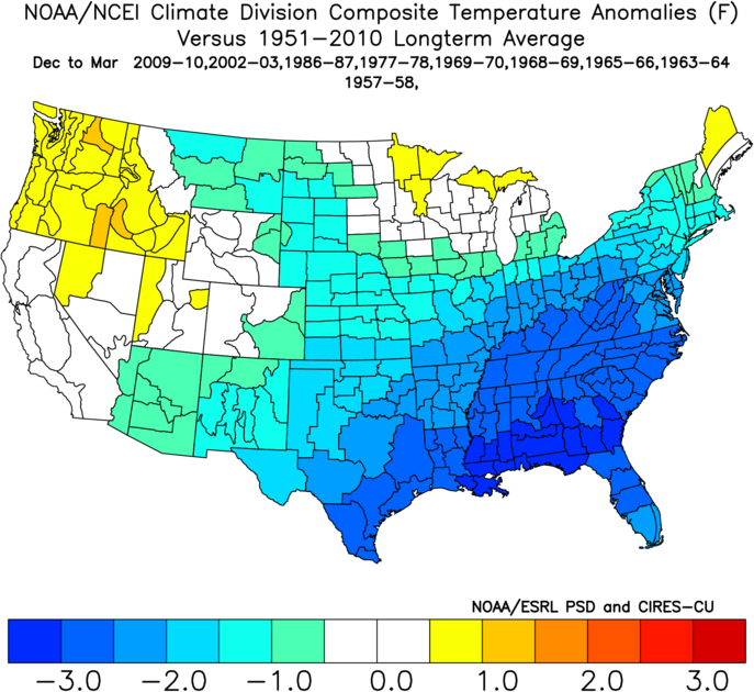 Analog Temperatures Analog Temperatures Issued October 19 Summary The winter of 2018-2019 is shaping up to be one of the coldest and wettest in a decade. This winter is contingent on a few major drivers, which is the progression of a weak EL Nino, blocking in Greenland and ridging in the Western USA. Conclusion Winter forecasts are made up of several different aspects and it is kind of dependent on many factors. However, if you can get the right timing then it is still possible to have a major winter storm in the right conditions. You must look at all the factors involved and understand that if one does not line up with another then more than likely it will not produce winter precipitation. IF, you are only going to look at one factor then your forecasts will be flawed anyway. What I favor is for all three (+PNA, -EPO, -NAO) of these indexes to line up many times through the winter. With that in mind, expect this winter to produce between 150-200% above normal snowfall in most of the Southeast, with some areas seeing as much as 300% above normal (Refer to map above). To get the % you will simply take the normal snowfall amount and multiply it by the % amount. Some areas in the NC Mountains could end up with 85″ + of snowfall at season end. This will make the ski resorts very happy. The only exception of snowfall will be extreme South Georgia and Florida, where it will be closer to normal. However, I expect for Northern and potentially even Central Florida to see some type of winter precipitation before the winter season ends. See the custom map at the very bottom for my thoughts on the 2018-2019 winter. Click HERE for a link to the full forecast
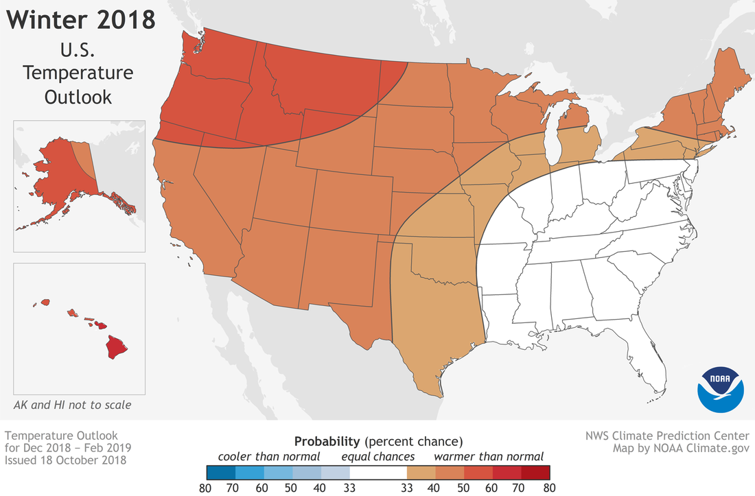
NOAA Winter Forecast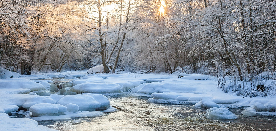 Issued October 18 Temperatures
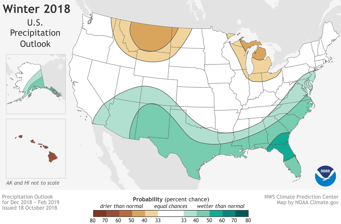
Precipitation
Kirk Mellish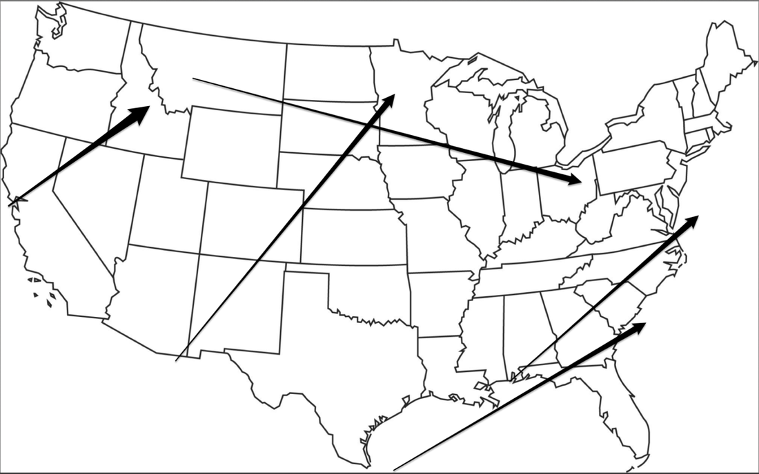 Anticipated Storm Tracks Anticipated Storm Tracks Issued October 17th PRELIMINARY BOTTOM LINE: As for me, at this point I see a 3-4 month average that features temperature below-normal and rainfall above-normal, with above-normal odds for snow and/or ice. I would favor January-March for the bulk of winter weather despite many analogs saying it starts in November or December. Remember, this is the average of the 3-month period it does not mean every day or every week.
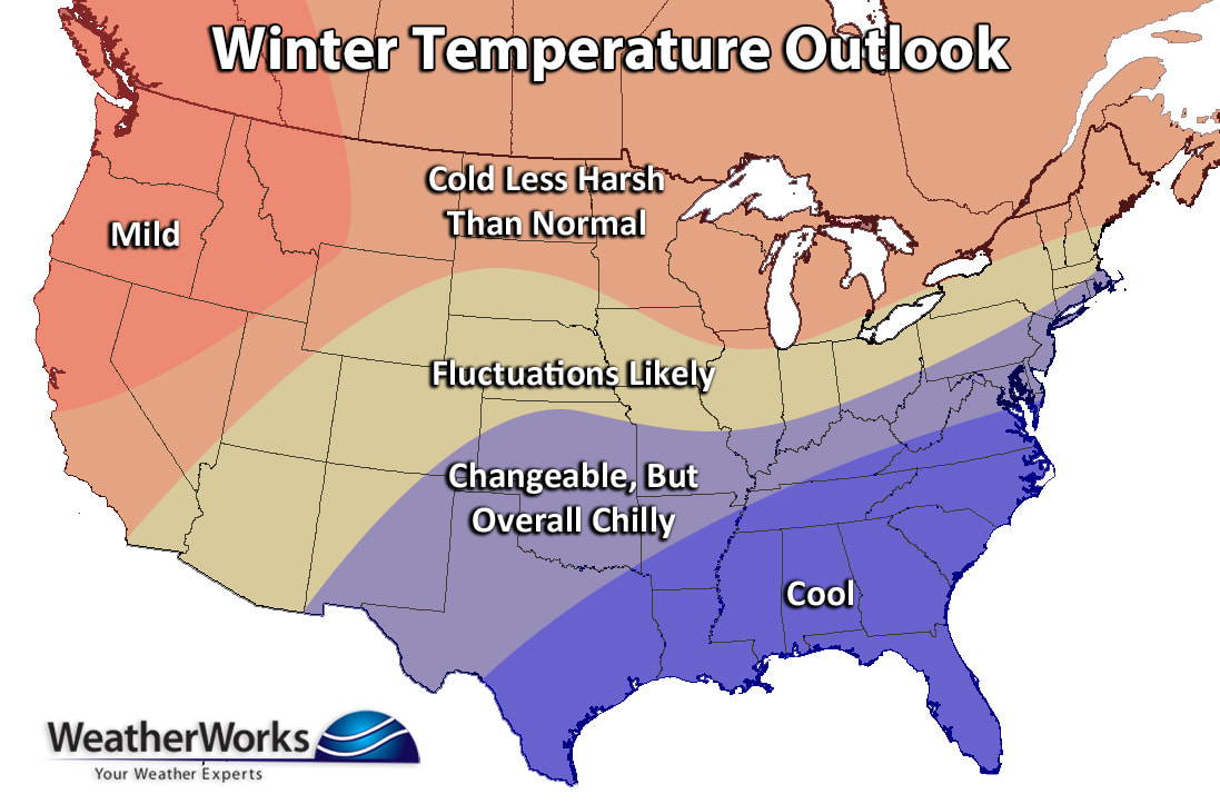
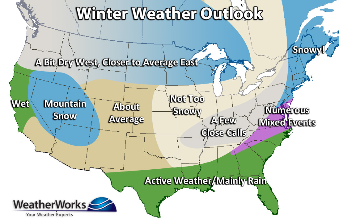
WeatherWorks Issued October 23rd In general, the expected pattern will promote a warmer than normal western half of the U.S. with some of those above normal readings bleeding into the northern Plains and the Great Lakes. Colder than average conditions will be expected from Texas through the Southeast U.S. and into the mid-Atlantic & southern New England. As for snowfall, look for above normal snow in the Intermountain West, average snow across the Great Lakes, and above normal snowfall from eastern PA and NJ northward into New England & Maine due to a storm track along the coast. The Midwest will likely miss the majority of the big storms along the eastern seaboard, but will still have a good bit of smaller events from clippers. However, the region will end up slightly below normal in the snowfall department. Wet weather can be expected in northern California and across the Gulf states as the southern jet stream will keep things active. More specifically for Northeast U.S., the first half of December will be chilly, but the coldest period will be from the end of January through February and into early March. Even though this seems like a long duration, it won't be cold straight through winter. We think a good bit of November and the end of December, near the holidays, will be rather mild... which might ruin white Christmas prospects for many. This mild stretch could even last into mid-January. Although the interior and northern mid-Atlantic into New England will be favored for some snow early in December, the snowiest period will likely be from February into early March. This period will be the best window to see "the big one" as nor'easters will be distinctly favored due to the active southern jet stream providing moisture, and a predominantly -NAO state guiding the storm track up the East Coast. In New England, strong instances of high pressure may work against an overly snowy year and suppress a few storms to the south. Either way, this should be an interesting winter season to say the least. Click HERE for the complete forecast
Firsthand Weather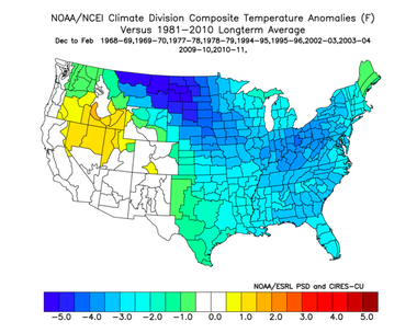 Issued October 29th B (Dallas, TX; Oklahoma City, OK; Little Rock, AR; Jackson, MS; Birmingham, AL; Atlanta, GA; Greeneville, SC; Charlotte, NC): This region will be characterized by temperatures below average and precipitation above average. This region has the opportunity for several winter storms to provide snow and ice opportunities. 2018-2019 Winter Outlook Conclusion The 2018-2019 winter will feature below average temperatures for southern and eastern parts of the United States. Above average temperatures are expected for the the Pacific Northwest. Precipitation will be above average for southern and eastern parts of the United States. The above average precipitation will lead to seasonal snowfall totals above average across the Southern Plains, Southeast, Mid-Atlantic and the Northeast. Please keep in mind, if your region is in an area with above average temperatures, this does not mean wintry precipitation will not occur Click HERE for the full forecast
Allan Huffman Issued October 31st Allan is expecting February to be brutal... please read his forecast! Click HERE for the full forecast
Larry Cosgrove Issued October 31 Predictions:
Caveats
Click HERE for the full forecast DT from WXRiskIssued November 2 Friday Weather Summary Keepin' it simple today. If you enjoyed the weather yesterday, you'll enjoy today. Fog, drizzle, and showers return to parts of eastern Nebraska and southwest Iowa today through 1pm Saturday. Northeast Nebraska could stay dry with light rainfall amounts farther south from trace-0.25". Cooler highs in the 60's and 70's through the weekend.  Closing for this year...While I know everyone didn't enjoy the weather, I hope everyone enjoyed the weather updates. If you would like to see this again next year, let me know on the page or here. As you know, weather can cause major issues for events like these, and I'd like to see everyone stay safe and return again next year, hopefully with better weather.
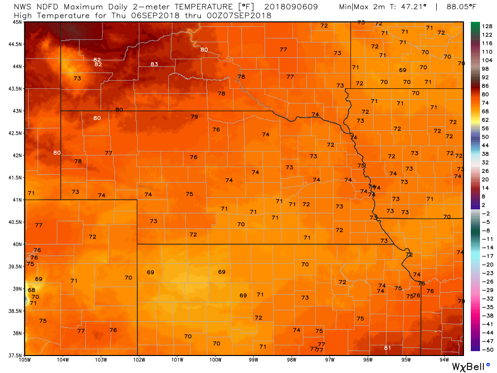
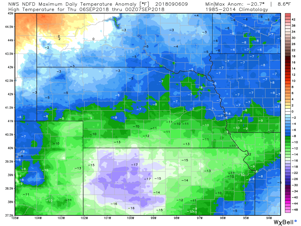
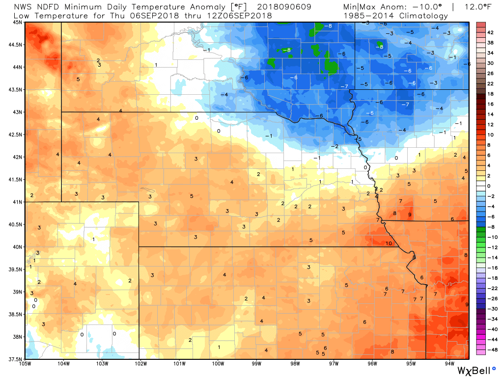
Thank you again for following! Thursday Weather Summary Nothing to talk about this morning. :-) I think the competition runs have seen the last of the rain. There could be some scattered showers south of Lincoln today, and that chance will help to keep some clouds around, but for all practical purposes, the rain is over. Temperatures will be well below normal for this time of year though, with highs running some 10 degrees or so below normal. 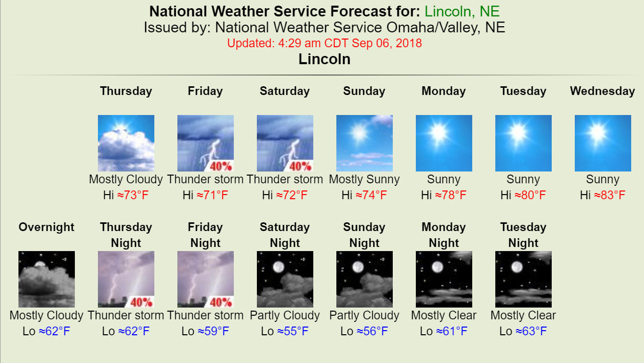 TODAY'S WEATHER MAP 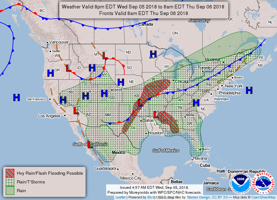 TODAY'S FORECAST TEMPERATURES
TEMPERATURE ANOMALIES
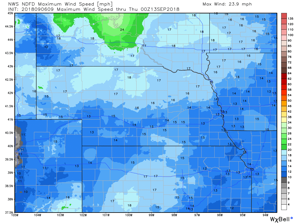
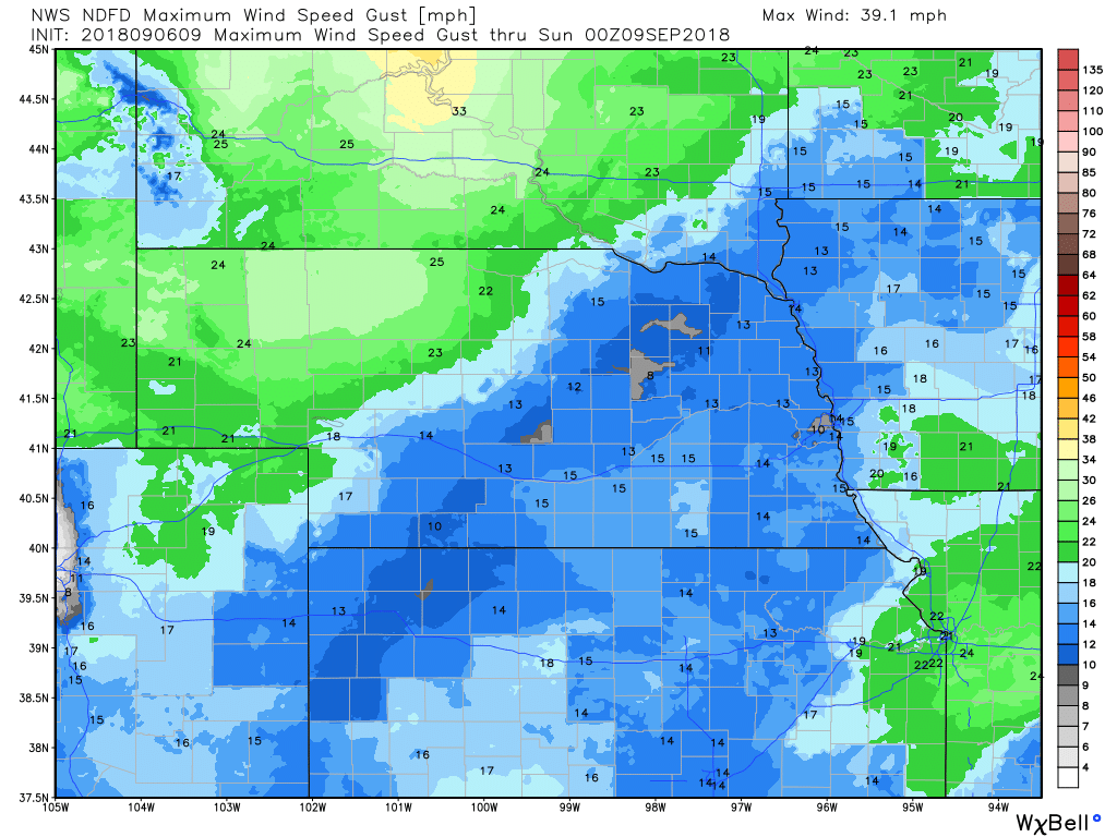
WIND
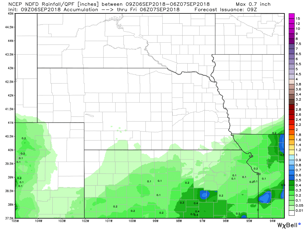
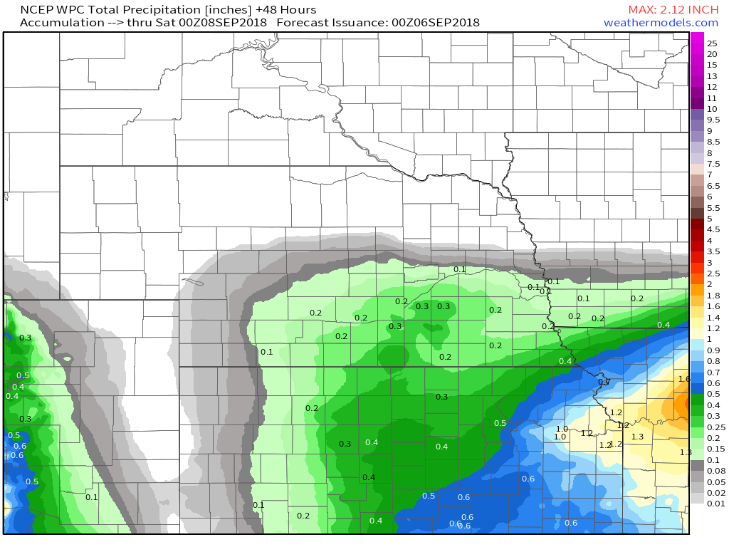
PRECIPITATION
Hour by Hour Forecast 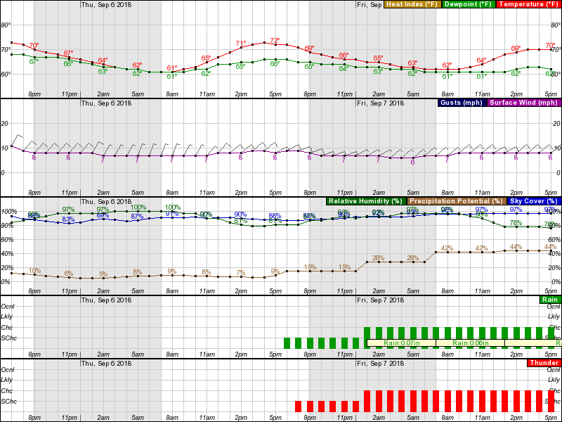 |
Archives
March 2019
Categories
All
|
OLD NORTH GA WX BLOG


 RSS Feed
|
Never base important decisions on this or any weather information obtained from the Internet. Always have a backup method of receiving weather information such as a battery powered weather radio.
Copyright © 2018 NorthGeorgiaWX.com and DaculaWeather.com 
|