Wednesday Weather Summary
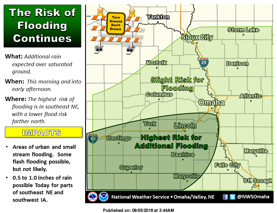
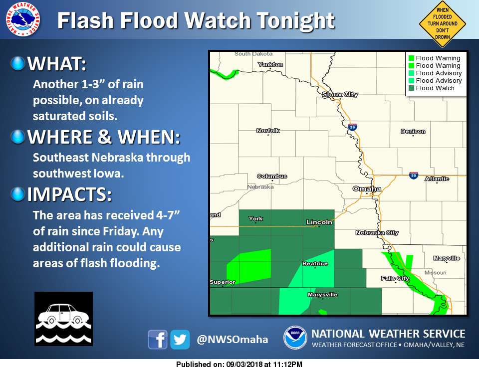
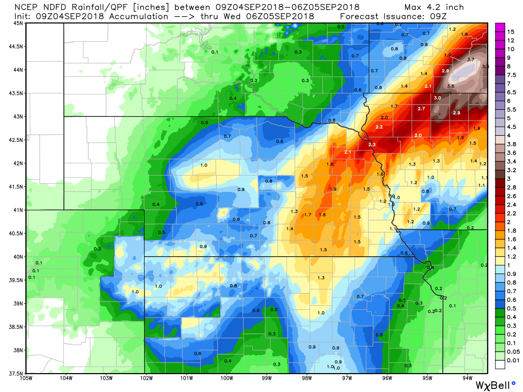
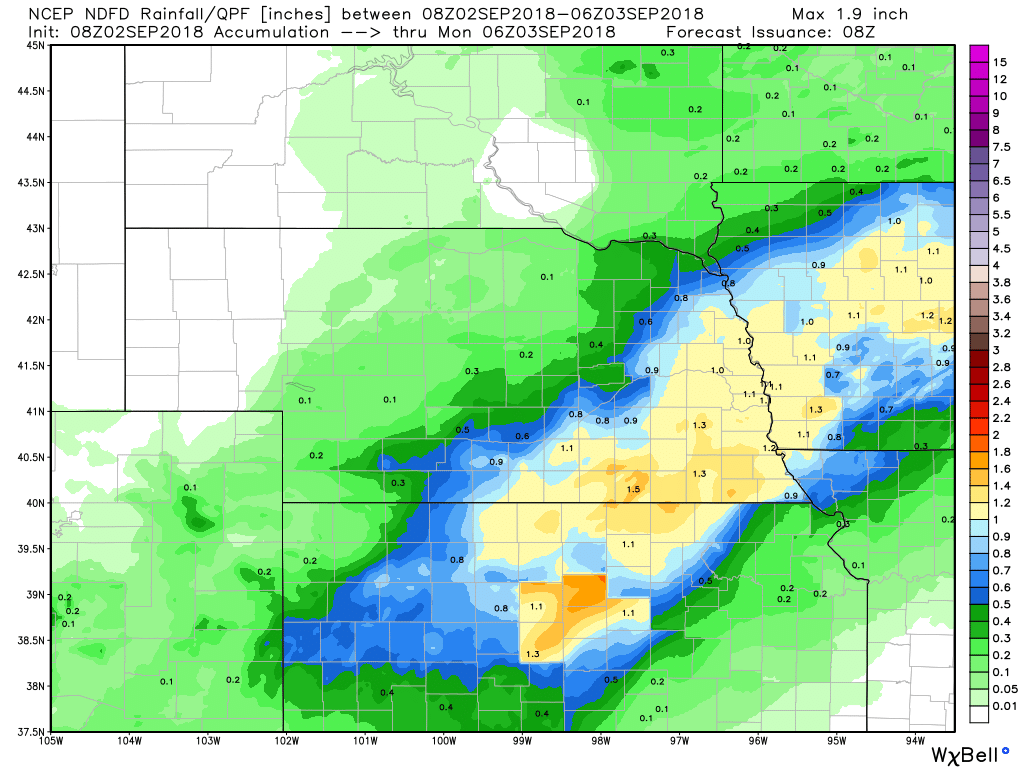
For today axis of precip is progged to shift southeast gradually through the day with progression of the cold front. At this point 3hr/6hr QPF per RAP13/HRRR/NB in agreement that accumulations will remain below latest FFG. Therefore will allow current Flash Flood Watch in effect over southeast NE to expire at 18z.
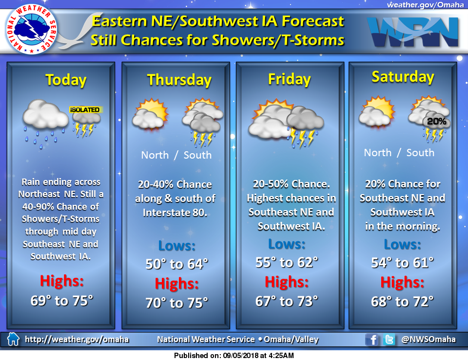
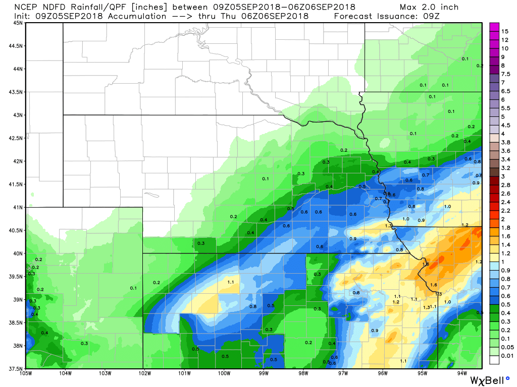
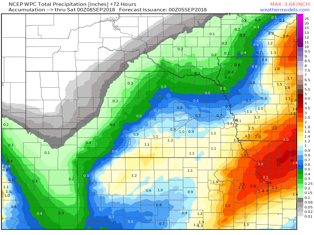
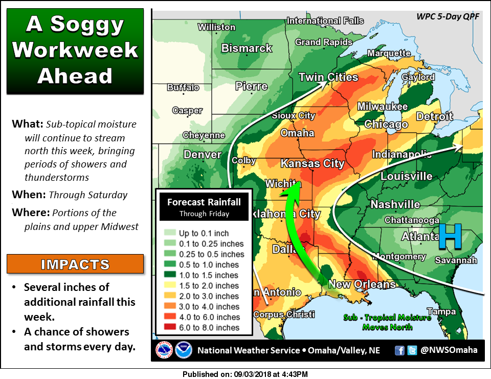
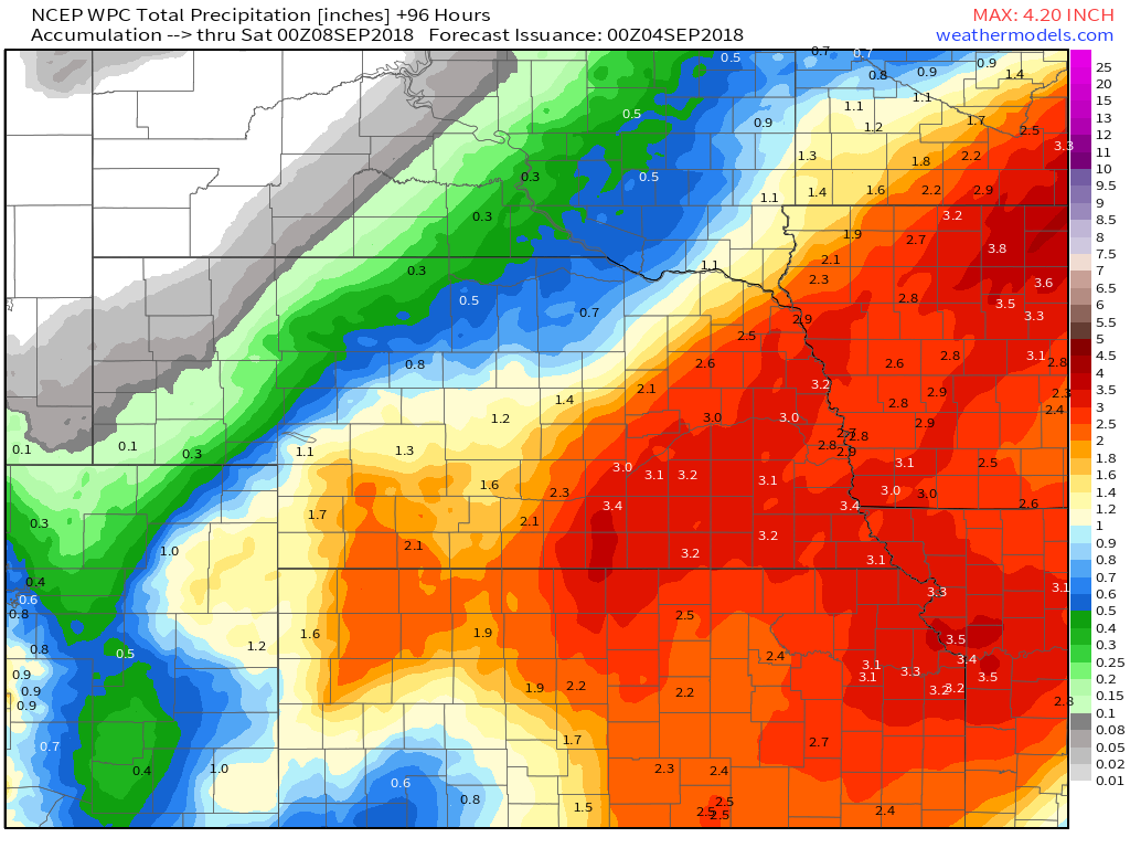
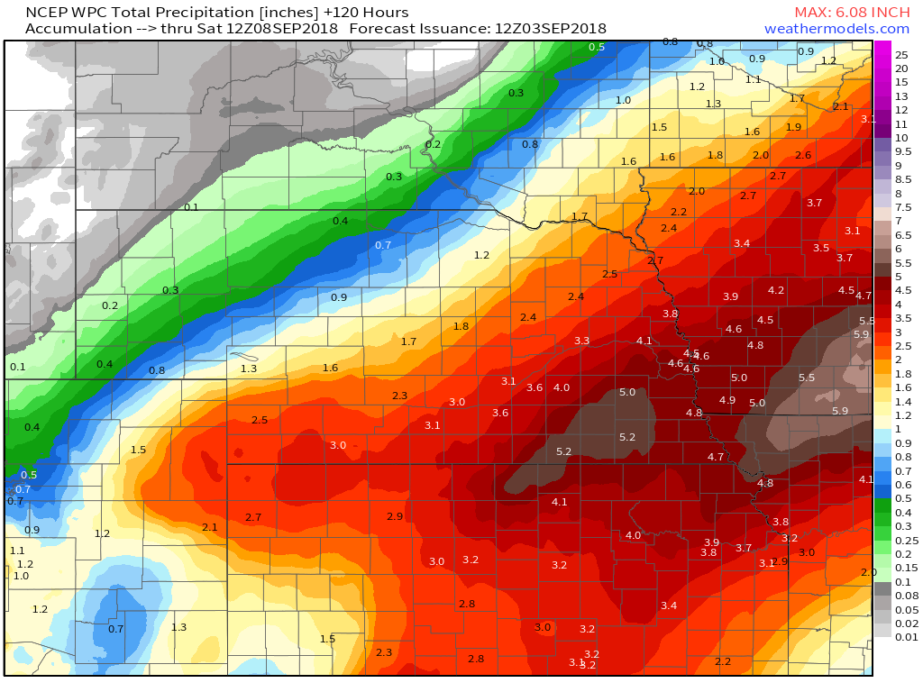
For today, Lincoln will have some overrunning showers in the area, so there is still a decent chance for rain. The rain won't be as heavy as past days and the coverage will be much less. Unfortunately, WPC as again placed portions of the southern CWA under a slight risk for excessive rainfall tonight through Thursday night where total accumulations over the last 7 days are running roughly 300-500% of normal. All this in part to the cold front progged to stall and remain in the vicinity of the NE/KS IA/MO border and act as a trigger for additional rainfall. By Thursday night the surface boundary is progged to lift slightly to the north and allow ongoing precip to expand across the rest of the CWA. The bottom line is that we are not out of the woods yet. 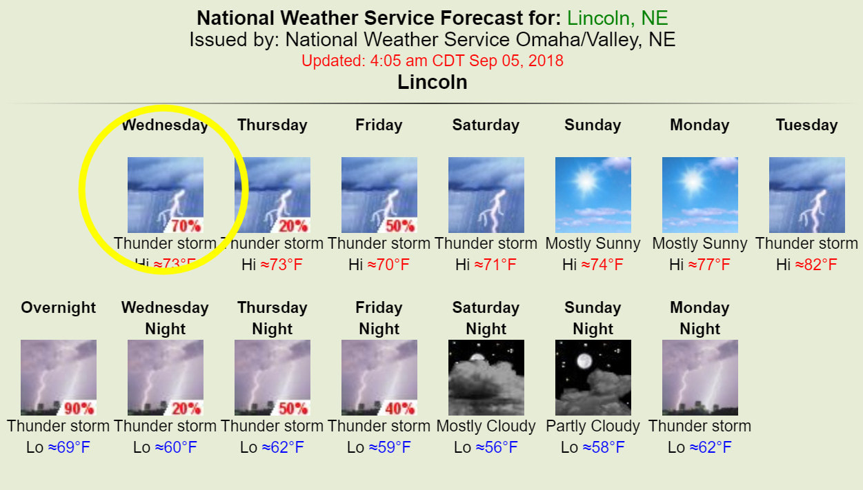
Monday/Overnight into Wednesday Radar Estimated Rainfall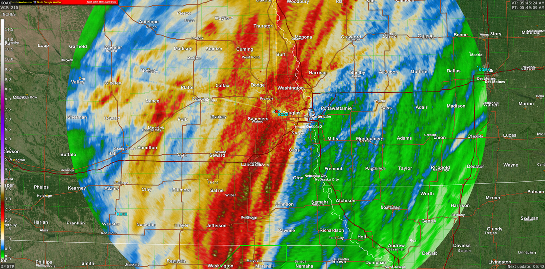
NWS Omaha Graphical Weather Outlook
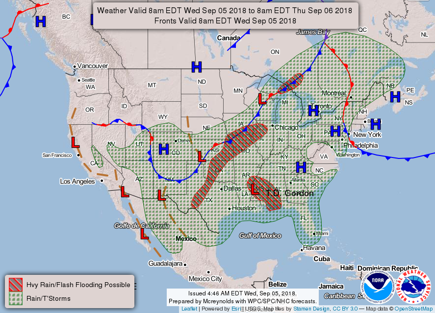
TODAY'S WEATHER MAP
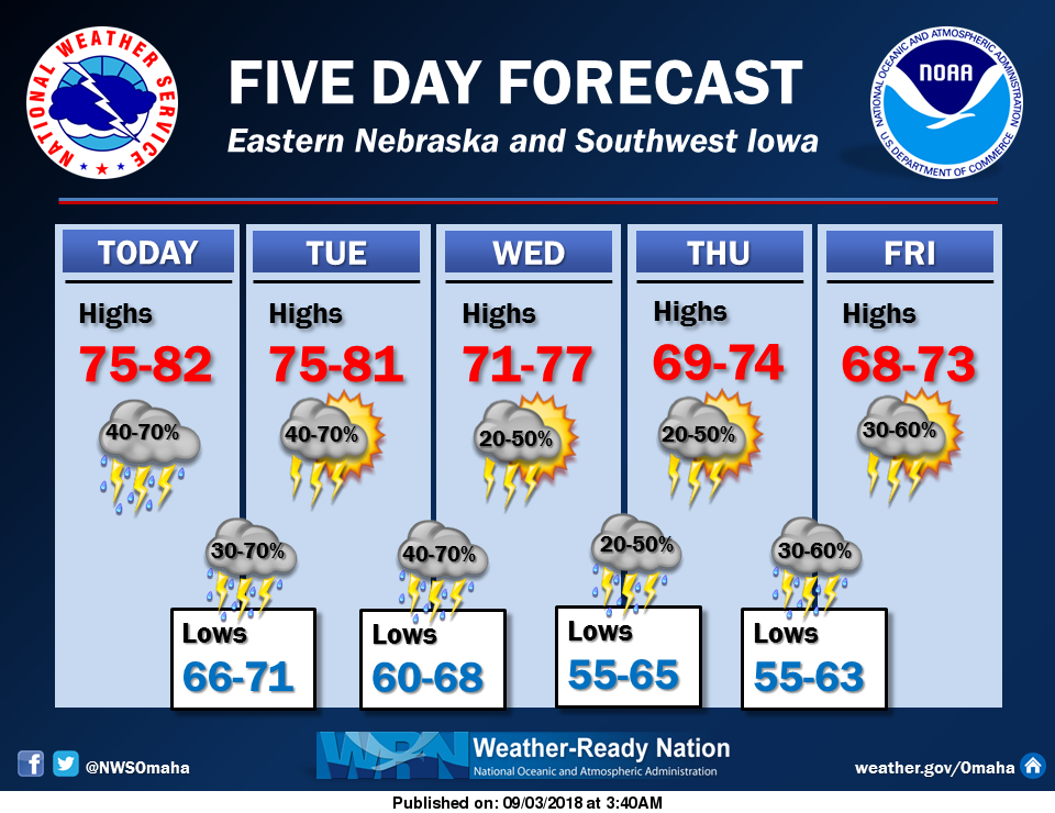
TODAY'S FORECAST
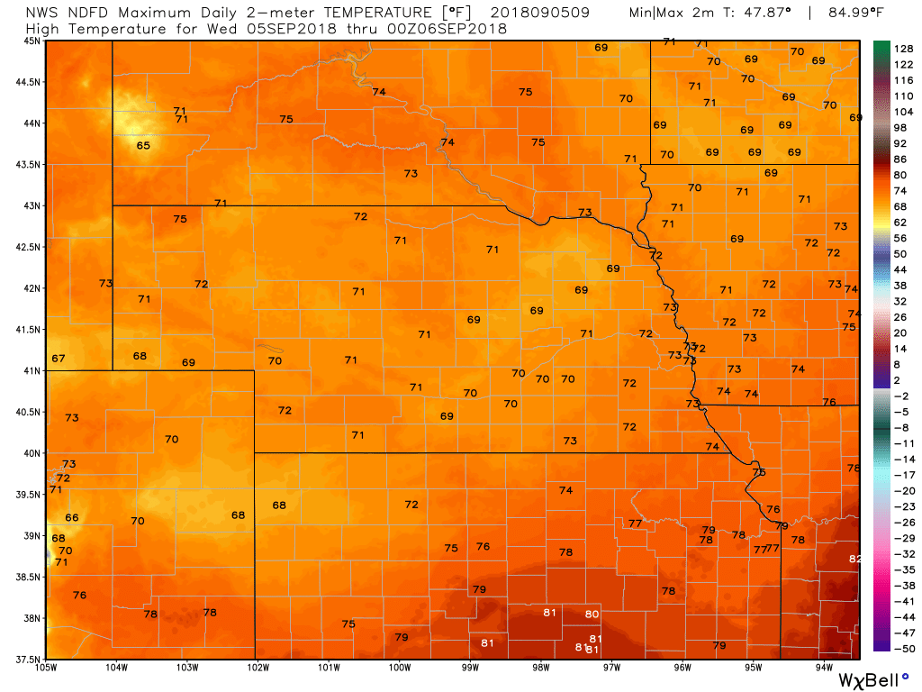
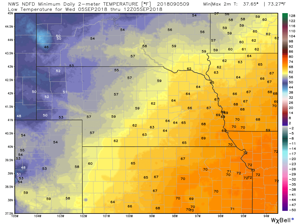
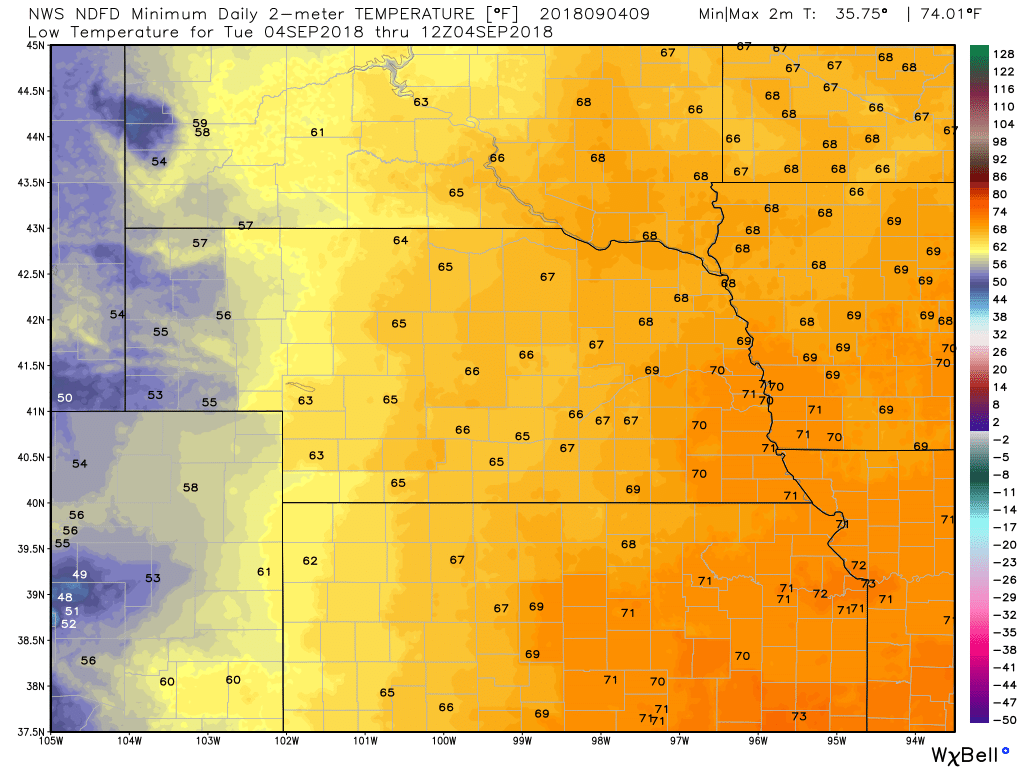
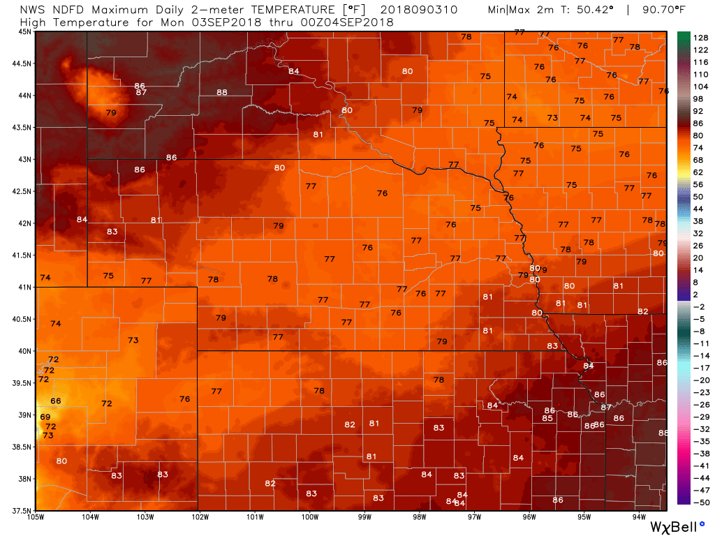
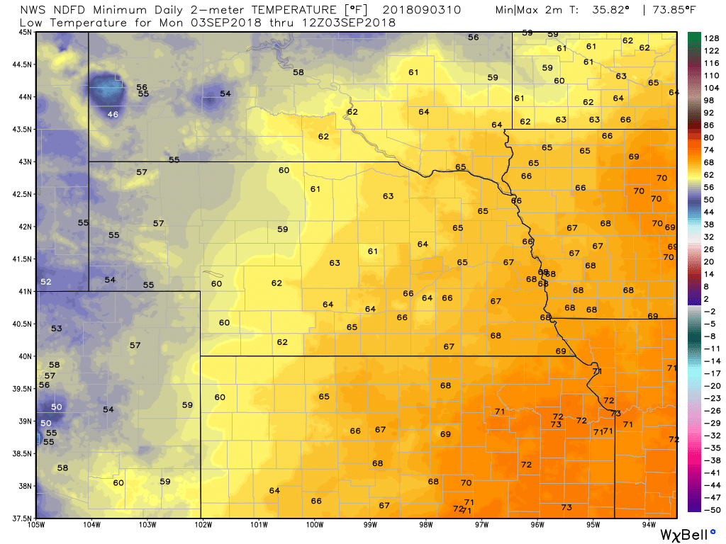
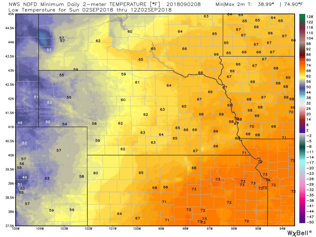
TEMPERATURES
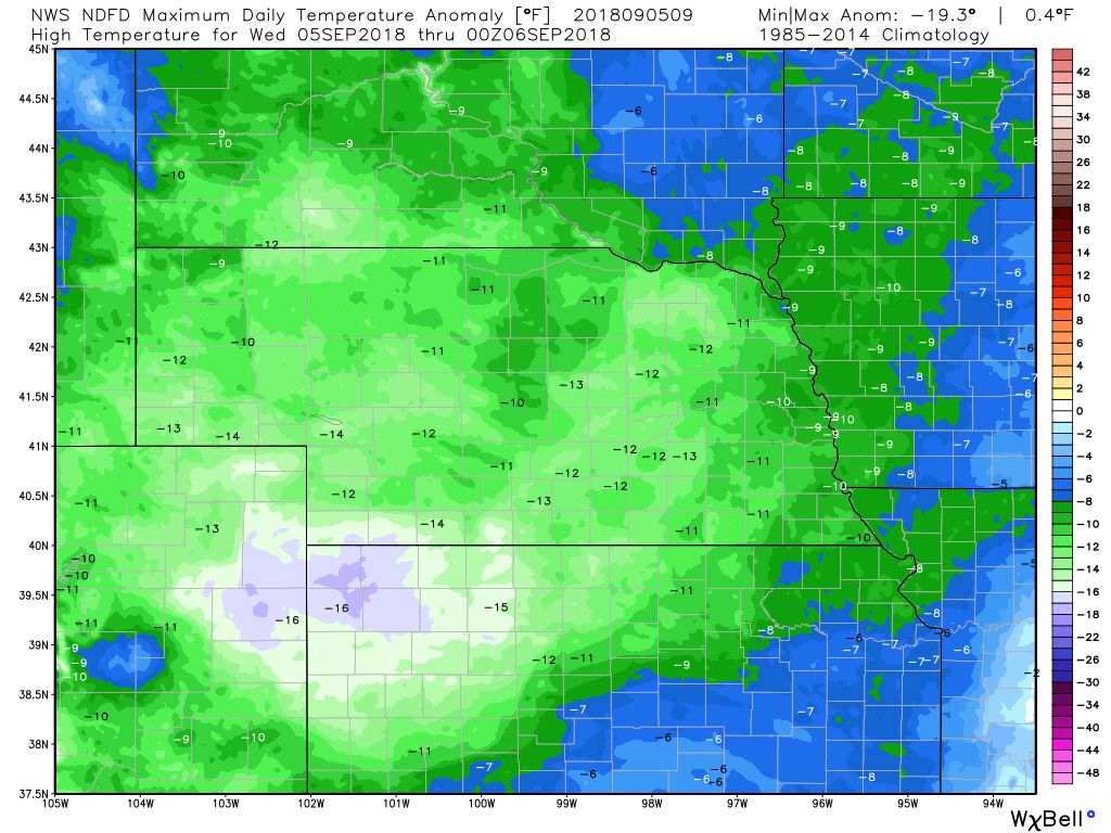
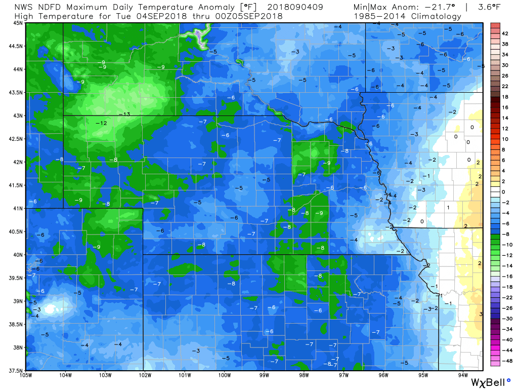
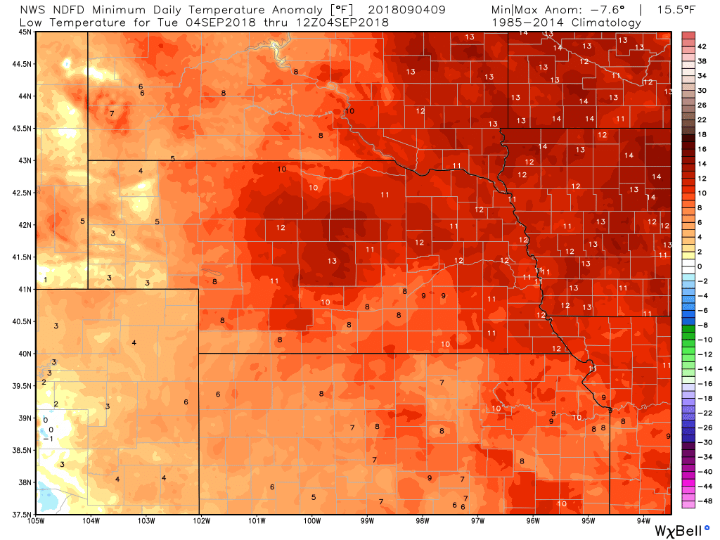
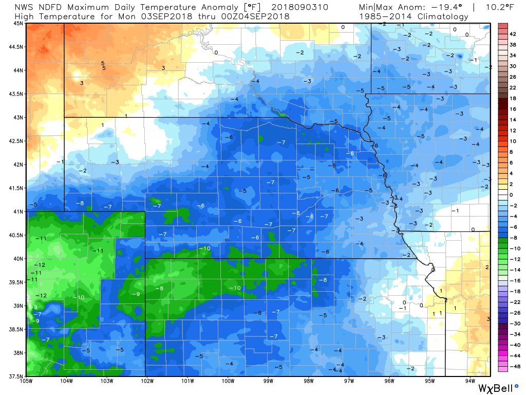
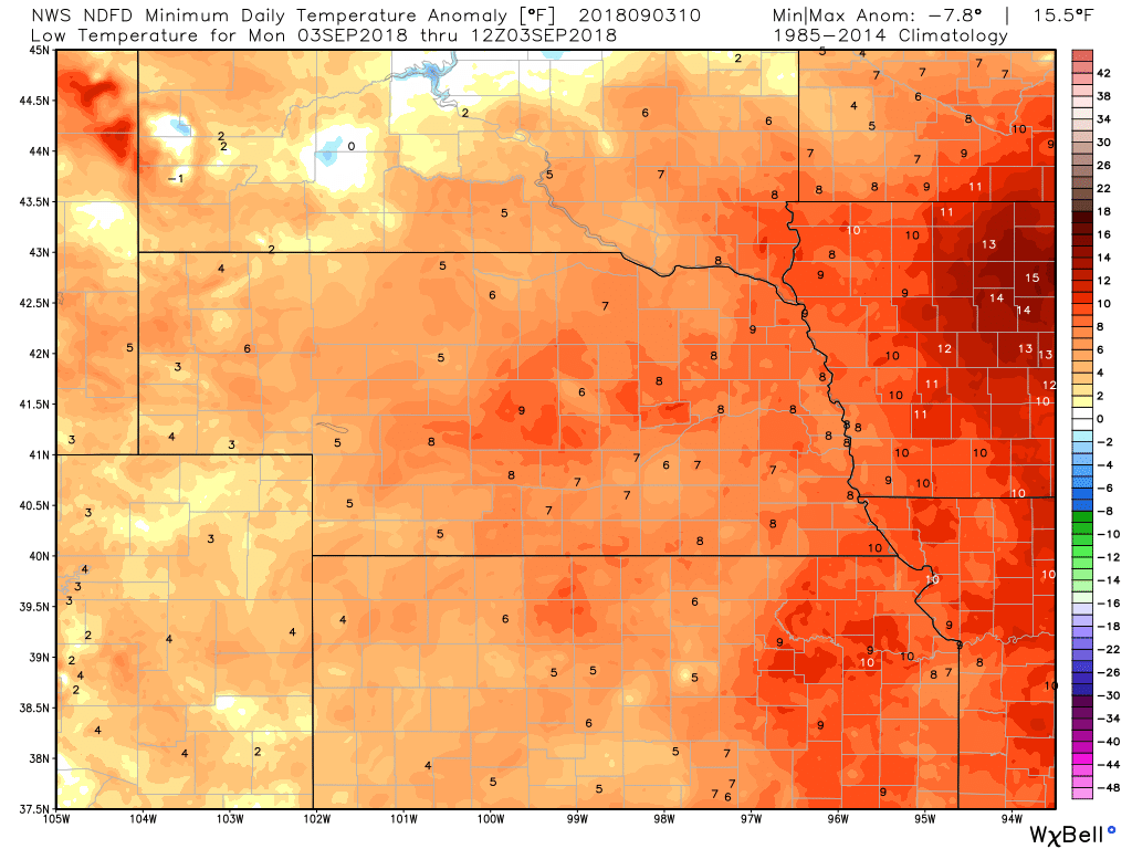
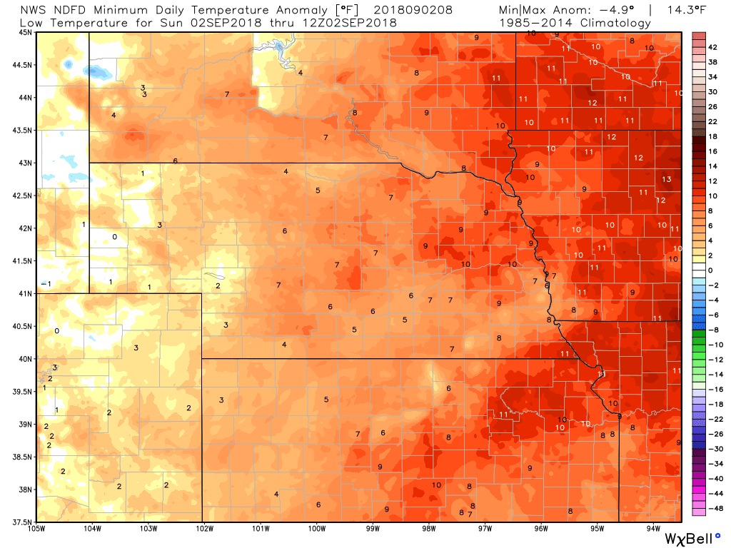
TEMPERATURE ANOMALIES
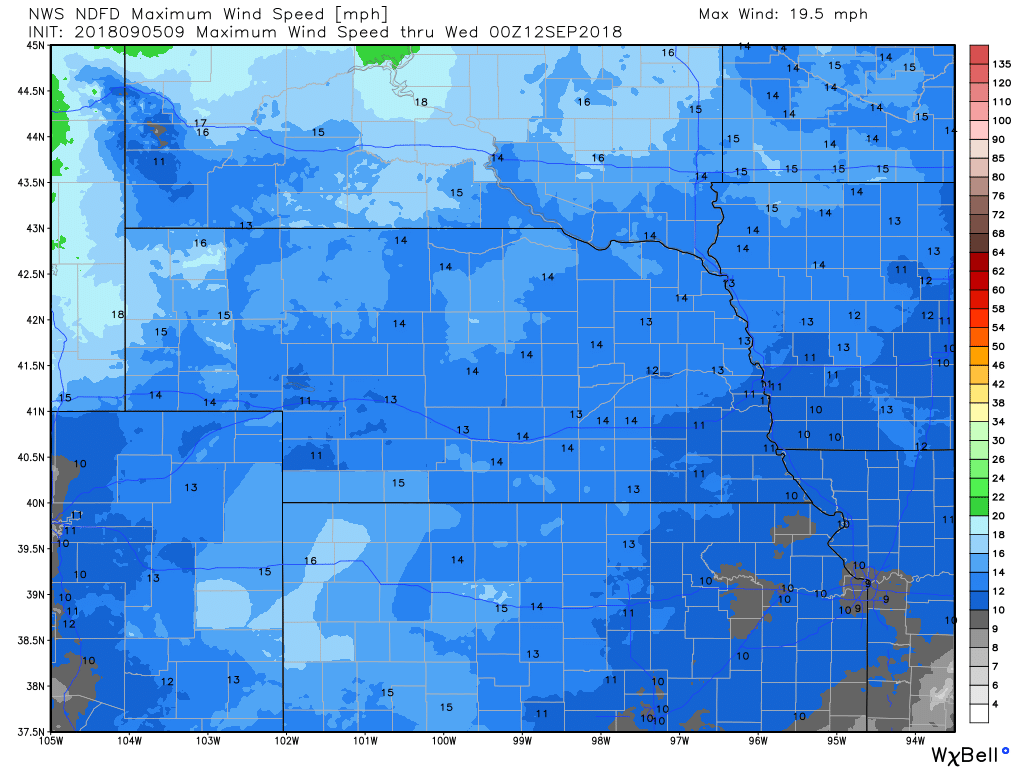
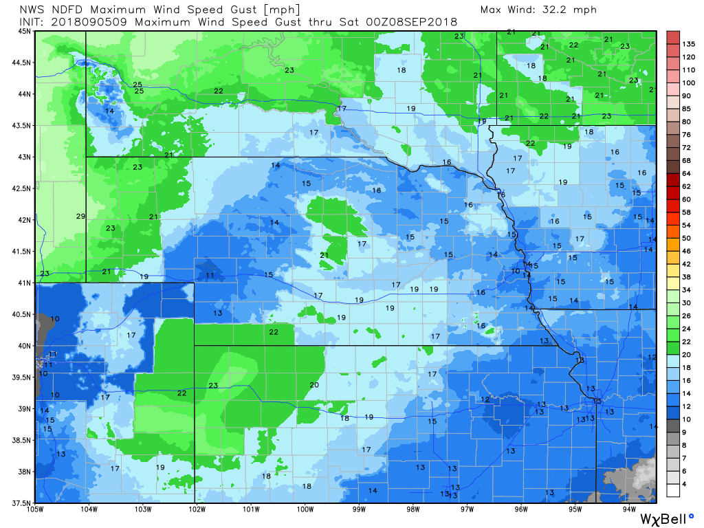
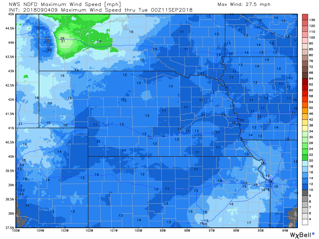
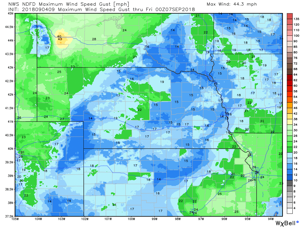
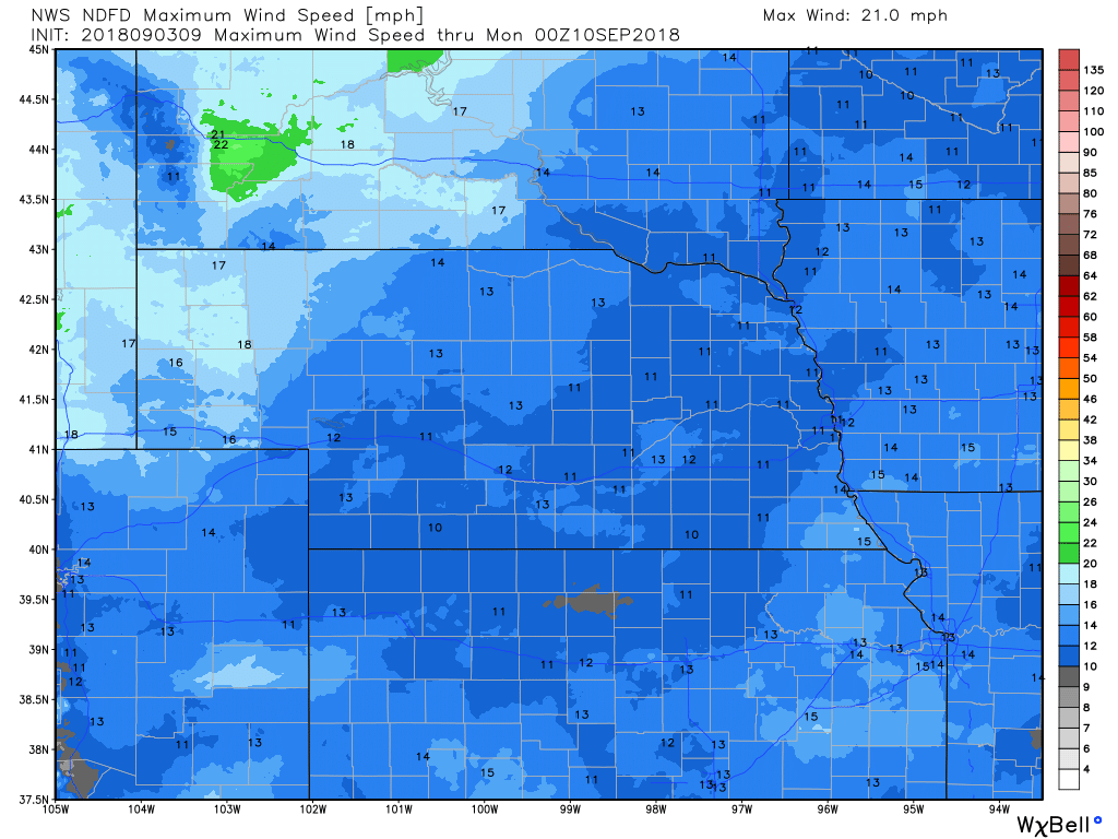
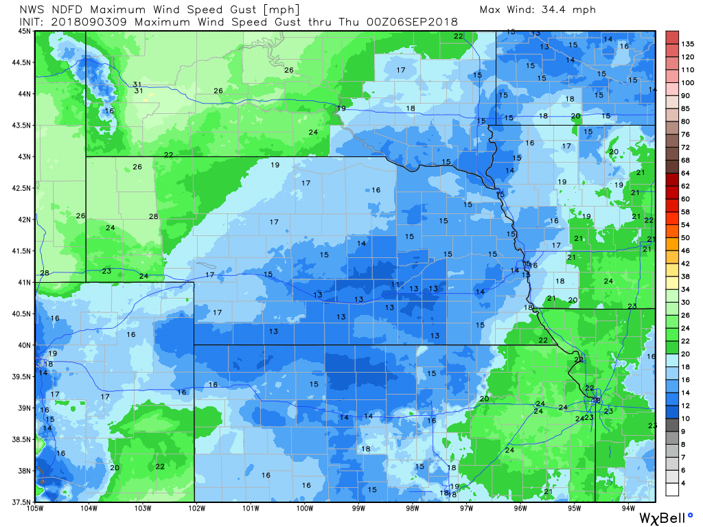
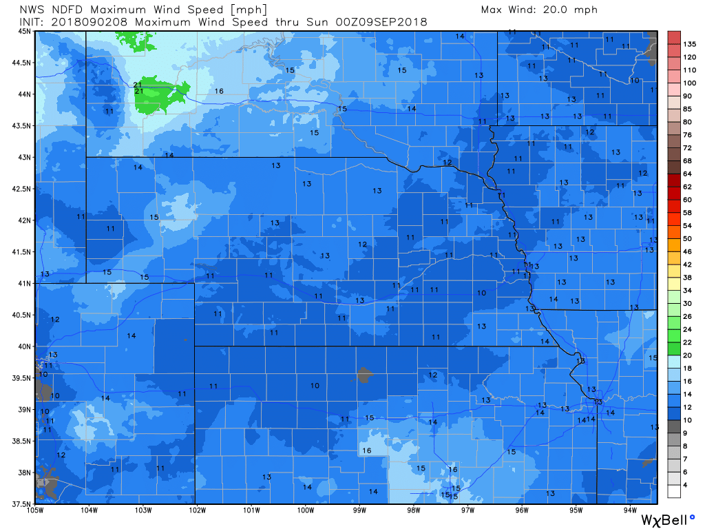
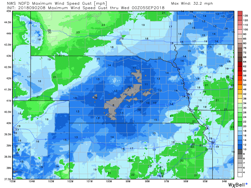
WIND
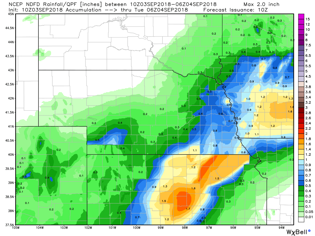
PRECIPITATION
Hour by Hour Forecast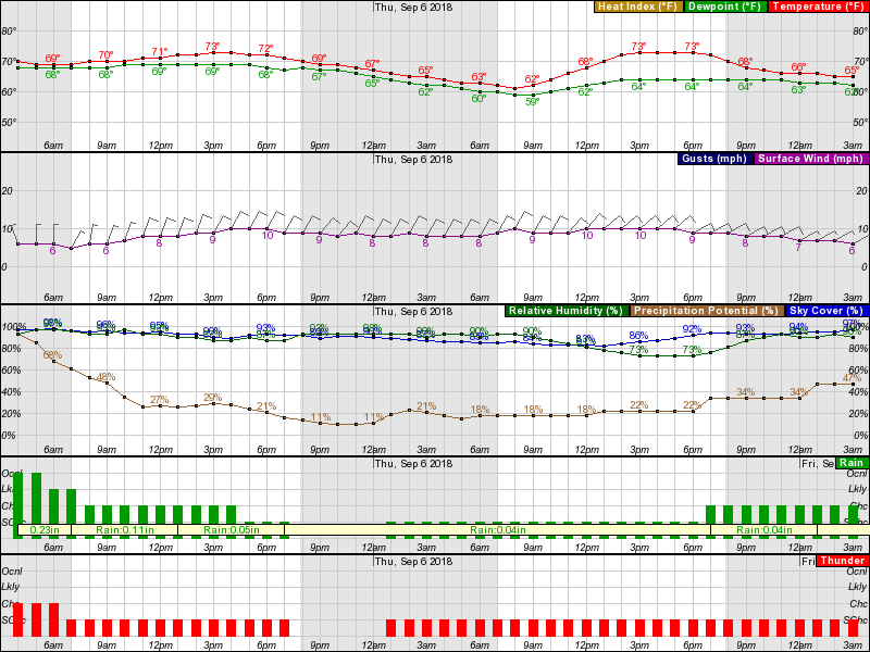
Current Radar at 5:00 am CDT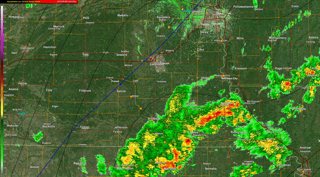
Live Radar
Tuesday Weather Summary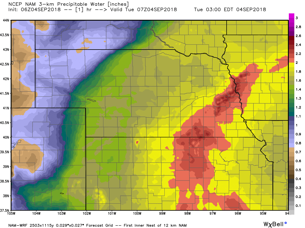 Precipitable Water Values (PWAT) Precipitable Water Values (PWAT)
WV/IR imagery this morning showing near meridional flow over the central and southern plains resulting in a northward trajectory of precip extending southward from the CWA all the way into OK. Meanwhile GOES 16 imagery was revealing the continuous influx of moisture has pushed PWAT values close to 200 percent of normal over parts of eastern KS and most of the CWA.
Unfortunately precip chances remain in play over the next couple days prompting WPC to include most of eastern Nebraska and southwest Iowa in a slight risk for excessive rainfall today through Wednesday. Models advertise near meridional flow with embedded impulses remaining in place over the central and southern plains through today. Radar mosaic the last several hours suggest area of precip currently lifting out of northeast KS will take a slight turn to the west through this morning with additional accumulation focused over areas already in a flash flood watch... Seward/Butler/Jefferson/Lancaster/Gage counties. Given this have opted to extend the watch up through early afternoon. 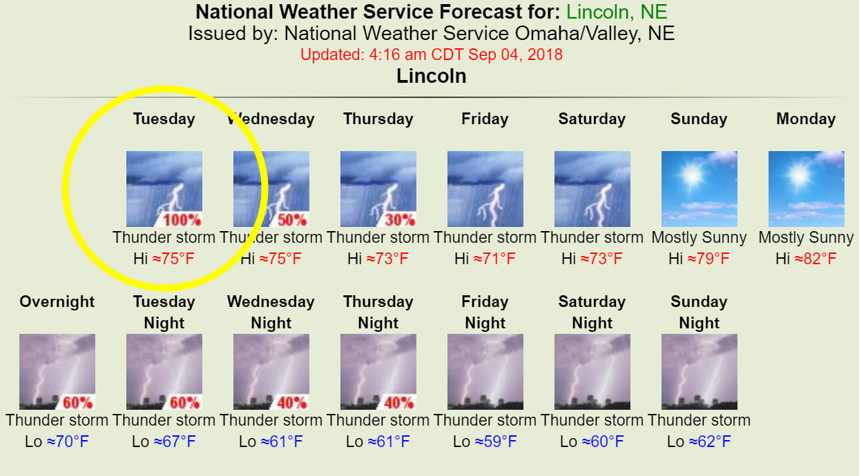
Weather Prediction Center - Excessive Rainfall Discussion WPC Day 1 Excessive Rainfall Outlook WPC Day 1 Excessive Rainfall Outlook
Another active convective day from the Plains, northeast into the MS Valley and Great Lakes region. Several well defined features at play that will likely result in a more organized flash flood threat today compared to yesterday.
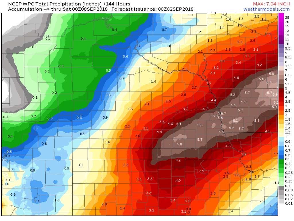
The first feature is a shortwave currently moving north across OK as of 08z. The second is a cold front moving southeast across the northern Plains this morning. Third is a strengthening upper level jet from the Dakotas into MN. The shortwave moving north across OK is forecast to maintain or even become more well defined as it shifts northward through the day. Strong 850mb moisture transport will persist ahead and east of this wave, moving into the MS Valley by this afternoon. This wave and increased moisture transport will run into the eastward moving cold front resulting in an enhanced area of lower level convergence. By this time will also begin to see interaction with the upper level jet to the north, increasing upper level divergence above the lower level convergence signature. Thus all in all should have many synoptic ingredients in place for a heavy rainfall event. The wave moving along and just ahead of the front should allow for an axis of training convection across portions of IA/MN/WI. This will all be happening within a very moist airmass with PWs forecast around 2", which is around record values for early September. Monday/Overnight Tuesday Radar Estimated Rainfall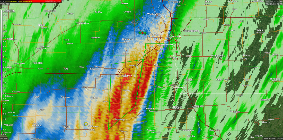
NWS Omaha Graphical Weather Outlook
TODAY'S WEATHER MAP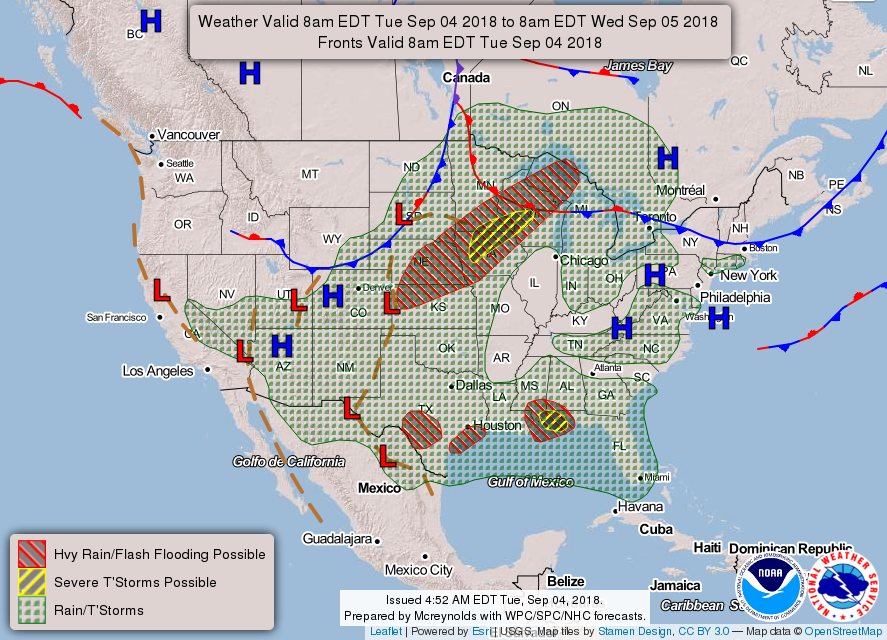
TODAY'S FORECASTTEMPERATURES
TEMPERATURE ANOMALIES
WIND
PRECIPITATION
Hour by Hour Forecast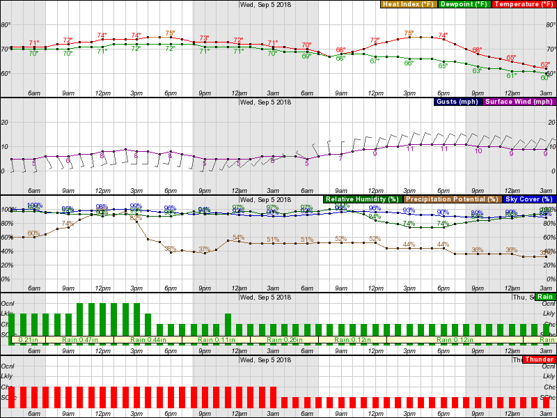
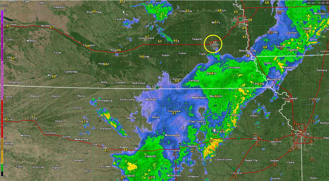
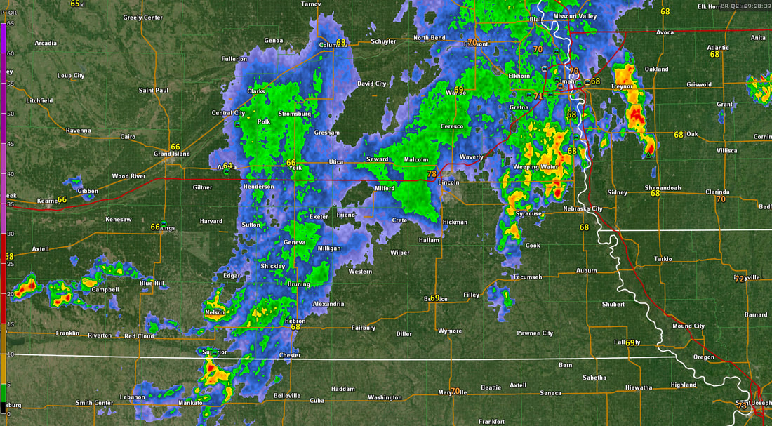
Current Radar at 4:48 am CDT
Live RadarMonday Summary
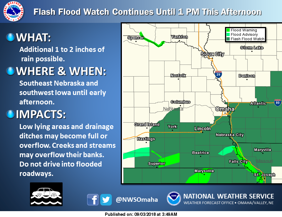
Thunderstorm chances, rain amounts and the potential for flash flooding are the main forecast concerns. Will extend the current Flash Flood Watch until 1 pm and let the day shift take a look at things. Parts of the area may need another watch for tonight into Tuesday. There could be a lull during Monday morning into early afternoon.
Thunderstorms are expected to continue across at least parts of eastern Nebraska and southwest Iowa this morning. Some storms could be strong with locally heavy rain. Additional heavy rain where the ground is already wet, could cause flooding. Thus a flash flood watch remains in effect until 1 pm today for parts of southeast Nebraska and parts of southwest Iowa. With low pressure to the west, we should generally stay in southerly low level flow until a cold front pushes across the area from the northwest late Tuesday into Tuesday night. Rain chances will remain generally high for any 12 hour period, but timing will be problematic. We could see additional heavy rain tonight, but if it does not fall where conditions are already quite wet (mainly southeast NE into parts of southwest IA) then we may be able to handle the rain. There signals that the axis of heaviest rain could shift farther to the west tonight. the axis of heaviest rain then may be shifting back to the east through the area on Tuesday. rain chances should be lower on Wednesday, especially across the northern half of the forecast area.
RECORD EVENT REPORT
NATIONAL WEATHER SERVICE OMAHA/VALLEY NE 135 AM CDT MON SEP 3 2018 ... RECORD DAILY MAXIMUM RAINFALL SET IN LINCOLN, NEBRASKA... A RECORD RAINFALL OF 2.42 INCHES WAS SET AT LINCOLN NE YESTERDAY. THIS BREAKS THE OLD RECORD OF 1.63 SET IN 1926. 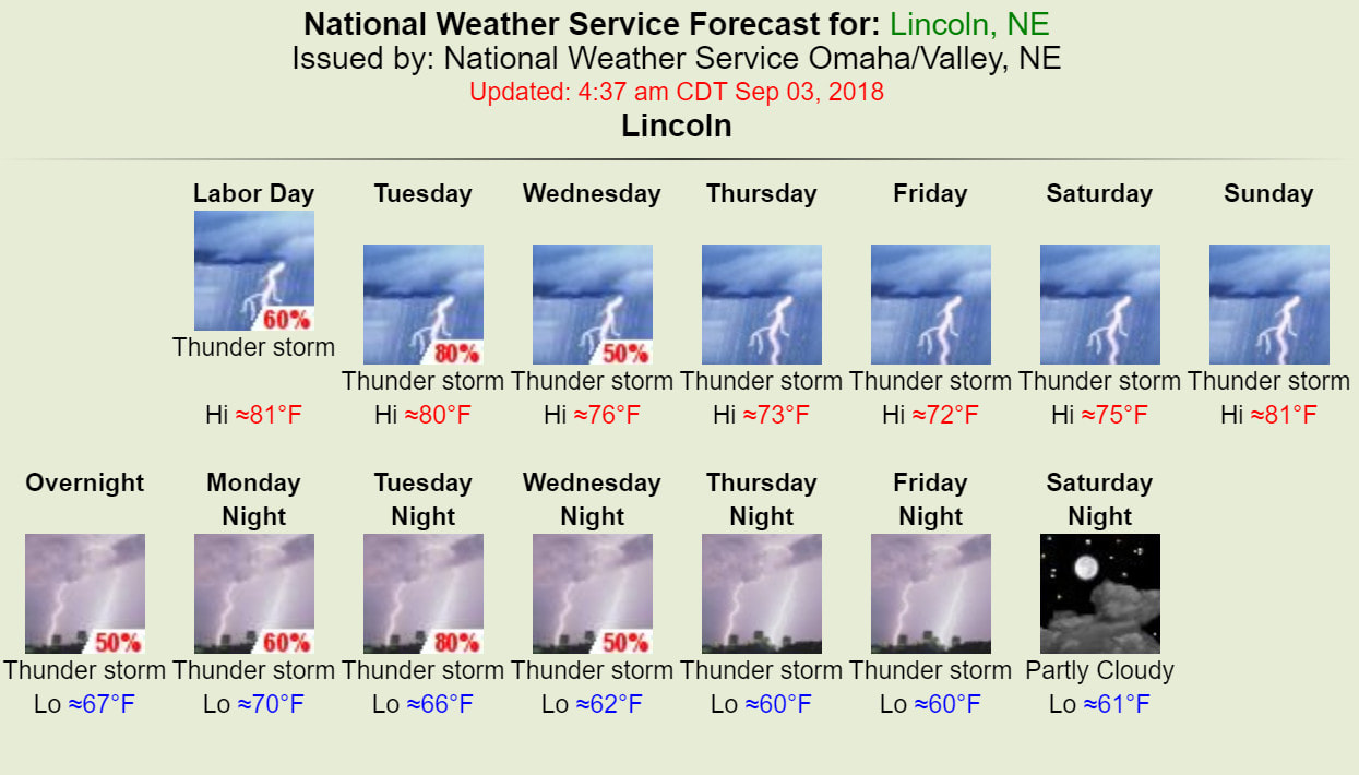
Weather Prediction Center - Excessive Rainfall Discussion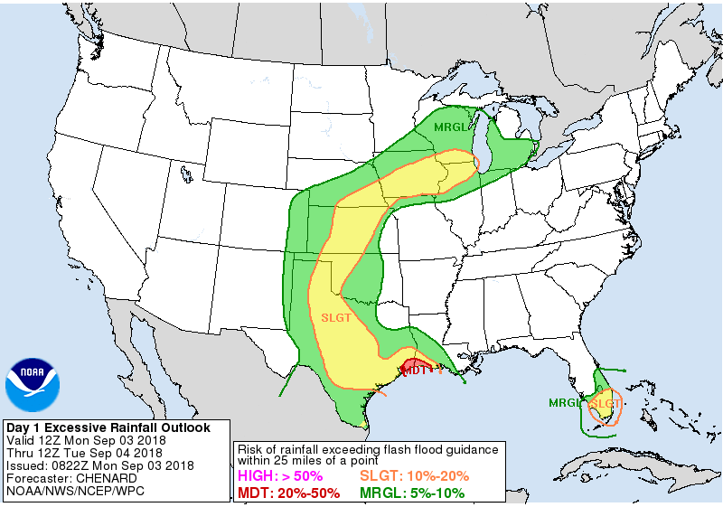 Day 1 Excessive Rainfall Outlook Day 1 Excessive Rainfall Outlook
The area remains in between troughing over the west and ridging over the east, resulting in a broadly convergent flow pattern over the region. The continued southerly flow will support PWs equal to or greater than previous days (with the 2"+ PW area gradually increasing in size)...plenty high enough for heavy
rainfall rates. The stagnate nature of the pattern will also continue to support repeat convection over similar areas... resulting in a continuing saturation of soils and flash flood potential. The setup today is a bit messy, with no strong synoptic feature to help focus an area of excessive rainfall. Thus tough to really narrow in on an area of greatest concern today... instead it appears like a large corridor will see conditions favorable for at least some flash flooding. Thus have opted to go with a large Slight Risk stretching from TX north across the Plains, and east into portions of IA/IL/WI. All in all should be a busy convective day across the central US. Possible that a Moderate Risk may be needed somewhere within the large Slight Risk, but confidence is just too low with the details at this point given the lack of a strong synoptic feature to focus the heavier rains. Forcing does begin to increase some overnight with diffluence in the upper levels and lower level moisture transport both increasing. Although by this time some questions on the degree of instability remaining over the areas where this lower and upper level forcing overlaps. Thus unclear how intense rainfall rates will be overnight. Sunday/Monday Radar Estimated Rainfall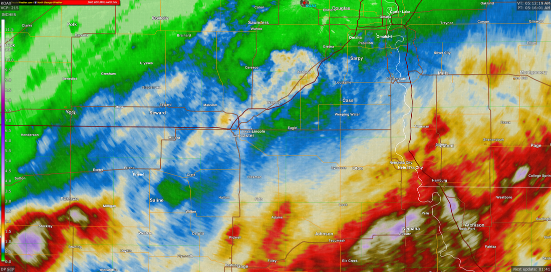
NWS Omaha Graphical Weather Outlook
TODAY'S WEATHER MAP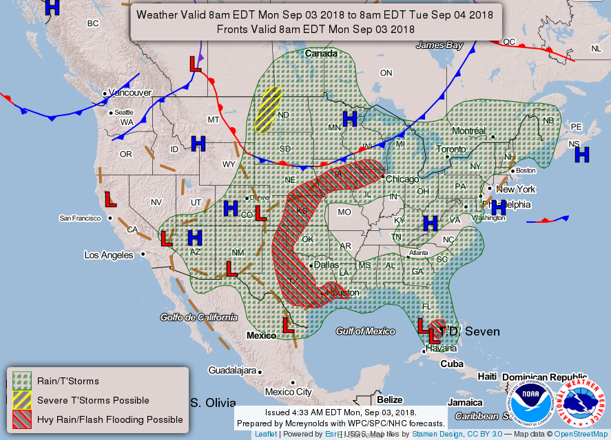
Weather at 5:18 am CDT
TODAY'S FORECASTTEMPERATURES
TEMPERATURE ANOMALIES
WIND
PRECIPITATION
Hour by Hour Forecast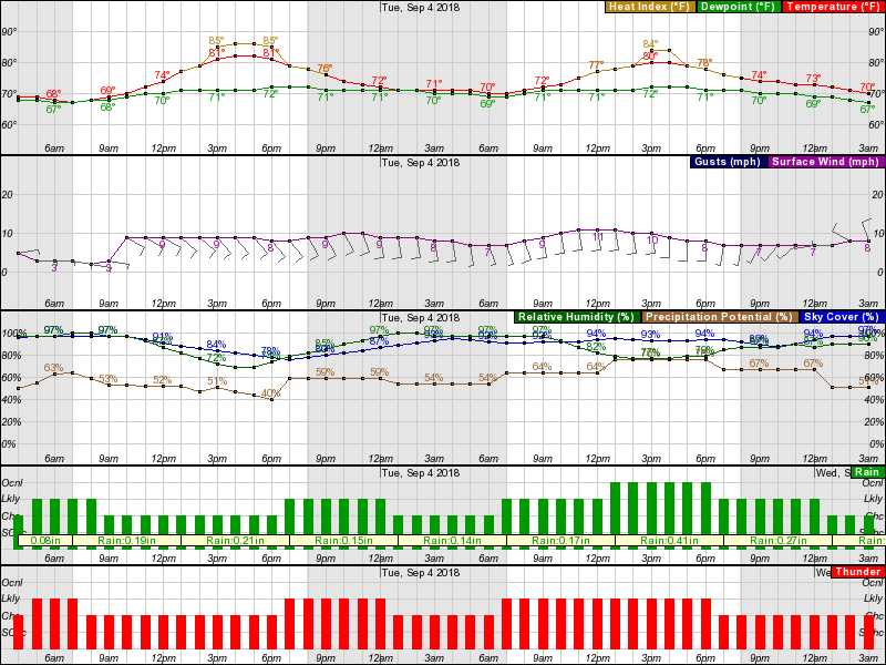
CURRENT RADARSunday Summary
Unfortunately the overall forecast will remain active through at least mid week, and it will be difficult to provide exact timing for the highest thunderstorm chances.
Scattered showers and thunderstorms remain around the Lincoln area as of 550 am Sunday morning and these will probably decrease by mid morning. Then a short break in precipitation is possible in the late morning. Unfortunately, chance for additional storms this afternoon is about 50 to 70 percent, especially late this afternoon. Chance remain high this evening. Rain that fell Saturday night has caused soil moisture to increase, so with the threat of additional heavy rain, a flash flood watch has been posted for today and tonight. This includes Lancaster County. The chance for severe storms today and this evening does not seem to be quite as high as yesterday, but some storms will be capable of producing strong winds and hail. Storm chances will continue for the next several days. We do not expect it to rain the whole time, but giving specific windows with the highest chance is difficult this far in advance. 
NWS Omaha Forecast Discussion
Thunderstorm chances/timing/rain amounts are the primary forecast problems in the short term.
Lower and mid tropospheric moisture remains high over the area with southerly flow at 850 mb and southwest flow at both 700 & 500 mb. At 300 mb, a jet max of around 70-85 knots was over MN and WI at 00Z. That put parts of our area in the right rear quadrant of the speed max, with some upper level divergence. The KOAX sounding from last evening had a precipitable water (PW) of 1.60 inches, a K index of 35, MUCAPE of about 4500 J/kg (from 970 mb) and decent lapse rates from 800 to 500 mb. The large scale pattern is not expected to change a lot over the next few days. Storms developed last evening and continued into early this morning. These did produce some heavy rain, with amounts highest from Saline county into Cass, Otoe, Mills and Fremont counties. Kept part of the area that was put in a flash flood watch yesterday, and extended it through tonight (Sunday night). Several disturbances are embedded in the southwest flow aloft, one being over western KS early this morning. That should keep some storms going for a while this morning. Confidence is not overly high on exactly how things will evolve today. The ESRL HRRR model shifts storms that are over southeast/ east central NE as of 4 am farther north, then develops some strong storm in far southeast NE and southwest IA late morning/early afternoon. There are signals for potential excessive rain, and decided to adjust the flash flood watch issued yesterday. Did not include far southeast NE at this time, since there has not been a lot of rain there lately. Will need to monitor this area however later today and tonight. Threat of severe storms for most of the area for today seems a bit lower than yesterday, but still think some severe storms could occur mainly south of Interstate 80 today/tonight where afternoon instability should be highest (CAPE possibly 3000-4000 J/kg. Confidence on severe potential for Monday and Tuesday is low. Weather Prediction Center - Excessive Rainfall Discussion Day 1 Excessive Rainfall Outlook Day 1 Excessive Rainfall Outlook
The leading edge of a broad baroclinic zone was marked by moderate to strong instability and a relative absence of inhibition from central Kansas to central Iowa and then on over to the lower Great Lakes into southern lower Michigan. An upstream shortwave trough will migrate out of western Kansas overnight, and upper difluence as well as broad low level southwesterly inflow remain favorable along the length of the baroclinic zone - to support clusters of thunderstorms producing heavy rain. Thus, WPC is maintaining a lengthy Slight Risk area for excessive rainfall. Perhaps the risk of greatest impacts from flooding would be in parts of Iowa, northern Illinois, and southern Wisconsin where Flash Flood Guidance values were very low, at only 1 inch needed in 1 hour. Some of the model solutions that looked best based on observational trends included the 18Z NAM CONUS Nest (although it was a little slow initially over KS/NE) and the 12Z WRF-ARW2. In Michigan these sources appeared displaced to the north, so we adjusted by stretching Slight Risk over through the instability axis in the southern two rows of counties, including the Detroit area. Anywhere throughout the Slight Risk area PW anomalies of 1.5 to 2.0 along with moderate CAPE should drive the potential for isolated 2"/hour rain rates wherever cell mergers or training occurs. Look for more information in mesoscale precipitation discussions.
Saturday/Sunday Radar Estimated Rainfall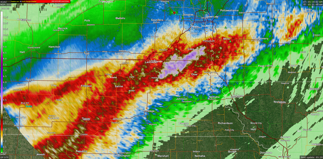
NWS Omaha Graphical Weather Outlook
TODAY'S WEATHER MAP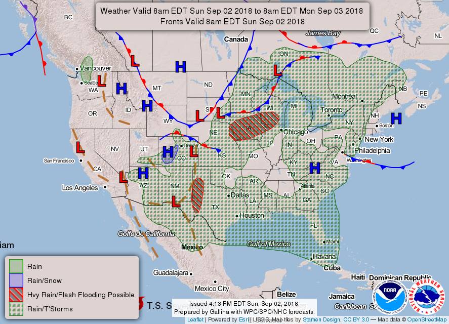
Today's Weather Map
Weather at 5:32 am EDT
TODAY'S FORECAST
TEMPERATURES
TEMPERATURE ANOMALIES
WIND
PRECIPITATION
|


NDFD - 24 Hour Precipitation Forecast
|
WPC - 6 Day Precipitation Forecast through 8 am Saturday
|
Hour by Hour Forecast

CURRENT RADAR
 RSS Feed
Archives
March 2019
October 2018
September 2018
August 2018
July 2018
May 2018
March 2018
February 2018
January 2018
December 2017
November 2017
October 2017
January 2017
October 2016
September 2016
August 2016
April 2016
February 2016
January 2016
November 2015
September 2015
June 2015
January 2015
December 2014
November 2014
October 2014
September 2014
August 2014
July 2014
June 2014
May 2014
April 2014
March 2014
Categories
All
2015 2016 Winter Forecast
2015-2016 Winter Forecast
2016
2017 Snow
2017 Winter Weather
2018-19 Weatherbell Winter Forecast
2018-19 Winter
2018-19 Winter Forecast Summary
2018 Rainfall To July
2018 Severe
AGW
Arctic
Autocross Weather
Daculaweather.com
Drought
East Based QBO
El Nino
EPO
Fall
February 2018
General Weather
Intel NUC
January 4 2017
January 8th 2018 Winter Weather
La Nina
Mobile Apps
Models
QBO
Sea Ice
Severe
Severe - 02/23/16
Severe 02/24/18
Severe Cheat Sheet
SE Winter
Spring
Stratosphere
Teleconnections
Tropical
Weather Computer
Weather Station And Computer
Winter
Winter 2017 18
Winter 2017-18
Winter 2018
