|
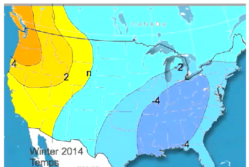
EDIT: I will be adding additional information to the bottom of this post until I do the next one around October 1. Please check back for updates, I'm sure they will be frequent! As we approach meteorological fall (September 1), I thought it would be a good time to take a long range look at our potential for winter weather for this upcoming 2014-2015 winter season. I'm ready for winter, so I had to share what we currently believe may happen. The outlook is based on the factors that are currently in place, and/or expected to be in place by the time winter arrives. Keep in mind, no one has that crystal ball that will tell us what's going to happen this winter (although if you know of one for cheap, I'm in the market... :-)), but if we take the time to look at similar weather patterns from the past, we can use those analogs to help to predict what may be in store for us in the future. One of my weather buddies is a weather statistician, particularly regarding Georgia weather. But Larry (aka "Brother Larry" if you've followed my past Patch.com blog) also keeps stats on Nina/Nino events as well as other types of weather information, and has been spot on in the past about statistically analyzing past winter weather seasons and providing probabilities for future events. Fun stuff! Larry has graciously allowed me to quote him about some of the statistical probabilities for the weather this winter in the Atlanta area, so many thanks to Larry and his hard work putting these statistics together. In Larry's post, he makes reference to several teleconnection indices as well as the ENSO status. Here are some links to those indices that will help you better understand what he's talking about. Click on a specific bullet item for further information: 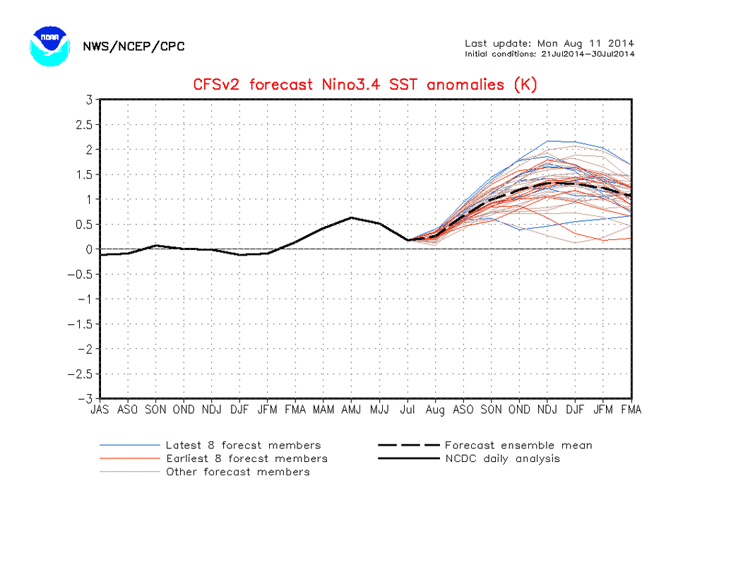 Nino3.4 Forecast 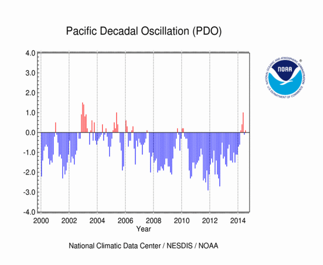 PDO (Pacific Decadal Oscillation) 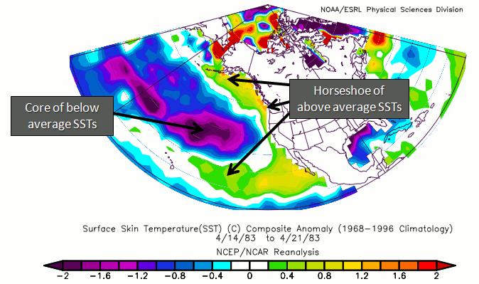 +PDO anomalies Right now, the highly touted "Super Nino" that many expected to materialize, has not happened and doesn't appear likely to happen. It now appears that a weak to neutral Nino may occur in it's place. Typically, weak El Nino's have brought great winter weather to the southeast (great meaning if you like winter weather!), and I have more on that below in Larry's post. The PDO has been in a positive phase for the first 6 months of this year, and a +PDO (plus weak Nino) is what we want for winter weather here in the southeast. Note that with a +PDO, or positive phase, the "wintertime Aleutian low is deepened and shifted southward, warm/humid air is advected along the North American west coast and temperatures are higher than usual from the Pacific Northwest to Alaska but below normal in Mexico and the Southeastern United States. Winter precipitations are higher than usual in the Alaska Coast Range, Mexico and the Southwestern United States but reduced over Canada, Eastern Siberia and Australia". Keep in mind that a strong Nino would reduce precipitation here, but a weak one actually increase our chances for winter weather. Keep these facts in mind as you read Larry's post. Larry's Winter Weather Statistics for Atlanta...In his free video from this weekend (click on the link below), Joe Bastardi shows a map with a prediction from WeatherBell.com of a very cold Southeast winter. He has much of the SE US near or even colder than 4 F below normal. In all of the years of following JB, I can't recall a forecast quite that cold for the SE. However, IF there really ends up being a weak Nino fall/winter peak, a +PDO, and a -NAO, I could see this or even colder than this actually happen. Perhaps he is already thinking somewhat along those lines.
You can see from Larry's post, it's not any one factor that determines what the winter is going to be like, it's the interaction between all of the different teleconnections (and a little luck) that determines what happens. So for now, it looks like a possibility of below normal winter temperatures with normal to above normal winter precipitation for the Atlanta metro area. All of this is dependent on the strength of the Nino during the fall and winter season, so as we get closer to winter, I'll have several additional blog post about how all of this is playing out. Look for another one around October 1 and again right around November 1. ----------------------------- UPDATE - 08/17/14
|
Archives
March 2019
Categories
All
|
OLD NORTH GA WX BLOG
 RSS Feed
|
Never base important decisions on this or any weather information obtained from the Internet. Always have a backup method of receiving weather information such as a battery powered weather radio.
Copyright © 2018 NorthGeorgiaWX.com and DaculaWeather.com 
|