|
Well, I'm not very confident about the placement of the bullseye of rain by the GFS, but someone is going to get a lot of rain this weekend as an area of low pressure forms and tracks across the Gulf coast. It appears now that the bulk of rain heavier will stay south of I-20, but everyone in Georgia may see some rain before it's all over. Most of this begins later Saturday, so if you have yard work to do, get out early if possible. We'll start with the latest Area Forecast Discussion by the Atlanta National Weather Service Office. I bolded a few sections that I thought were important. .LONG TERM /SATURDAY NIGHT THROUGH THURSDAY/... MODELS SHOW VARIOUS LEVELS OF INTERACTION BETWEEN THE SHORTWAVE TROUGH OVER THE MIDWEST AND THE SHORTWAVE TROUGH OVER TEXAS DURING DAYS 2 AND 3. THE MAJORITY OF SOLUTIONS AGREE ON 2 DISTINCT AREAS OF RAINFALL... ONE OVER THE NORTHERN GULF COAST STATES... AND ANOTHER AREA ALONG THE CENTRAL GULF COAST PERHAPS EVEN OFFSHORE. Listening to them, they favor more coastal to offshore development. The GFS paints the bullseye somewhere toward central Georgia as you can see in this image. 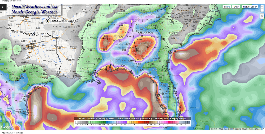
Total Precip through 2pm Monday
The WPC has their own thoughts about this system as you can see in this image: 
WPC 5 day precip forecast
There will be some very high precipitable water values this weekend, upwards of 2.2". Notice how the NW corner of Georgia is missing out. 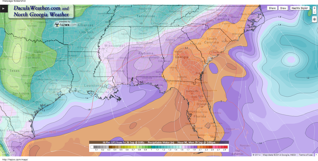
Precipitable Water Values
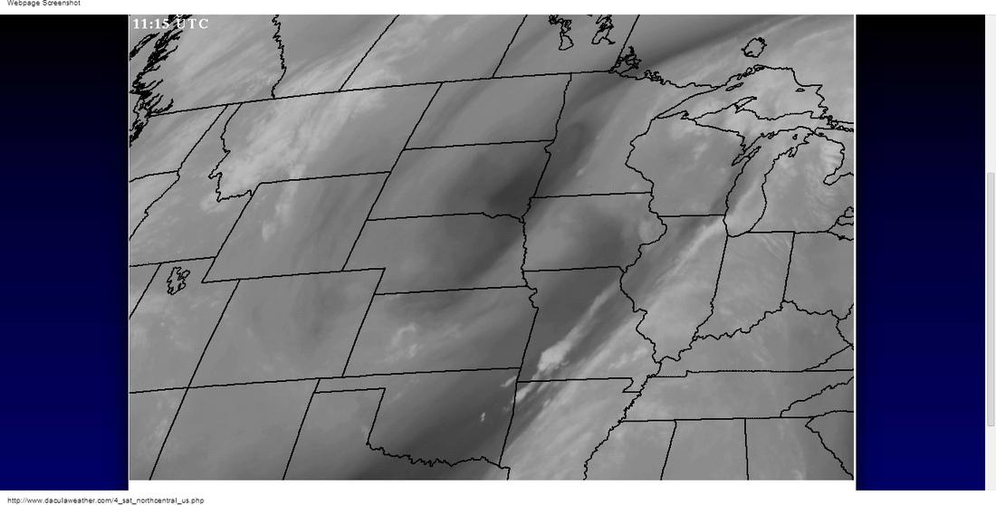
Update: Saturday 6:35am
EARLY IN THE PERIOD...
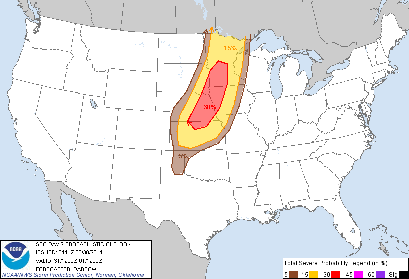
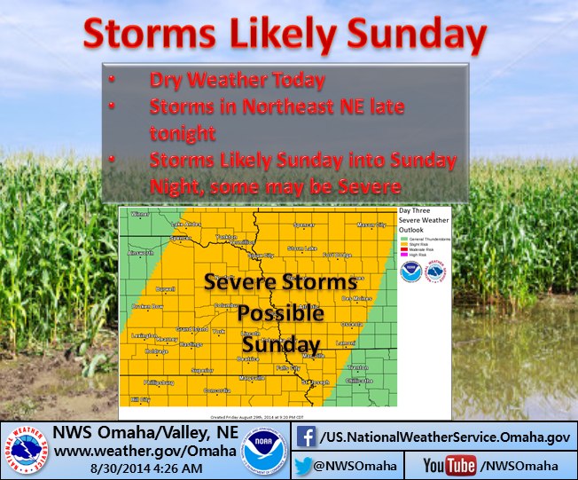
THE MAIN SHOW WILL PROBABLY WAIT UNTIL LATE AFTERNOON OR EARLY EVENING AND BE MORE TIED TO LOW LEVEL CONVERGENCE ALONG THE APPROACHING COLD FRONT. AGREE WITH SPC DAY 2 OTLK WHICH HAS ALL OF OUR AREA IN A SLGT RISK. The first two images show the bulk shear and MLCAPE parameters that they refer to in their discussion. The last image is a Supercell Composite parameter which factors in a combination of other severe weather parameters. Looks pretty ugly over Lincoln. 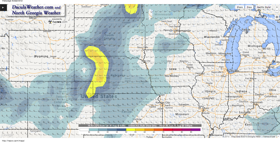 0-6 km Shear - Shear is the change in wind direction with height. 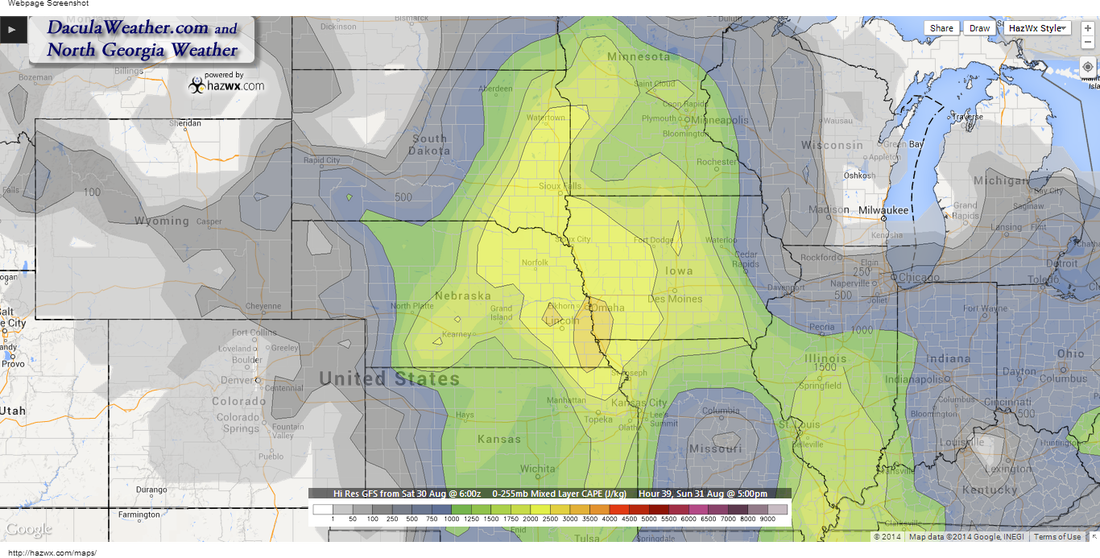 Convective Available Potential Energy. A measure of the amount of energy available for convection. CAPE is directly related to the maximum potential vertical speed within an updraft; thus, higher values indicate greater potential for severe weather. Observed values in thunderstorm environments often may exceed 1000 joules per kilogram (J/kg), and in extreme cases may exceed 5000 J/kg. Mean Layer CAPE - CAPE calculated using a parcel consisting of Mean Layer values of temperature and moisture from the lowest 100 mb above ground level. 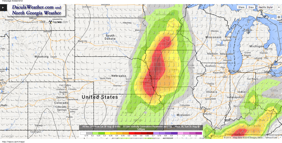 SBCAPE (Surface-Based Convective Available Potential Energy) is a measure of instability in the troposphere. This value represents the total amount of potential energy available to a parcel of air originating at the surface and being lifted to its level of free convection (LFC). No parcel entrainment is considered. The CAPE and CIN calculations use the virtual temperature correction. 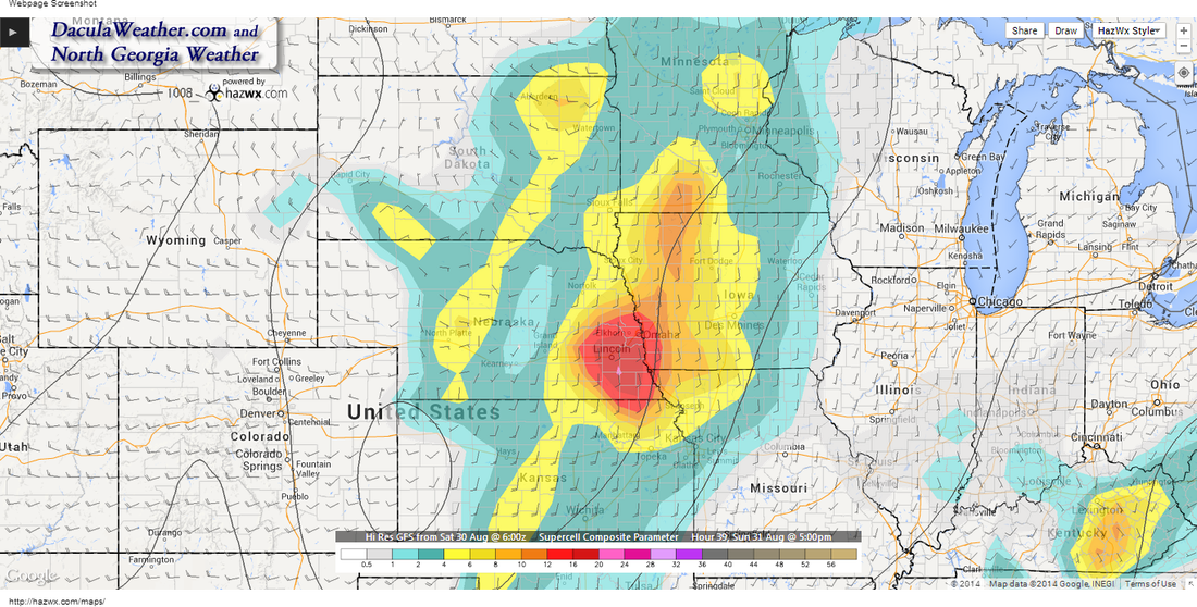 A multiple ingredient, composite index that includes effective storm-relative helicity (ESRH, based on Bunkers right supercell motion), most unstable parcel CAPE (muCAPE), and effective bulk wind difference (EBWD). Each ingredient is normalized to supercell "threshold" values, and larger values of SCP denote greater "overlap" in the three supercell ingredients. Only positive values of SCP are displayed, which correspond to environments favoring right-moving (cyclonic) supercells. Update: Friday 6:03pmHere is an update to the Sunday forecast. Most storms should be later in the day. The image below shows the Lincoln area in a Slight Risk area according to the Storm Prediction Center. Click that link for the full 3 day outlook from the SPC. ALTHOUGH ELEVATED CONVECTION COULD PERSIST INTO SUN AFTN AIDED BY LOW LEVEL JET...PER NAM/GFS...12Z ECMWF GENERALLY KEPT AREA DRY UNTIL 00Z MONDAY WHEN STRONG UPPER JET PUNCHES INTO REGION ON SOUTH SIDE OF THIS NEXT UPPER TROUGH. DUE TO UNCERTAINTY IN AMOUNT OF ELEVATED CONVECTION PRECEDING MAIN LATE AFTN/EVENING DEVELOPMENT LEFT IN MORNING POPS NW 2/3RDS AND DID NOT BREAK UP THE AFTN PERIOD TO ACCOUNT FOR POSSIBLE HIGHER CHANCES LATE IN THE AFTN. DID BOOST MAX TEMPS A FEW DEGREES SOUTH ON SUNDAY AS THAT AREA DID SEEM THE LESS SUSCEPTIBLE TO IMPACT OF MORNING WARM ADVECTION CLOUDS PSBL PRECIP. STRONG/SEVERE STORM CHANCES APPEAR HIGHER THAN PAST SEVERAL DAYS AS 0-6KM SHEAR IS STRONGER AND MAX TEMPS NEARING 90 SHOULD INCREASE MLCAPE VALUES. ALTHOUGH HEAVY RAIN WILL LIKELY OCCUR WITH THE ACTIVITY AS WELL...VERY HARD TO PIN DOWN WHERE AXIS OF HEAVIEST WILL OCCUR AS A CASE COULD BE MADE FOR IT SETTING UP JUST ABOUT ANYWHERE IN OR EVEN POSSIBLY JUST OUTSIDE THE FA. 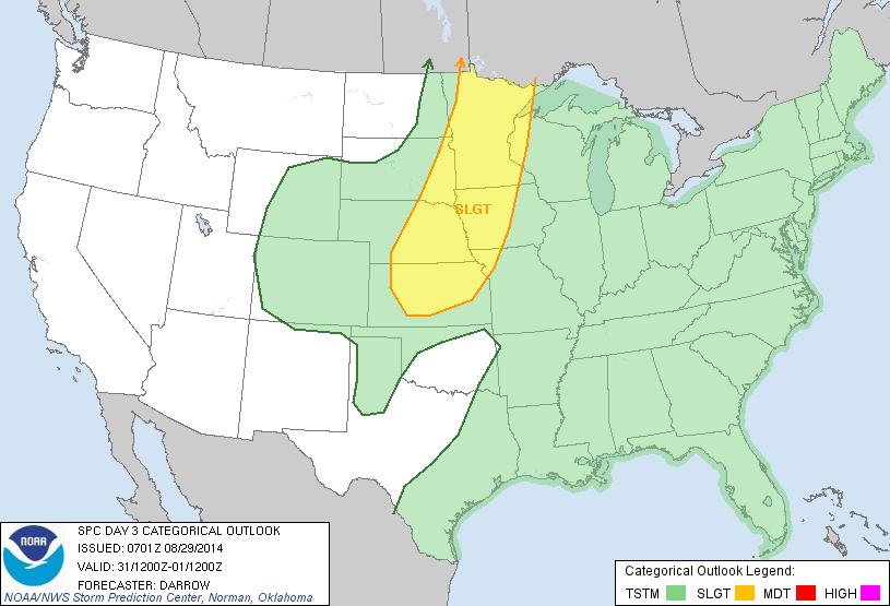 Previous PostBeginning to become a little more concerned about instability during the day and afternoon on Sunday as a shortwave rotates through the base of the trough. It now appears that there will be the possibility for some thunderstorms to popup. The majority of the bad weather should remain to the east and north, but the severe parameters are worth noting. Here is an except from this mornings AFD from Omaha NWS. I bolded the important part. .LONG TERM...(SATURDAY NIGHT THROUGH WEDNESDAY) Even more important, this from the Storm Prediction Center this morning in their 4-8 day outlook: BOTH MODELS DEPICT THE ADVANCE OF A FAIRLY STRONG UPPER TROUGH INTO THE CENTRAL U.S. DAY 4 /SUN 8-31/...ALONG WITH AN ASSOCIATED/SHARP COLD FRONTAL PROGRESSION. 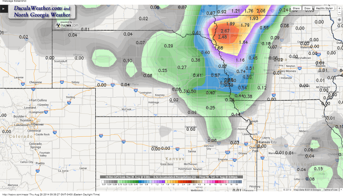 This is a 6 hour accumulated precipitation map above. What that means is this is what the GFS expects to happen from 2pm until 8pm in the evening. Obviously the bulls-eye for rain isn't too far away so this is something to be watched. 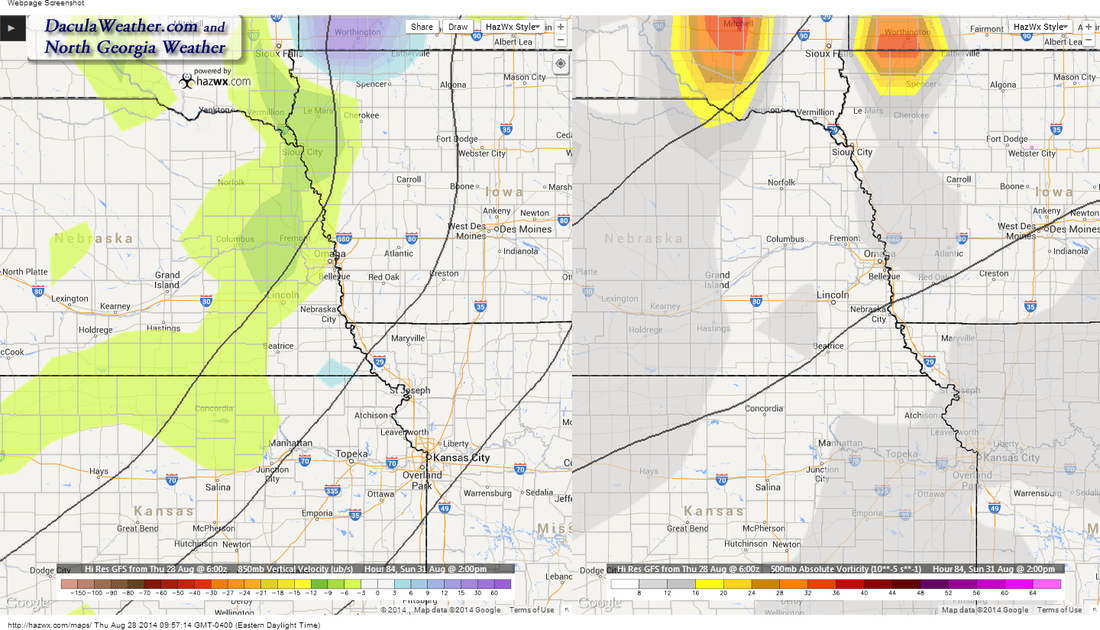 This is vertical velocity and vorticity, the lift and twist to the air as it rises. These are from two different levels. The left is an 850mb view (~5000 feet) and the right is a 500mb view (~18,000 feet). Note that they only line up to the north of the state, meaning the most likely area for severe is to the north. 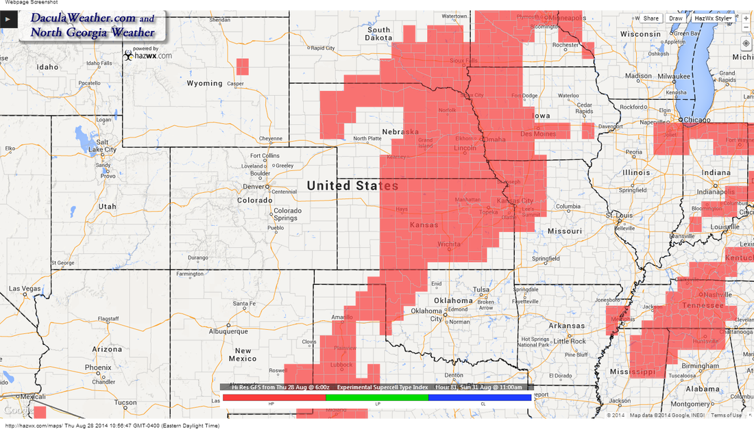 The parameters exist for some High Precipitation (HP) supercells, this is 11am Sunday. Again, something we'll be watching for as we get closer to Sunday. Updated 9:17 pm, Thursday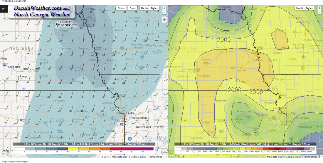 In case my regular readers are wondering what in the heck I'm talking about... The SCCA (Sports Car Club of America) Solo National Championship is held in Lincoln Nebraska starting this weekend and running through next weekend. It is billed as the largest motor sports event in the world with almost 1200 competitors this year. People come from around the country and Canada to try to win the coveted "Jacket" and a National Championship. I've talked about this sport in previous blog post, but here's a link just in case you missed it. Oh... and I'm participating. :-) Weather is always an important factor in any type of racing, and this one is no different. So with that, we going to take a preliminary look at what may happen. Things will change and I'll be making updates as necessary. We'll start by taking a look at the Area Forecast Discussion issued by the Omaha NWS office: .LONG TERM...(FRIDAY NIGHT THROUGH TUESDAY) ISSUED AT 318 AM CDT WED AUG 27 2014 A FEW SHOWERS LINGER INTO FRIDAY NIGHT...BUT SATURDAY LOOKS MAINLY DRY. THERE IS STILL SOME POCKETS OF MOISTURE AND ELEVATED INSTABILITY SO WILL NEED TO KEEP AN EYE ON THIS. LIFT INCREASES SATURDAY NIGHT THROUGH SUNDAY NIGHT AS ANOTHER SHORTWAVE TROF AFFECTS THE AREA WITH A GOOD CHANCE FOR RAIN SUNDAY NIGHT. What this means is that the weak ridge should bring decent weather for the Pro Solo Championship, but some showers may develop Sunday and into Monday as a trough enters the state and begins to flatten out or weaken. Shortwaves rounding the base of the trough will trigger some light showers through the period... but the timing is unknown right now. There doesn't appear to be any major rain events for the beginning of the event, all of that appears to stay to the north and east. But images speak louder than words (my words anyway...) to here is a visual look at what may happen. I'm going to save the Tue/Wed forecast for another day or so in order to get a clearer picture of the way things will evolve. 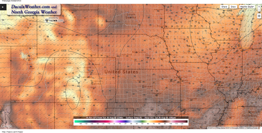
These are the temperatures for Saturday around 2pm. If you like low 80's you'll like Saturday. It may start off cloudy with a few showers around, but start to clear as the weak low in the upper right of the image, moves to the northeast. 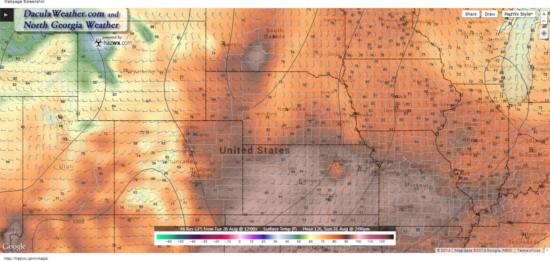
Sunday brings a mixed bag as the trough swings southeast from South Dakota. Notice the temperatures range from 90 to the mid 70's. 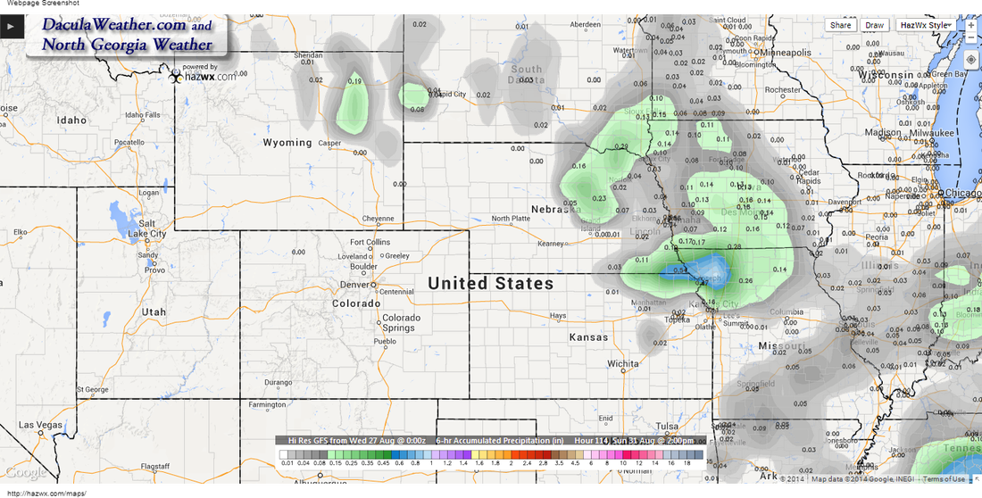
6 hour accumulated precipitation ending at 2pm Sunday. It may be damp in the morning hours as a shortwave passes through. 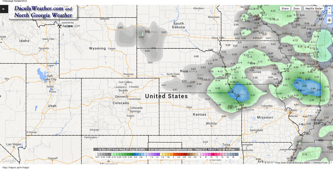
Again Monday at 8am. This would indicate showers occurred overnight. Monday appears to be a mostly cloudy day at this point. 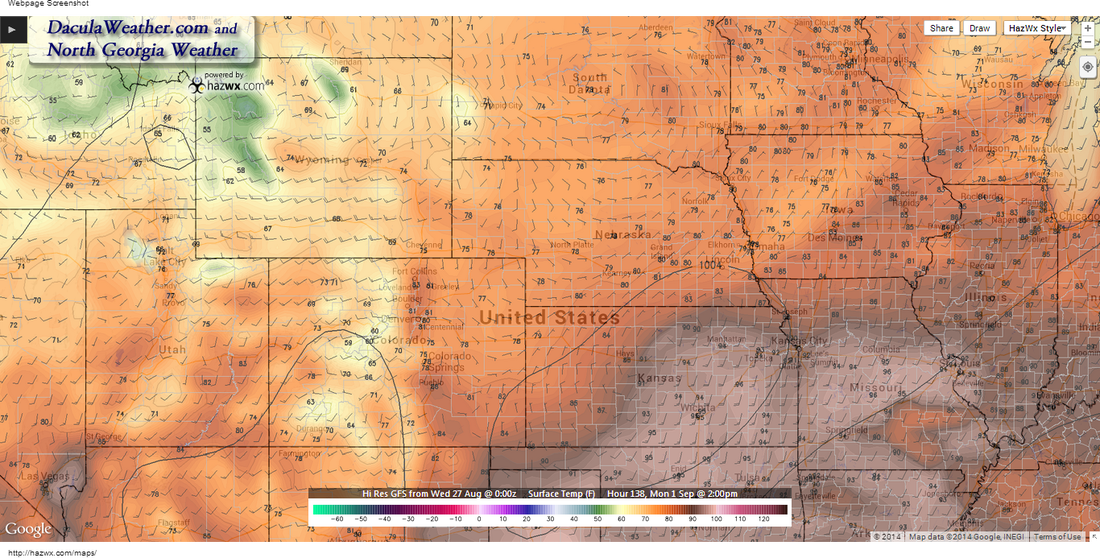
Temps on Monday. Luckily we're on the cooler side of things. 90's to the south. Note that Lincoln is just north of the front with winds out of the northeast. Also note the 1004mb contour, as that piece of energy may bring some showers to the area.
This week may be the hottest week of the year for us here in Georgia and much of the southeast. A large area of high pressure is forecast to form to our west and bring temperatures close to the century mark here in Georgia. The Weather Prediction had this to say Monday morning in their Extended Forecast Discussion: EXTENDED FORECAST DISCUSSION I added temperature maps for 5pm Tuesday through Sunday. These are from the GFS forecast model and paint a pretty hot picture. According to the GFS, it appears that Thursday may be the hottest day for us with temperatures well into the upper 90's, with some places in central and south Georgia over 100 degrees. Look for the heat index to possibly reach 105-100 F in central to south Georgia. 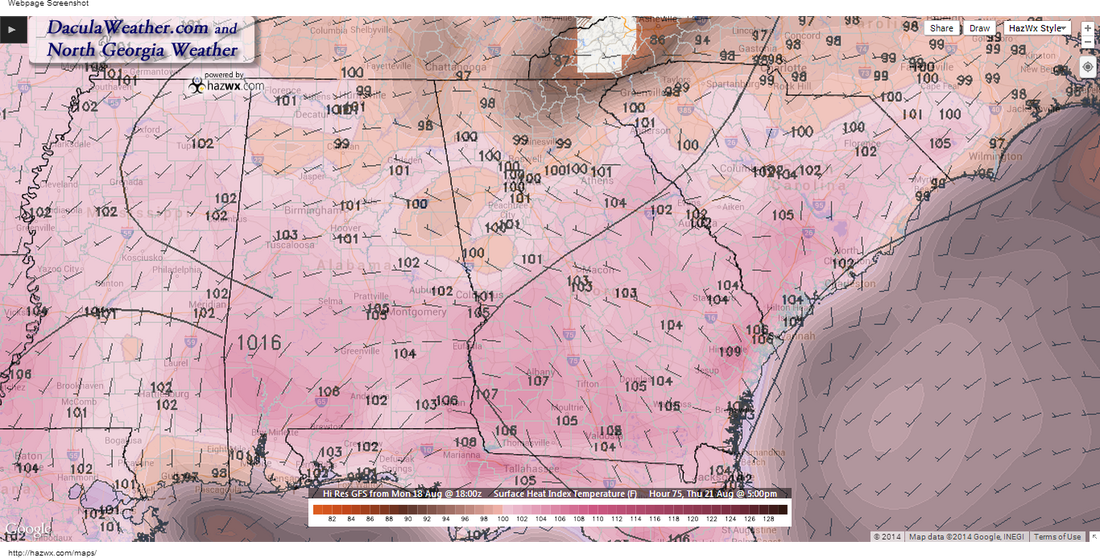 Heat Index Thursday 5PM 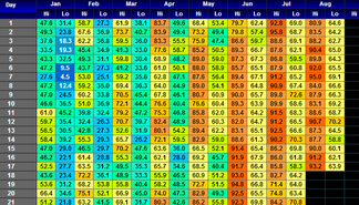 I keep detailed day by day temperature readings here at DaculaWeather.com, and the longest streak of 90+ days this year was a 9 day stretch from June 15 through June 23, when I recorded a high of 94.8 F and an average high of 92.3 F. You can find all of this temperature data by clicking here. I also have a page with yearly highs and lows here. Both pages update shortly after midnight. And as long as we're talking about temperatures, I have a page where you can find the highest highs and lowest lows for any area in the world. It's interesting to see what places are hot versus cold. If you look now, you'll find some pretty cold temperatures in Antarctica right now, and I like using this during the winter months. The link is here. So far our high for the year (recorded here) was 95.7 F on July 2nd. Will we go higher than that this week? Any guesses how high we'll go?
|
Archives
March 2019
Categories
All
|
OLD NORTH GA WX BLOG
 RSS Feed
|
Never base important decisions on this or any weather information obtained from the Internet. Always have a backup method of receiving weather information such as a battery powered weather radio.
Copyright © 2018 NorthGeorgiaWX.com and DaculaWeather.com 
|